New York WMU 4Z: deer and bear hunting, harvest and public land
New York's WMU 4Z covers 252 square miles in Columbia and Dutchess counties, in DEC's Southern Zone. DEC estimates hunters took 1,080 deer here in 2025 (572 adult bucks and 508 antlerless deer) and 21 bears. 7.8% of the WMU is public land, the largest share state park (8,529 acres), by the USGS Protected Areas Database.
Data updated October 2026. Deer: DEC 2025 Deer Harvest Summary. Bears: DEC 2025 Bear Harvest Summary. Seasons: DEC's September and October 2026 releases. Land: PAD-US 4.1 and DEC Lands.
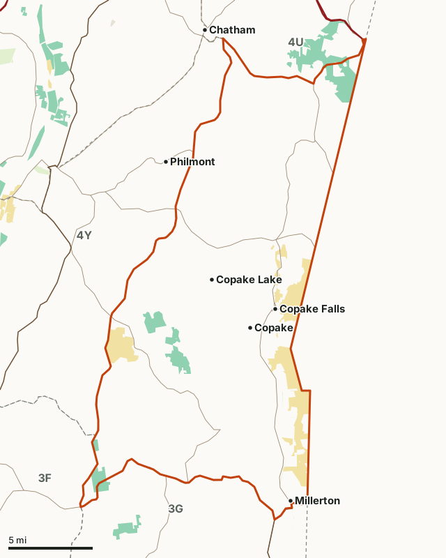
DEC landState parkNational Park ServiceOther state landWMU 4ZNeighboring WMUsHighway
| Zone | Southern Zone |
|---|---|
| Size | 252 square miles (DEC) |
| Counties | Columbia and Dutchess |
| Public land | 7.8% (12,595 acres) |
| DEC land | 3,894 acres: state forest 2,343, wildlife management area 1,078 and multiple use area 473 |
| Wildlife management areas | Doodletown WMA |
| Deer harvested, 2025 | 1,080 (572 adult bucks, 508 antlerless) |
| Bucks per square mile, 2025 | 2.3 (DEC) |
| Bears harvested, 2025 | 21 |
| Regular firearms deer, 2026 | November 21 to December 13 |
| Deer Management Permits, 2026 | By application (see DEC) |
How many deer are harvested in WMU 4Z?
DEC estimates 1,080 deer were taken in WMU 4Z in 2025, up from 1,006 in 2024. 572 were adult bucks, 2.3 for every square mile.
| Year | Adult bucks | Buck fawns | Adult does | Doe fawns | Total | Bucks per sq mi | Antlerless per sq mi |
|---|---|---|---|---|---|---|---|
| 2025 | 572 | 45 | 401 | 62 | 1,080 | 2.3 | 2 |
| 2024 | 510 | 47 | 402 | 47 | 1,006 | 2 | 2 |
| 2023 | 572 | 58 | 331 | 56 | 1,017 | 2.3 | 1.8 |
| 2022 | 657 | 54 | 428 | 48 | 1,187 | 2.6 | 2.1 |
Sources: DEC 2025 Deer Harvest Summary; DEC 2024 Deer Harvest Summary; DEC 2023 Deer Harvest Summary; DEC 2022 Deer Harvest Summary. DEC adds the harvest reports hunters file to its checks of deer at processors; these are its estimates.
How many bears are taken in WMU 4Z?
DEC estimates 21 bears were taken in WMU 4Z in 2025.
| Year | Bears |
|---|---|
| 2025 | 21 |
| 2024 | 29 |
Sources: DEC 2025 Bear Harvest Summary; DEC 2024 Bear Harvest Summary. DEC's 2023 summary is not online, and its earlier tables are laid out too differently to read reliably, so they are left out.
When are the 2026 seasons in WMU 4Z?
| Season | Dates, 2026 |
|---|---|
| Deer, early bowhunting (most of the zone) | October 1 to November 20 |
| Deer, regular firearms | November 21 to December 13 |
| Youth firearms big game hunt (ages 12 to 15) | October 10 to 12 |
| Bear, early bowhunting (most of the zone) | October 1 to November 20 |
Sources: DEC, 2026-27 early big game hunting seasons in September; DEC, 2026 big game hunting seasons in October. The Southern Zone regular season dates follow DEC's rule: it opens the third Saturday of November and runs 23 days. DEC's 2026-27 Hunting and Trapping Guide has every late bow and muzzleloader season; check DEC's seasons page before you go.
How much public land is in WMU 4Z?
7.8% of WMU 4Z is public land: 12,595 of its 161,583 acres. The largest share is state park, 8,529 acres.
| Manager | Acres | Share of WMU 4Z |
|---|---|---|
| State park | 8,529 | 5.3% |
| DEC land | 4,013 | 2.5% |
| Other state land | 53 | under 0.1% |
Measured by FilledTag inside DEC's WMU boundary from USGS Protected Areas Database of the United States (PAD-US 4.1). DEC land takes in the Forest Preserve, state forests and WMAs. Hunting is allowed on most of it; state parks, refuges and Park Service land allow it only in places.
DEC land in WMU 4Z, by kind
| Kind of DEC land | Acres in WMU 4Z |
|---|---|
| State forest | 2,343 |
| Wildlife management area | 1,078 |
| Multiple use area | 473 |
Measured by FilledTag from DEC Lands.
Wildlife management areas in WMU 4Z
| WMA | Acres in WMU 4Z |
|---|---|
| Doodletown WMA | 1,078 |
Which WMUs border WMU 4Z?
| WMU | Zone | Public land | Deer, 2025 | Adult bucks, 2025 | Bears, 2025 |
|---|---|---|---|---|---|
| WMU 3F | Southern | 3.1% | 735 | 462 | 5 |
| WMU 3G | Southern | 3.6% | 1,133 | 669 | 18 |
| WMU 4U | Southern | 4.3% | 424 | 284 | 11 |
| WMU 4Y | Southern | 1.6% | 734 | 396 | 4 |
Highways crossing WMU 4Z: NY 22 (30 miles), NY 82 (15 miles), NY 23 (10 miles), NY 71 (2 miles) and NY 344 (2 miles). Towns inside: Millerton.
Questions hunters ask
How many deer are harvested in WMU 4Z?
DEC estimates 1,080 deer were taken in WMU 4Z in 2025: 572 adult bucks, 401 adult does and 107 fawns. In 2024 the total was 1,006. The 4-year average from 2022 is 1,073 a year, worked out from DEC's figures.
When is deer season in WMU 4Z in 2026?
WMU 4Z is in the Southern Zone: early bowhunting October 1 to November 20 in most of the zone, then the regular firearms season from November 21 to December 13, 2026.
How many bears are taken in WMU 4Z?
DEC estimates 21 bears were taken in WMU 4Z in 2025, against 29 in 2024.
How much public land is in WMU 4Z?
12,595 acres, 7.8% of the WMU, by PAD-US 4.1. DEC's own land map shows 3,894 acres of DEC land here, the most of it state forest (2,343 acres). Wildlife management areas: Doodletown (1,078 acres here).
Are Deer Management Permits unlimited in WMU 4Z?
No. WMU 4Z is not among the 23 WMUs with unlimited DMPs in 2026; DMPs there are issued through DEC's application. A reported antlerless deer on any antlerless tag still earns a second antlered deer tag.
Get a New York hunt plan when they open
Hunt plans for New York are coming. Join the list and you'll hear first. The first 50 hunters in each new state get their plan free.
Until then, the free FilledTag app for iPhone has a map that works in every state, New York included.
Where these numbers come from
- Deer harvest: DEC 2025 Deer Harvest Summary; DEC 2024 Deer Harvest Summary; DEC 2023 Deer Harvest Summary; DEC 2022 Deer Harvest Summary. Bears: DEC 2025 Bear Harvest Summary; DEC 2024 Bear Harvest Summary.
- Seasons, DMPs and Earn-a-2nd-Buck: DEC, 2026-27 early big game hunting seasons in September; DEC, 2026 big game hunting seasons in October.
- WMU boundary: DEC Wildlife Management Units. DEC land: DEC Lands. WMAs: DEC Wildlife Management Areas. Public land: USGS Protected Areas Database of the United States (PAD-US 4.1).
- Highways and towns: U.S. Census Bureau TIGER/Line 2024 primary and secondary roads; U.S. Census Bureau 2024 Gazetteer, places.
FilledTag is not part of the New York State Department of Environmental Conservation. Numbers are copied from DEC and federal sources, or measured from their maps; nothing on this page is estimated by FilledTag.