Elk unit E1E, North Dakota: licenses, lottery and hunting land
North Dakota elk unit E1E covers 4,942 square miles, across Cavalier, Walsh, Pembina and Grand Forks counties and others. In the 2026 elk lottery NDGF offered 116 licenses for unit E1E (91 antlerless elk and 25 any elk), and 4,365 applications named it. In 2025, 134 elk hunters in unit E1E took 33 bulls and 36 cows and calves, a 51.49% success rate by NDGF's count. 1.7% of the unit is public land, mostly waterfowl production area, and 59,379 acres are PLOTS walk-in land on private ground (NDGF map layers, 2026).
Data updated October 2026. Lottery: NDGF, 2017 to 2026. Harvest: NDGF, 2025. Land: NDGF map layers, 2026. Seasons: NDGF 2026-27 table.
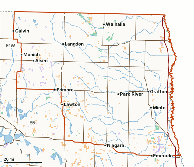
NDGF wildlife management areaWaterfowl production areaNational wildlife refuge (rules vary)BLMCorps of EngineersBureau of ReclamationState trust landState forestState park (rules vary)PLOTS (private land open to hunting)Unit E1ENeighboring unitsLake or riverHighway
| Size | 3,162,802 acres (4,942 square miles) |
|---|---|
| Counties | Cavalier, Walsh, Pembina, Grand Forks, Ramsey, Nelson |
| Licenses, 2026 lottery | 116: 91 antlerless elk and 25 any elk |
| Applications, 2026 | 4,365 |
| Elk harvest, 2025 | 69 by 134 hunters (51.49% success) |
| Public land | 1.7% (54,619 acres) |
| PLOTS walk-in land | 59,379 acres; 436 tracts centered in the unit |
| Wildlife management areas | 33 (22,803 acres) |
| Elk gun season, 2026 | October 2, 2026 to January 3, 2027 |
| Towns in and near it | Alsen, Loma, Grafton, Edmore and Calvin |
How many elk licenses does unit E1E get?
In the 2026 elk lottery NDGF offered 116 licenses for unit E1E (91 antlerless elk and 25 any elk), and 4,365 applications named it. NDGF made 60 licenses available here in 2017 and 116 in 2026.
| Year | License | Licenses available | Applications |
|---|---|---|---|
| 2026 | Antlerless Elk | 91 | 143 |
| 2026 | Any Elk | 25 | 4,222 |
| 2025 | Antlerless Elk | 91 | 153 |
| 2025 | Any Elk | 25 | 4,040 |
| 2024 | Antlerless Elk | 110 | 192 |
| 2024 | Any Elk | 22 | 3,949 |
| 2023 | Antlerless Elk | 97 | 181 |
| 2023 | Any Elk | 20 | 3,965 |
| 2022 | Antlerless Elk | 80 | 181 |
| 2022 | Any Elk | 30 | 3,684 |
| 2021 | Antlerless Elk | 60 | 180 |
| 2021 | Any Elk | 30 | 3,436 |
| 2020 | Antlerless Elk | 60 | 200 |
| 2020 | Any Elk | 30 | 3,187 |
| 2019 | Antlerless Elk | 60 | 193 |
| 2019 | Any Elk | 30 | 2,939 |
| 2018 | Antlerless Elk | 50 | 184 |
| 2018 | Any Elk | 10 | 2,768 |
| 2017 | Any Elk | 10 | 2,623 |
| 2017 | Cow Elk | 50 | 196 |
Source: NDGF elk lottery statistics and NDGF elk lottery archive; NDGF notes small differences from voided, revoked or refunded licenses. NDGF prints licenses available and total applications for elk; it does not print bonus points by level for elk.
How many elk were taken in unit E1E in 2025?
NDGF reports 134 hunters in unit E1E in 2025 took 33 bulls and 36 cows and calves, a 51.49% success rate. Statewide, 929 elk hunters took 576 elk.
Source: NDGF, 2025 Big 3 Harvest Statistics.
How much public land and PLOTS is in unit E1E?
1.7% of unit E1E is public land: 54,619 of its 3,162,802 acres. The largest share is waterfowl production area, 27,244 acres. PLOTS adds 59,379 acres of private land open to walk-in hunting; 436 PLOTS tracts are centered inside the unit.
| Manager | Acres | Share of unit E1E |
|---|---|---|
| PLOTS (private land open to hunting) | 59,379 | 1.9% |
| Waterfowl production area | 27,244 | 0.9% |
| NDGF wildlife management area | 22,811 | 0.7% |
| State park (rules vary) | 2,769 | 0.1% |
| State trust land | 1,961 | 0.1% |
| National wildlife refuge (rules vary) | 1,361 | under 0.1% |
| State forest | 571 | under 0.1% |
| Corps of Engineers | 406 | under 0.1% |
| BLM | 199 | under 0.1% |
| Bureau of Reclamation | 66 | under 0.1% |
Wildlife management areas in unit E1E: Pembina Hills WMA (5,043 acres here), Prairie Chicken WMA (4,273 acres here), Jay V. Wessels WMA (3,661 acres here), Charles V. Pulver WMA (1,679 acres here), Cavalier County WMA (1,435 acres here), Joliet Ferry WMA (978 acres here), Wilbur Allen WMA (670 acres here), Fitzsimond Slough WMA (619 acres here), Wall WMA (479 acres here), Barron WMA (427 acres here), Shirek WMA (390 acres here) and Charles C. Cook WMA (328 acres here), and 21 smaller ones.
Measured by FilledTag inside NDGF's unit boundary from NDGF PLOTS Guide map layers (WMAs, PLOTS, trust land, federal land). Where two maps overlap, the acres are counted once. State trust land is open to walk-in hunting unless the Department of Trust Lands lists the tract as closed; some tracts ask that the lessee be told first. National wildlife refuges are open to hunting only where each refuge's rules allow.
Which counties does unit E1E cover?
Unit E1E takes in parts of 6 counties. Each county's page lists its PLOTS land and WMAs.
| County | Acres in unit E1E | Share of the unit |
|---|---|---|
| Cavalier County | 872,946 | 27.6% |
| Walsh County | 827,949 | 26.2% |
| Pembina County | 717,437 | 22.7% |
| Grand Forks County | 408,123 | 12.9% |
| Ramsey County | 180,228 | 5.7% |
| Nelson County | 155,589 | 4.9% |
When is elk season in unit E1E in 2026?
Unit E1E has 4 elk season rows in NDGF's 2026-27 table. NDGF's note for the antlerless season of August 7 to September 27, 2026: This season is restricted to private land only within the boundaries of the hunter’s assigned unit. Hunting on private land enrolled in the Private Land Open To Sportsman program is prohibited, except by the enrolled landowner.
| Season | Where | Opens | Closes | Apply by |
|---|---|---|---|---|
| Elk: Antlerless | E1E, E1W, E2, E6, E7 | August 7, 2026 | September 27, 2026 | March 25, 2026 |
| Elk: Bow | E1E, E1W, E2, E6, E7 | September 4, 2026 | September 27, 2026 | March 25, 2026 |
| Elk: Regular | E1E, E2, E1W | October 2, 2026 | January 3, 2027 | March 25, 2026 |
| Elk: Antlerless | E1E, E1W, E2, E3, E4, E6, E7 | January 9, 2027 | January 17, 2027 | March 25, 2026 |
Source: NDGF 2026-27 season dates.
How do you get to unit E1E?
Highways through the unit: I-29 (about 151 miles inside it), US 81 (about 113 miles inside it), ND 66 (about 81 miles inside it), ND 17 (about 80 miles inside it) and ND 5 (about 79 miles inside it). Towns inside: Alsen, Loma, Grafton, Park River, Langdon, Minto and 38 more. Just outside: Edmore (on the line), Calvin (on the line), Niagara (on the line) and Emerado (on the line).
Which units border elk unit E1E?
Unit E1E touches 2 other elk units. Their 2026 licenses and land, for comparison:
| Unit | Licenses, 2026 | Applications | Public land | PLOTS acres |
|---|---|---|---|---|
| Unit E1W | 155 | 2,760 | 3.5% | 17,293 |
| Unit E5 | no lottery | 4.5% | 712,141 |
Questions hunters ask
How many people apply for an any-elk license in unit E1E?
NDGF counted 4,222 applications for unit E1E's 25 any-elk licenses in 2026. North Dakota elk licenses are for residents only and are drawn by lottery.
How much public land is in elk unit E1E?
1.7% of unit E1E, 54,619 of its 3,162,802 acres, is public land by the state and federal maps NDGF publishes; the largest share is waterfowl production area at 27,244 acres. Another 59,379 acres are PLOTS, private land the owner has opened to walk-in hunting.
What towns are in elk unit E1E?
Alsen, Loma, Grafton, Park River and Langdon are inside the unit, with 39 smaller places.
When is elk season in unit E1E in 2026?
Antlerless August 7 to September 27, 2026, bow September 4 to 27, 2026, regular October 2, 2026 to January 3, 2027 and antlerless January 9 to 17, 2027 for unit E1E. Dates are from NDGF's 2026-27 season table; the lottery deadline was March 25, 2026.
Get a North Dakota hunt plan when they open
Hunt plans for North Dakota are coming. Join the list and you'll hear first. The first 50 hunters in each new state get their plan free.
Until then, the free FilledTag app for iPhone has a map that works in every state, North Dakota included.
Where these numbers come from
- Licenses, applicants and bonus points: NDGF elk lottery statistics; NDGF elk lottery archive.
- Elk harvest: NDGF, 2025 Big 3 Harvest Statistics.
- Seasons: NDGF 2026-27 season dates.
- Unit boundary: NDGF hunting unit maps. Land: NDGF PLOTS Guide map layers (WMAs, PLOTS, trust land, federal land). Highways and towns: U.S. Census Bureau TIGER/Line 2024 and 2024 Gazetteer.
FilledTag is not part of the North Dakota Game and Fish Department. Numbers are copied from NDGF or measured from the maps it publishes; nothing on this page is estimated by FilledTag.
North Dakota hunting Unit E1W Cavalier County Walsh County Pembina County