Poston Plant Lands Hunting Area: hunting and access
Poston Plant Lands Hunting Area is 1,159 acres on ODNR's hunting map in Athens County, 2 miles from The Plains, listed by ODNR as open to hunting. Hunters checked 917 deer in Athens County in 2025-26.
Data updated October 2026. Area facts: ODNR's ODNR area open to hunting data, read 2026-10. Harvest: Division of Wildlife harvest reports, 2021-22 to 2025-26.
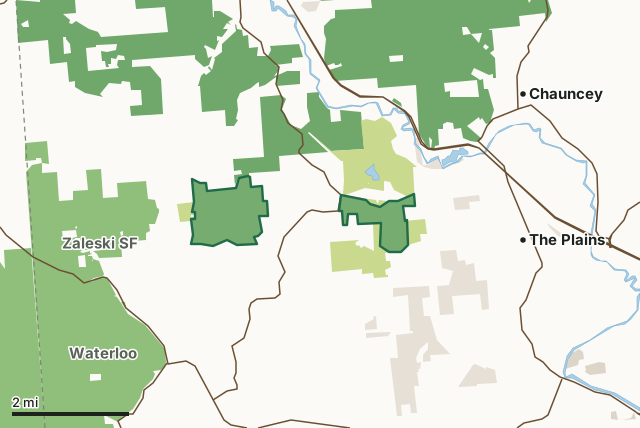
Land on ODNR's hunting mapNational forestOther state landMetro parks, county and city landLand trusts and other open landPoston Plant Lands Hunting AreaCounty lineLakeHighway
| Size | 1,159 acres in 2 pieces |
|---|---|
| County | Athens County |
| Deer harvest unit | Athens County |
| Hunting (ODNR) | Open |
| Kind (ODNR) | hunting area |
| Managed by | the Division of Wildlife |
| Held by ODNR as | agreement |
| Nearest towns | The Plains (2 mi), Chauncey (3 mi) and New Marshfield (3 mi) |
What are the rules on Poston Plant Lands Hunting Area?
ODNR's land layer lists the area as open to hunting under Ohio's statewide seasons and rules.
ODNR's hunting map for the area shows the boundaries, parking and any no-hunting zones.
Deer bag limits in Ohio are set by county; the Division's 2026-27 season list points to the bag limit map.
How many deer are taken around Poston Plant Lands Hunting Area?
Poston Plant Lands Hunting Area lies in Athens County. Hunters checked 917 deer in Athens County in 2025-26, against 3,663 in 2024-25.
| County | Poston Plant Lands Hunting Area acres in it | Deer, 2025 | Deer, 2024 | Deer, 2023 |
|---|---|---|---|---|
| Athens County | 1,159 | 917 | 3,663 | 2,924 |
Harvest for the whole county, not the hunting area alone: the Division of Wildlife's 2025-26, 2024-25 and 2023-24 final deer harvest reports and Publication 5304 (2021-22).
How do you get to Poston Plant Lands Hunting Area?
Nearest towns: The Plains (2 miles), Chauncey (3 miles), New Marshfield (3 miles) and Athens (5 miles). Highways within 5 miles: US 33, OH 56, OH 278, OH 691 and OH 682.
What other public land is near Poston Plant Lands Hunting Area?
ODNR areas open to hunting within 10 miles:
- Zaleski State Forest: 28,637 acres, 0.5 miles away
- Waterloo Wildlife Area: 2,660 acres, 1.5 miles away
- Fox Lake Wildlife Area: 450 acres, 4.2 miles away
- Strouds Run State Park: 2,567 acres, 5.5 miles away
- Wallace H. O'Dowd Wildlife Area: 10,149 acres, 6.9 miles away
- Taylor Ridge Wildlife Area: 1,226 acres, 7.7 miles away
Public land within 3 miles of Poston Plant Lands Hunting Area
Counting Poston Plant Lands Hunting Area itself, 13,213 of the 38,755 acres within 3 miles of its boundary are public land open to the public (34.1%), by USGS PAD-US 4.1 and ODNR's land boundaries.
| Manager | Acres within 3 miles |
|---|---|
| National forest | 5,601 |
| Land on ODNR's hunting map | 5,259 |
| Land trusts and other open land | 1,177 |
| Other state land | 1,176 |
Questions hunters ask
Where is Poston Plant Lands Hunting Area?
In Athens County, 2 miles from The Plains.
Can you hunt on Poston Plant Lands Hunting Area?
Yes. ODNR's layer lists it as open to hunting under Ohio's statewide seasons.
How much public land is around Poston Plant Lands Hunting Area?
13,213 acres within 3 miles of its boundary, Poston Plant Lands Hunting Area included, by USGS PAD-US 4.1 and ODNR's land boundaries. The closest other ODNR area open to hunting is Zaleski State Forest (0.5 miles).
Get a Ohio hunt plan when they open
Hunt plans for Ohio are coming. Join the list and you'll hear first. The first 50 hunters in each new state get their plan free.
Until then, the free FilledTag app for iPhone has a map that works in every state, Ohio included.
Where these facts come from
- Area description, species, rules and directions: ODNR, Poston Plant Lands Hunting Area; ODNR lands hunting status.
- Boundary and acres: ODNR's map layer above. Surrounding public land: USGS PAD-US 4.1 (fee land open to the public) and ODNR's land boundaries with hunting status.
- Deer harvest: the Division of Wildlife's 2025-26, 2024-25 and 2023-24 final deer harvest reports and Publication 5304 (2021-22).
FilledTag is not part of the Ohio Department of Natural Resources, Division of Wildlife. Check ODNR's rules and posted signs before you go.