McCurtain County, Oklahoma: deer harvest, public land and seasons
Hunters took 3,172 deer in McCurtain County in 2025-26, 3rd of Oklahoma's 77 counties, by ODWC's Big Game Harvest Report (1,539 antlered, 1,633 antlerless). That count leaves out deer taken on wildlife management areas and OLAP land. McCurtain County's harvest went from 3,445 in 2020-21 to 3,172 in 2025-26 (down 8%). The county holds 332,293 acres of WMA land in 10 areas.
Data updated October 2026. Harvest: ODWC's Big Game Harvest Reports, 2020-21 to 2025-26. Public land: ODWC's WMA and OLAP maps, 2026.
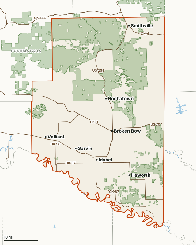
Wildlife management areaOLAP walk-in tractCounty lineLake or riverHighway
| Deer harvested, 2025-26 | 3,172 (3rd of 77 counties) |
|---|---|
| Antlered and antlerless, 2025-26 | 1,539 and 1,633 |
| Highest of six seasons | 3,445 in 2020-21 |
| Size | 1,851 square miles of land |
| Wildlife management areas | Three Rivers WMA, Ouachita WMA McCurtain Unit, Herron Family WMA, McCurtain County Wilderness Area, Pine Creek WMA, Red Slough WMA, Honobia Creek WMA, Broken Bow WMA, Grassy Slough WMA, Whitegrass Flats WMA |
| OLAP walk-in hunting | None in ODWC's 2026 layer |
| CWD | Inside a Selective Surveillance Area (SSA) |
| Bear season | Open in the county |
| Towns | Idabel, Hochatown, Broken Bow, Valliant and Garvin |
How many deer are harvested in McCurtain County?
ODWC's yearly count for McCurtain County, every deer checked in the county outside wildlife management areas and OLAP land. McCurtain County's harvest went from 3,445 in 2020-21 to 3,172 in 2025-26 (down 8%).
| Season | Deer harvested | Antlered | Antlerless | Archery | Gun | Muzzleloader |
|---|---|---|---|---|---|---|
| 2025-26 | 3,172 | 1,539 | 1,633 | 849 | 1,772 | 551 |
| 2024-25 | 3,010 | 1,390 | 1,620 | 962 | 1,653 | 395 |
| 2023-24 | 2,765 | 1,390 | 1,375 | 798 | 1,472 | 495 |
| 2022-23 | 3,353 | 1,565 | 1,788 | 946 | 1,966 | 441 |
| 2021-22 | 2,842 | 1,544 | 1,298 | 876 | 1,531 | 435 |
| 2020-21 | 3,445 | 1,893 | 1,552 | 965 | 1,772 | 708 |
Source: ODWC Big Game Harvest Reports (2025-26, 2024-25, 2023-24, 2022-23, 2021-22, 2020-21), Table 1, harvest by county, sex and method. The 2020-21 report labels the columns female and male. Each table was checked against its printed totals.
McCurtain County deer by method and sex, 2025-26
| Method | Antlerless | Antlered | Total |
|---|---|---|---|
| Archery | 478 | 371 | 849 |
| Gun | 955 | 817 | 1,772 |
| Muzzleloader | 200 | 351 | 551 |
Mule deer, elk, pronghorn and bear in McCurtain County
ODWC's county tables for its other big game, in the seasons whose tables reconcile:
| Species | 2025-26 | 2024-25 | 2023-24 | 2022-23 | 2021-22 | 2020-21 |
|---|---|---|---|---|---|---|
| Black bear | 6 | 6 |
Blank means the county had no row that season or that season's table did not reconcile (mule deer in 2025-26 and 2023-24, elk in 2023-24 and 2020-21).
Where can you hunt public land in McCurtain County?
McCurtain County holds 332,293 acres of ODWC wildlife management area land, 27.3% of the county:
| Area | Acres in the county | Deer harvested on the whole area, 2025-26 |
|---|---|---|
| Three Rivers WMA | 150,544 | 305 |
| Ouachita WMA McCurtain Unit | 126,260 | 150 |
| Herron Family WMA | 17,228 | |
| McCurtain County Wilderness Area | 15,606 | 38 |
| Pine Creek WMA | 6,643 | 33 |
| Red Slough WMA | 5,956 | 66 |
| Honobia Creek WMA | 4,765 | 124 |
| Broken Bow WMA | 3,218 | 41 |
| Grassy Slough WMA | 1,662 | 2 |
| Whitegrass Flats WMA | 411 |
What is McCurtain County like?
McCurtain County covers 1,851 square miles of land. Its towns include Idabel, Hochatown, Broken Bow, Valliant, Garvin and Millerton. Highways: OK 3 (72 miles in the county), US 70 (62 miles in the county), US 259 (57 miles in the county), OK 87 (33 miles in the county) and OK 98 (20 miles in the county). Water: Gunn Lake, Ward Lake, Forty-one Cut-off Lake, Mountain Fork and Crooked Creek. McCurtain County is inside one of ODWC's CWD Selective Surveillance Areas: deer and elk taken there must be processed before they leave it. Bear archery and muzzleloader seasons are open in the county.
How does McCurtain County compare with its neighbors?
| County | Deer harvested, 2025-26 | Rank of 77 |
|---|---|---|
| McCurtain | 3,172 | 3 |
| Choctaw | 1,837 | 25 |
| Le Flore | 2,298 | 11 |
| Pushmataha | 2,049 | 24 |
When are Oklahoma's 2026 deer seasons?
Deer seasons are statewide; antlerless days and limits are set by zone, and ODWC draws its antlerless zones along highways, so check ODWC's antlerless zone map for McCurtain County. The combined season limit is six deer, no more than two antlered.
| Season | 2026-27 dates |
|---|---|
| Deer archery | Oct. 1, 2026 to Jan. 15, 2027 |
| Youth deer gun | Oct. 16-18, 2026 |
| Deer muzzleloader | Oct. 24 to Nov. 1, 2026 |
| Deer gun | Nov. 21 to Dec. 6, 2026 |
| Holiday antlerless deer gun | Dec. 18-31, 2026 |
Source: ODWC 2026-27 deer seasons. Wildlife management areas can close or shorten a season; each WMA's page lists its own.
Questions hunters ask
How many deer are harvested in McCurtain County, Oklahoma?
ODWC counts 3,172 deer taken in McCurtain County in 2025-26, leaving out WMA and OLAP land. Over the six seasons from 2020-21 the county ranged from 2,765 (2023-24) to 3,445 (2020-21).
Is there public hunting land in McCurtain County?
Yes: Three Rivers WMA (150,544 acres in the county), Ouachita WMA - McCurtain (126,260 acres in the county), Herron Family WMA (17,228 acres in the county), McCurtain County Wilderness Area (15,606 acres in the county), Pine Creek WMA (6,643 acres in the county), Red Slough WMA (5,956 acres in the county), Honobia Creek WMA - Campbell (4,765 acres in the county), Broken Bow WMA (3,218 acres in the county), Grassy Slough WMA (1,662 acres in the county) and Whitegrass Flats WMA (411 acres in the county).
When is deer gun season in McCurtain County in 2026?
Statewide: Nov. 21 to Dec. 6, 2026, with muzzleloader Oct. 24 to Nov. 1 and archery Oct. 1, 2026 to Jan. 15, 2027. How many antlerless deer you may take depends on the antlerless zone, which ODWC maps by highways rather than county lines. WMAs set their own rules.
Which method takes the most deer in McCurtain County?
In 2025-26: gun 1,772, archery 849, muzzleloader 551, by ODWC's table.
Get a Oklahoma hunt plan when they open
Hunt plans for Oklahoma are coming. Join the list and you'll hear first. The first 50 hunters in each new state get their plan free.
Until then, the free FilledTag app for iPhone has a map that works in every state, Oklahoma included.
Where these numbers come from
- Harvest by county: ODWC Big Game Harvest Reports, 2025-26, 2024-25, 2023-24, 2022-23, 2021-22, 2020-21. The 2023-24 and 2020-21 tables are pictures, read by OCR and kept only where they match ODWC's printed totals.
- Wildlife management areas: ODWC Public WMA Boundaries. OLAP: ODWC OLAP layer. Acres measured by FilledTag.
- Seasons: ODWC 2026-27 hunting regulations. County, towns and highways: U.S. Census Bureau TIGER/Line 2024.
FilledTag is not part of the Oklahoma Department of Wildlife Conservation. Nothing on this page is estimated by FilledTag.
Oklahoma hunting Choctaw County Le Flore County Pushmataha County