Keystone WMA: deer harvest, rules and map
Keystone WMA is 22,405 acres of public hunting land in Creek County, Pawnee County and Osage County, managed by ODWC. Hunters took 272 deer on it in 2025-26, by ODWC's Big Game Harvest Report, and 235 a season on average over the 6 seasons ODWC published. Deer gun, by ODWC's 2026-27 rules for the area: Open during the first nine days only and Cottonwood Creek Wetland Development Unit lands are closed.
Data updated October 2026. Harvest: ODWC's Big Game Harvest Reports. Rules: ODWC's 2026-27 special area regulations. Boundary: ODWC's WMA map.
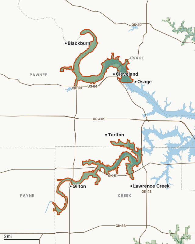
This areaOther wildlife management areaOLAP walk-in tractCounty lineLake or riverHighway
| Size | 22,405 acres (ODWC) |
|---|---|
| County | Creek, Pawnee, Osage, Payne |
| ODWC region | Central |
| Deer harvested, 2025-26 | 272 |
| Deer per 1,000 acres, 2025-26 | 12.1 (worked out from ODWC's two figures) |
| Deer gun season | Open during the first nine days only and Cottonwood Creek Wetland Development Unit lands are closed. |
| Camping | Hunter and angler camping is allowed within 50 yards of open roads. |
| Area contact | (918) 629-4625 |
| Towns | Oilton (next to it), Osage (next to it) and Cleveland (next to it) |
How many deer are harvested on Keystone WMA?
ODWC's count of deer taken on Keystone WMA, season by season, from its WMA harvest table.
| Season | Deer harvested | Antlered | Antlerless | Archery | Gun | Muzzleloader |
|---|---|---|---|---|---|---|
| 2025-26 | 272 | |||||
| 2024-25 | 235 | 82 | 153 | 105 | 97 | 33 |
| 2023-24 | 278 | 100 | 178 | 87 | 149 | 42 |
| 2022-23 | 270 | 108 | 162 | 120 | 122 | 28 |
| 2021-22 | 226 | 91 | 135 | 92 | 113 | 21 |
| 2020-21 | 131 |
Source: ODWC Big Game Harvest Reports (2025-26, 2024-25, 2023-24, 2022-23, 2021-22, 2020-21), Table 2, WMA harvest by sex and method. A season missing from the table had no row for the area or its table did not reconcile. Method and sex columns are left blank for 2025-26 and 2020-21: that year's table adds up row by row and to its printed total, but its columns do not match the printed column totals, so only the totals are used.
What are the 2026-27 hunting rules on Keystone WMA?
- That portion of the Arkansas Arm of the Keystone WMA that was previously the Waterfowl Refuge is open to restricted hunting. Lands in Osage County and the Arkansas River are restricted to archery and shotgun with pellets only. Lands in Pawnee County are restricted to archery only. The western boundary of these restricted hunting areas is a northern extension of Swan Drive in the city of Cleveland; the southern boundary is the old railroad trestle.
- All shotgun hunting is restricted to federally approved nontoxic shot on the Boston Pool, Buckeye Creek and Cottonwood Creek WDU portions.
Same as statewide: Deer Archery, Deer Muzzleloader, Youth Deer Gun, Dove, Rail, Gallinule and Turkey Fall Archery.
Seasons with special restrictions
- Deer Gun: Open during the first nine days only and Cottonwood Creek Wetland Development Unit lands are closed.
- Holiday Antlerless Deer Gun: Same as statewide seasons except Cottonwood Creek Wetland Development Unit lands are closed.
- Crow, Quail, Woodcock, Snipe, Rabbit, Squirrel, Predator/ Furbearer Calling, Pursuit with Hounds: Closed during the first nine days of deer gun season.
- Turkey Fall Gun: Tom only, shotgun only.
- Waterfowl: Hunting hours for waterfowl close at 1 p.m. daily on the WDU portions.
- Trapping: Open to water sets, live box traps and enclosed trigger traps only.
- Turkey Spring, Youth Turkey Spring: One-tom limit; seasons combined, area combined.
Other restrictions
- Hunter and angler camping is allowed within 50 yards of open roads.
Source: ODWC 2026-27 special area regulations, Keystone WMA.
How do you get to Keystone WMA?
Keystone WMA lies in Creek County, Pawnee County, Osage County and Payne County. Nearest towns: Oilton (next to it), Osage (next to it), Cleveland (next to it) and Lawrence Creek (next to it). Highways within 5 miles: OK 99 (it crosses or touches the area), OK 51 (it crosses or touches the area), OK 48 (it crosses or touches the area), US 64 (it crosses or touches the area) and OK 33 (2.5 miles). Water: Cleveland Reservoir.
Which wildlife management areas are near Keystone WMA?
| Area | Distance | Deer harvested, 2025-26 |
|---|---|---|
| Skiatook WMA | 7.4 mi | 84 |
| Heyburn WMA | 8.3 mi | 53 |
| Deep Fork WMA | 24 mi | 106 |
| Candy Creek WMA | 24.7 mi | 28 |
| Kaw WMA | 29.8 mi | 389 |
OLAP walk-in hunting tracts within 20 miles: Osage_H002 (162 acres, 17.9 mi).
Questions hunters ask
How many deer are killed on Keystone WMA?
ODWC counts 272 deer on Keystone WMA in 2025-26. Its seasons on record: 2025-26 272, 2024-25 235, 2023-24 278, 2022-23 270, 2021-22 226 and 2020-21 131.
Is deer gun season open on Keystone WMA?
Yes, with limits. ODWC's 2026-27 rule: Deer Gun: Open during the first nine days only and Cottonwood Creek Wetland Development Unit lands are closed.
Can you camp on Keystone WMA?
Hunter and angler camping is allowed within 50 yards of open roads, by ODWC's 2026-27 regulations.
Where is Keystone WMA?
In Creek County, Pawnee County, Osage County and Payne County. Nearest towns: Oilton (next to it), Osage (next to it) and Cleveland (next to it).
Get a Oklahoma hunt plan when they open
Hunt plans for Oklahoma are coming. Join the list and you'll hear first. The first 50 hunters in each new state get their plan free.
Until then, the free FilledTag app for iPhone has a map that works in every state, Oklahoma included.
Where these facts come from
- Deer harvest: ODWC Big Game Harvest Reports, 2025-26, 2024-25, 2023-24, 2022-23, 2021-22, 2020-21, WMA table.
- Seasons and rules: ODWC 2026-27 hunting regulations, special area regulations.
- Boundary and acres: ODWC Public WMA Boundaries. Highways and towns: U.S. Census Bureau TIGER/Line 2024. Water: USGS NHD.
FilledTag is not part of the Oklahoma Department of Wildlife Conservation. ODWC's regulations and posted signs are the final word.
Oklahoma hunting Creek County Pawnee County Osage County Payne County Skiatook WMA Heyburn WMA Deep Fork WMA