Hunt 440A1 Columbia Plateau No. 1: Oregon pronghorn tags, draw and harvest
Oregon controlled hunt 440A1, Columbia Plateau No. 1, is one doe or fawn pronghorn, Oct. 17 to Oct. 25, with 55 tags for 2026 (ODFW regulations, page 60). In ODFW's June 2026 draw, 54 of 105 residents who put it first drew a tag. ODFW estimates 34 hunters took 13 pronghorn on this hunt in 2025, 38 for every 100 hunters.
Data updated October 2026. Tags and dates: ODFW's 2026 regulations. Draw: ODFW's 2026 Preference Point Draw Report. Harvest: ODFW, 2020 to 2025.
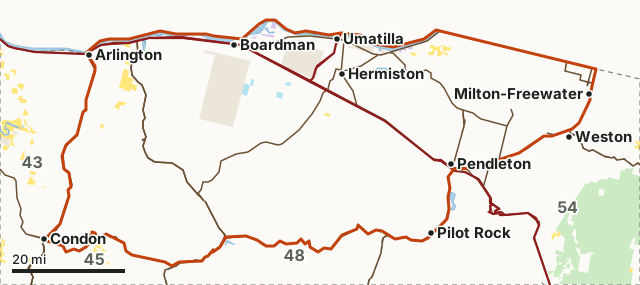
National wildlife refugeNational forestBLMODFW landState forest and trust landOther public (city, county, parks, military)Unit 44Lake, reservoir or riverHighway
The hunt's own boundary is ODFW's written description (the hunt covers part of the unit), regulations pages 94 to 101.| Bag limit | One doe or fawn pronghorn |
|---|---|
| 2026 season | Oct. 17 - Oct. 25 |
| Weapon | Any legal weapon |
| 2026 tags | 55 |
| First-choice applicants, 2026 draw | 105 residents, 4 nonresidents |
| Drawn, 2026 | 55 (1 nonresident) |
| Harvested, 2025 | 13 by 34 hunters |
| Units | 44 Columbia Basin, 43 Biggs, 48 Heppner, 40 Maupin |
How hard is it to draw hunt 440A1?
ODFW's 2026 report shows 105 residents and 4 nonresidents putting hunt 440A1 first for 55 tags; 54 residents drew, and 1 of 4 nonresidents, the most ODFW issues to nonresidents in a pronghorn hunt (3% of tags). In the preference phase, which fills 75% of the tags, the residents who drew had 2 points or more. In 2025: 167 resident first-choice applicants, 54 drew, for 55 tags.
| Points | First-choice applicants | Drew in the preference phase |
|---|---|---|
| 10 | 2 | 2 |
| 8 | 1 | 1 |
| 6 | 1 | 1 |
| 5 | 5 | 5 |
| 4 | 4 | 4 |
| 3 | 15 | 15 |
| 2 | 25 | 12 |
| 1 | 31 | 0 |
| 0 | 21 | 0 |
| Points | First-choice applicants | Drew in the preference phase |
|---|---|---|
| 2 | 1 | 1 |
| 1 | 2 | 0 |
| 0 | 1 | 0 |
Source: ODFW 2026 Pronghorn Antelope Preference Point Draw Report; ODFW 2025 Pronghorn Antelope Preference Point Draw Report. The table is ODFW's preference point phase only; tags drawn at random (25%) are not printed by point level.
How many pronghorn are taken on hunt 440A1?
ODFW's estimates for hunt 440A1, year by year: 13 from 34 hunters in 2025, 18 from 41 hunters in 2024, 13 from 35 hunters in 2023 and 17 from 35 hunters in 2022.
| Year | Hunters | Days hunted | Pronghorn harvested | Bucks | Does | Per 100 hunters |
|---|---|---|---|---|---|---|
| 2025 | 34 | 66 | 13 | 0 | 13 | 38 |
| 2024 | 41 | 117 | 18 | 1 | 17 | 44 |
| 2023 | 35 | 87 | 13 | 0 | 13 | 37 |
| 2022 | 35 | 96 | 17 | 0 | 17 | 49 |
| 2021 | 31 | 96 | 14 | 1 | 13 | 45 |
| 2020 | 36 | 101 | 16 | 2 | 14 | 44 |
Source: ODFW harvest statistics (2020 to 2025). Where a hunt covers several units ODFW prints a row for each; these are added up.
Which units does hunt 440A1 cover?
ODFW's 2025 rows put hunt 440A1 hunters in 4 units:
| Unit | Hunters, 2025 | Pronghorn harvested, 2025 | Public land in the unit |
|---|---|---|---|
| Unit 44 Columbia Basin | 21 | 10 | 1.3% |
| Unit 43 Biggs | 10 | 3 | 12.3% |
| Unit 48 Heppner | 3 | 0 | 34.1% |
| Unit 40 Maupin | 0 | 0 | 9.3% |
Public land measured by FilledTag from USGS PAD-US 4.1 (fee land by manager, 2025) for the whole unit, not the hunt's own boundary.
Questions hunters ask
How many tags does hunt 440A1 have?
ODFW lists 55 tags for hunt 440A1 (Columbia Plateau No. 1) in 2026, one doe or fawn pronghorn, Oct. 17 - Oct. 25 (regulations page 60). ODFW's 2025 draw report lists 55 tags for 2025.
How many points do you need to draw hunt 440A1?
In ODFW's 2026 draw, the fewest points a resident drew hunt 440A1 with in the preference phase was 2 (12 of 25 at that level drew). The other 25% of tags are drawn at random among all first-choice applicants, whatever their points.
What is the success rate on hunt 440A1?
ODFW estimates 13 pronghorn from 34 hunters on hunt 440A1 in 2025, 38 for every 100 hunters. In 2024: 18 from 41.
Get an Oregon hunt plan when they open
Hunt plans for Oregon are coming. Join the list and you'll hear first. The first 50 hunters in each new state get their plan free.
Until then, the free FilledTag app for iPhone has a map that works in every state, Oregon included.
Where these numbers come from
- Tags, season and bag limit: ODFW 2026 Oregon Big Game Hunting Regulations, page 60.
- Draw: ODFW 2026 and 2025 Preference Point Draw Reports.
- Harvest: ODFW harvest statistics (2020 to 2025).
- Public land: USGS PAD-US 4.1 (fee land by manager, 2025).
FilledTag is not part of Oregon Department of Fish and Wildlife. Every figure is ODFW's or measured from public maps.
Oregon hunting Northeast zone Unit 44 pronghorn Unit 43 pronghorn