Unit 43 Biggs pronghorn hunting: harvest, hunts and 2026 seasons
ODFW estimates hunters took 12 pronghorn in the Biggs Unit (43) in 2025 (9 bucks and 3 does) and counted 19 pronghorn hunters there, across 2 general seasons and controlled hunts. ODFW's figures for 2020 to 2025 average 11 pronghorn a year. The unit is 12.3% public land, most of it BLM, by USGS PAD-US.
Data updated October 2026. Harvest: ODFW, 2020 to 2025. Seasons and tags: ODFW's 2026 regulations and 2026 draw. Land: USGS PAD-US 4.1.
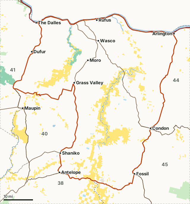
National park land (no hunting)BLMODFW landState forest and trust landOther public (city, county, parks, military)Unit 43Neighboring unitsLake, reservoir or riverHighway
| ODFW zone | Columbia |
|---|---|
| Size | 1,263,612 acres (1,974 square miles) |
| Public land | 12.3% (155,949 acres) |
| Pronghorn harvested, 2025 | 12 (9 bucks) |
| Pronghorn hunters, 2025 | 19, 43 days |
| Pronghorn per 100 hunters, 2025 | 63 |
| Season type | Controlled hunts only |
| 2026 controlled hunts listed here | 2 |
| Towns in and near it | Rufus, Wasco, Condon and Fossil |
How many pronghorn are harvested in Unit 43?
ODFW's pronghorn harvest for the Biggs Unit by year: 12 in 2025, 9 in 2024 and 7 in 2023. 63 pronghorn were taken for every 100 hunters in 2025.
| Year | Hunters | Days hunted | Pronghorn harvested | Bucks | Does | Pronghorn per 100 hunters |
|---|---|---|---|---|---|---|
| 2025 | 19 | 43 | 12 | 9 | 3 | 63 |
| 2024 | 18 | 36 | 9 | 6 | 3 | 50 |
| 2023 | 17 | 34 | 7 | 2 | 5 | 41 |
| 2022 | 12 | 27 | 6 | 1 | 5 | 50 |
| 2021 | 18 | 39 | 13 | 6 | 7 | 72 |
| 2020 | 30 | 71 | 19 | 10 | 9 | 63 |
Source: ODFW harvest statistics (2020 to 2025), from ODFW's mandatory harvest reporting. Each year adds up ODFW's rows for the unit across its pronghorn summaries, general and controlled. A hunter counted on two tag types is counted twice. Per 100 hunters is worked out from ODFW's two figures.
Which pronghorn hunts were used in Unit 43 in 2025?
Controlled hunts: 2 rows in ODFW's table, 19 hunters, 12 pronghorn. ODFW's own row for each, 2025:
| Hunt or season | Tag type | Hunters | Days | Harvested | ODFW success |
|---|---|---|---|---|---|
| 440A1 Columbia Plateau No. 1 | Pronghorn, controlled | 10 | 22 | 3 | 29% |
| 440A2 Columbia Plateau No. 2 | Pronghorn, controlled | 9 | 21 | 9 | 100% |
Source: ODFW's 2025 pronghorn harvest summaries (ODFW harvest statistics (2025)). A hunt that spans several units is split by unit in ODFW's tables; these are the Biggs rows.
When is pronghorn season in Unit 43 in 2026?
Every Oregon pronghorn hunt is a controlled hunt drawn in ODFW's 400 series (pages 60-61).
Controlled pronghorn hunts in ODFW's 2026 tables that include the unit, with ODFW's 2026 tags and its June 2026 draw (residents who drew, of residents who put the hunt first):
| Hunt | Name | Bag limit | 2026 season | 2026 tags | 2026 draw, residents |
|---|---|---|---|---|---|
| 440A1 | Columbia Plateau No. 1 | One doe or fawn pronghorn | Oct. 17 - Oct. 25 | 55 | 54 of 105 |
| 440A2 | Columbia Plateau No. 2 | One buck pronghorn | Oct. 17 - Oct. 25 | 26 | 25 of 380 |
Source: ODFW 2026 Oregon Big Game Hunting Regulations, pages 60 to 61; draw: ODFW's 2026 Preference Point Draw Reports. Hunts are matched to the unit by ODFW's own harvest rows. Check ODFW before you go; seasons can change.
How much public land is in Unit 43?
12.3% of the Biggs Unit is public land open to hunting under its manager's rules: 155,949 of 1,263,612 acres. The largest share is BLM, 146,020 acres.
| Manager | Acres | Share of unit |
|---|---|---|
| BLM | 146,020 | 11.6% |
| ODFW land | 8,377 | 0.7% |
| Other public (city, county, parks, military) | 2,547 | 0.2% |
| State forest and trust land | 1,552 | 0.1% |
| National park land (no hunting) | 1,007 | 0.1% |
ODFW wildlife area in the unit: Lower Deschutes (18,696 acres here).
Measured by FilledTag inside ODFW's unit boundary from USGS PAD-US 4.1 (fee land by manager, 2025). Tribal and private land are not counted as public.
How do you get to Unit 43?
Highways through the unit: US 30 (about 100 miles inside it), I-84 (about 100 miles inside it), OR 206 (about 97 miles inside it), US 97 (about 73 miles inside it) and US 197 (about 20 miles inside it). Towns inside: Rufus, Wasco, Condon, Grass Valley and Shaniko.
Which units border Unit 43?
The Biggs Unit touches 5 other units. Their public land and ODFW's latest pronghorn figures, for comparison:
| Unit | Public land | Pronghorn hunters | Pronghorn harvested | Year |
|---|---|---|---|---|
| Unit 38 Grizzly | 27.1% | 4 | 3 | 2025 |
| Unit 40 Maupin | 9.3% | 1 | 0 | 2025 |
| Unit 41 White River | 43.4% | |||
| Unit 44 Columbia Basin | 1.3% | 31 | 18 | 2025 |
| Unit 45 Fossil | 15.3% | 18 | 6 | 2025 |
Also for Unit 43: elk hunting, deer hunting.
Questions hunters ask
Can you hunt pronghorn in Unit 43 without drawing a tag?
No. In 2026 every pronghorn hunt in the Biggs Unit is a controlled hunt drawn by ODFW. ODFW lists 2 controlled hunts for it in the 2026 regulations.
How many pronghorn are taken in Unit 43 each year?
ODFW estimates 12 in 2025, 9 in 2024 and 7 in 2023, adding up its rows for the Biggs Unit across general and controlled pronghorn tags.
How hard is it to draw hunt 440A1?
In ODFW's 2026 draw for hunt 440A1 (Columbia Plateau No. 1), 54 of 105 residents who put it first drew; the fewest points a resident drew with in the preference phase was 2. ODFW gives 75% of the tags to the most preference points and draws 25% at random among first-choice applicants.
What is the closest town to Unit 43?
Rufus, Wasco and Condon are inside the unit. Just outside: Fossil (on the line), Arlington (on the line) and Dufur (on the line).
Get an Oregon hunt plan when they open
Hunt plans for Oregon are coming. Join the list and you'll hear first. The first 50 hunters in each new state get their plan free.
Until then, the free FilledTag app for iPhone has a map that works in every state, Oregon included.
Where these numbers come from
- Harvest, hunters and days: ODFW harvest statistics (2020 to 2025).
- Seasons, hunts, tags and bag limits: ODFW 2026 Oregon Big Game Hunting Regulations. Draw: ODFW 2026 Preference Point Draw Reports.
- Public land: USGS PAD-US 4.1 (fee land by manager, 2025). Unit boundary: ODFW Wildlife Management Units (Compass dataset).
- Highways, water and towns: U.S. Census Bureau TIGER/Line 2024 and the 2024 Gazetteer.
FilledTag is not part of Oregon Department of Fish and Wildlife. Numbers are copied from ODFW and USGS, or measured from their maps; nothing on this page is estimated by FilledTag.
Oregon hunting Columbia zone Unit 44 pronghorn Unit 45 pronghorn