Summer Lake Wildlife Area: hunting rules, map and access
Summer Lake Wildlife Area is 20,091 acres of land managed by Oregon Department of Fish and Wildlife, in the Wagontire Unit (73) and Silver Lake Unit (76), by ODFW's mapped boundary. ODFW's 2026 rule for the area begins: "Portions of the Area are open to public access and hunting during authorized big game and game bird hunting seasons."
Data updated October 2026. Rules: ODFW's 2026 regulations, page 89. Boundary: ODFW. Land around it: USGS PAD-US 4.1.
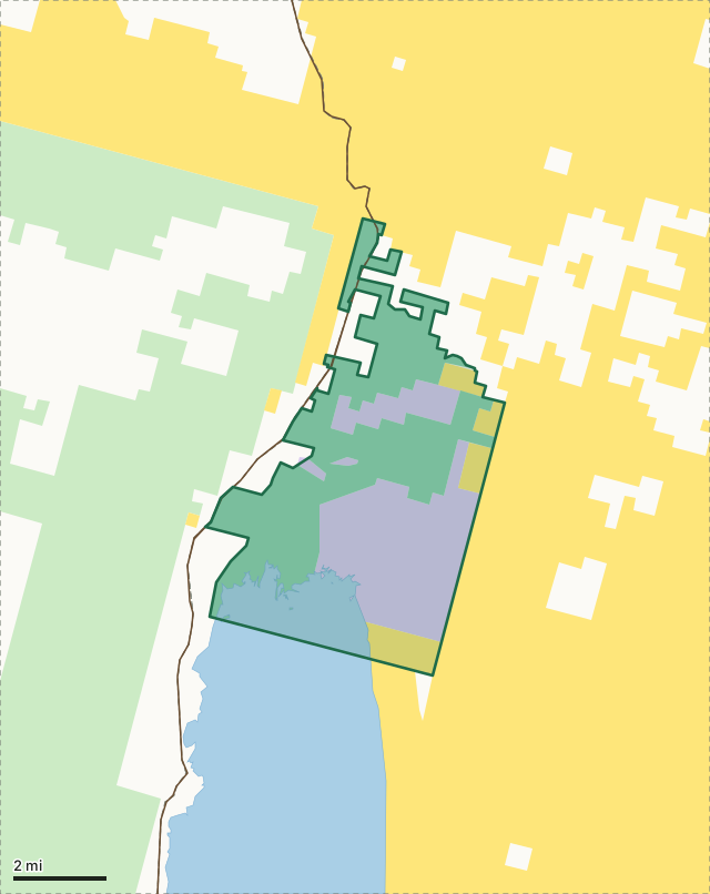
National wildlife refugeNational forestBLMODFW landState forest and trust landSummer Lake Wildlife AreaUnit lineLake, reservoir or riverHighway
| Size | 20,091 acres (ODFW boundary, measured) |
|---|---|
| Units | 73 Wagontire, 76 Silver Lake |
| ODFW zone | Southeast |
| First rule | Portions of the Area are open to public access and hunting during authorized big game and game bird hunting seasons |
| Nearest towns | Silver Lake (15 mi) and Paisley (16 mi) |
What is Summer Lake Wildlife Area?
Summer Lake Wildlife Area was established in 1944, with primary objectives of protecting and improving waterfowl habitat and providing a public hunting area. It is now a popular destination for hunting, wildlife viewing and environmental education due to its geographic setting, the abundance of wildlife present and species diversity.
From ODFW's Summer Lake Wildlife Area page.
What are the hunting rules on Summer Lake Wildlife Area?
Portions of the Area are open to public access and hunting during authorized big game and game bird hunting seasons. It is unlawful to discharge firearms except during game mammal and game bird hunting seasons. Centerfire rifles and handguns are prohibited for game mammal hunting east of Hwy 31. Closed to game mammal hunting with firearms during any pheasant, quail or waterfowl hunting seasons east of State Hwy. 31 and posted refuges areas are closed to hunting. Motorized vehicle travel restricted to open rds and some rds may be closed prior to and during waterfowl hunting seasons. Hunters must obtain a daily hunting permit. Check out at the end of the day or following two consecutive days is required. Permits and area maps are available at Headquarters (1.1 mi south of the town of Summer Lake). ODFW parking permit is required (see pg 89 for more information). Please note: The area south of Thousand Springs Lane (Lake Co. Road 4-17), except the Foster Place unit and specified open rds and campgrounds may be closed to access seven days prior to general waterfowl hunting seasons.
ODFW's 2026 Oregon Big Game Hunting Regulations, page 89, under unit 73. ODFW 2026 Oregon Big Game Hunting Regulations.
Which hunting units is Summer Lake Wildlife Area in?
Summer Lake spans 2 units. ODFW's latest elk and deer harvest for the whole unit, not the wildlife area alone:
| Unit | Wildlife area acres in it | Elk harvested (unit) | Deer harvested (unit) |
|---|---|---|---|
| Unit 73 Wagontire | 19,678 | 16 (2025) | 49 (2025) |
| Unit 76 Silver Lake | 413 | 13 (2025) | 222 (2025) |
Harvest: ODFW harvest statistics (2020 to 2025). Acres in each unit measured by FilledTag from ODFW's boundaries.
How do you get to Summer Lake Wildlife Area?
Highways within 8 miles: OR 31. Nearest towns: Silver Lake (15 miles) and Paisley (16 miles).
Questions hunters ask
Can you hunt on Summer Lake Wildlife Area?
ODFW's 2026 regulations set these rules for Summer Lake: Portions of the Area are open to public access and hunting during authorized big game and game bird hunting seasons. It is unlawful to discharge firearms except during game mammal and game bird hunting seasons. Hunting seasons follow the unit the ground is in.
Which unit is Summer Lake Wildlife Area in?
The Wagontire Unit (73, 19,678 acres) and the Silver Lake Unit (76, 413 acres), by ODFW's boundaries.
What towns are near Summer Lake Wildlife Area?
Silver Lake (15 miles) and Paisley (16 miles), measured to the area's edge.
Get an Oregon hunt plan when they open
Hunt plans for Oregon are coming. Join the list and you'll hear first. The first 50 hunters in each new state get their plan free.
Until then, the free FilledTag app for iPhone has a map that works in every state, Oregon included.
Where these facts come from
- Rules: ODFW 2026 Oregon Big Game Hunting Regulations, page 89.
- Boundary and acres: ODFW Wildlife Areas (Compass dataset). Surrounding public land: USGS PAD-US 4.1 (fee land by manager, 2025).
- Unit harvest: ODFW harvest statistics (2020 to 2025).
FilledTag is not part of Oregon Department of Fish and Wildlife.