Oregon's Southeast zone: hunting units, harvest and public land
ODFW's Southeast zone has 9 wildlife management units and is 79.9% public land, by USGS PAD-US. Adding up ODFW's rows for its units, hunters took 594 elk and 1,870 deer here in 2025, and 783 pronghorn.
Data updated October 2026. Harvest: ODFW, 2020 to 2025. Land: USGS PAD-US 4.1. Seasons: ODFW's 2026 regulations.
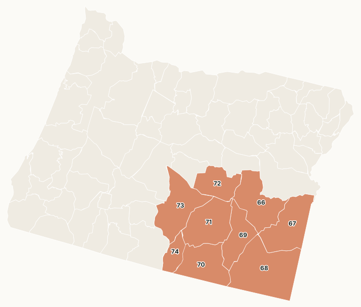
ODFW's Southeast zone is Oregon's high desert: the Malheur River, Owyhee, Whitehorse, Steens Mountain, Beatys Butte, Juniper, Silvies, Wagontire and Warner units, much of it BLM land.
Which units are in the Southeast zone?
Every unit in the zone with ODFW's 2025 harvest and its public land. The most elk were taken in Unit 66 Malheur River (266), Unit 72 Silvies (177) and Unit 67 Owyhee (90). The most public land: Unit 68 (90.4%), Unit 71 (88.7%) and Unit 73 (84.6%).
| Unit | Name | Square miles | Public land | Elk, 2025 | Deer, 2025 | Pronghorn, 2025 |
|---|---|---|---|---|---|---|
| Unit 66 | Malheur River | 2,896 | 67.7% | 266 | 490 | 146 |
| Unit 67 | Owyhee | 3,024 | 80.2% | 90 | 295 | 47 |
| Unit 68 | Whitehorse | 4,892 | 90.4% | 19 | 164 | 118 |
| Unit 69 | Steens Mountain | 1,913 | 63.7% | 10 | 189 | 71 |
| Unit 70 | Beatys Butte | 2,630 | 82.5% | 0 | 63 | 157 |
| Unit 71 | Juniper | 2,925 | 88.7% | 6 | 53 | 51 |
| Unit 72 | Silvies | 1,792 | 66.9% | 177 | 463 | 55 |
| Unit 73 | Wagontire | 3,114 | 84.6% | 16 | 49 | 31 |
| Unit 74 | Warner | 923 | 69.7% | 10 | 104 | 107 |
Harvest: ODFW harvest statistics (2020 to 2025), ODFW's rows for each unit added up across general and controlled tags. Public land measured by FilledTag from USGS PAD-US 4.1 (fee land by manager, 2025).
Controlled hunts in the Southeast zone with their own page
45 hunts with three or more years of ODFW harvest and a 2026 draw report, most tags first:
- 272R Silvies Unit Bow, elk, 755 tags
- 278A1 High Desert No. 1, elk, 440 tags
- 278A2 High Desert No. 2, elk, 440 tags
- 266R N Malheur Rvr Bow, elk, 425 tags
- 266X N Malheur Rvr No. 1, elk, 358 tags
- 266Y N Malheur Rvr No. 2, elk, 358 tags
- 272X Silvies Unit No. 1, elk, 358 tags
- 272Y Silvies Unit No. 2, elk, 358 tags
- 200R Oregon Youth Bow, elk, 330 tags
- 272A Silvies Unit, elk, 330 tags
- 266B N Malheur Rvr, elk, 275 tags
- 266C S Malheur Rvr, elk, 165 tags
- 271A1 Silvies - N Juniper No. 1, elk, 138 tags
- 278M High Desert Muzzleloader, elk, 138 tags
- 468 Whitehorse Unit, pronghorn, 129 tags
- 266A1 Drewsey Valley No. 1, elk, 121 tags
- 271A2 Silvies - N Juniper No. 2, elk, 110 tags
- 466A1 Malheur Rvr Unit No. 1, pronghorn, 88 tags
- 466A2 Malheur Rvr Unit No. 2, pronghorn, 86 tags
- 267 Owyhee Unit, elk, 83 tags
- 268 Whitehorse Unit, elk, 83 tags
- 470A Beatys Butte No. 1, pronghorn, 77 tags
- 469A Steens Mtn, pronghorn, 75 tags
- 470B Beatys Butte No. 2, pronghorn, 74 tags
- 471A Juniper, pronghorn, 63 tags
- 274X Warner Unit No. 1, elk, 55 tags
- 274Y Warner Unit No. 2, elk, 55 tags
- 466R Malheur Rvr Unit Bow, pronghorn, 55 tags
- 467 Owyhee Unit, pronghorn, 55 tags
- 474A Warner Unit No. 1, pronghorn, 53 tags
- 474B Warner Unit No. 2, pronghorn, 53 tags
- 266A2 Drewsey Valley No. 2, elk, 44 tags
- 467R Owyhee Unit Bow, pronghorn, 44 tags
- 472A1 Silvies Unit No. 1, pronghorn, 42 tags
- 472A2 Silvies Unit No. 2, pronghorn, 42 tags
- 470R Beatys Butte Bow, pronghorn, 39 tags
- 474R Warner Unit Bow, pronghorn, 38 tags
- 466B Harney Basin, pronghorn, 33 tags
- 469M Steens Mtn Muzzleloader, pronghorn, 33 tags
- 472B Riley, pronghorn, 28 tags
- 470R1 Hart Mtn Bow, pronghorn, 22 tags
- 266T N Malheur Rvr Youth, elk, 11 tags
- 272T Silvies Unit Youth, elk, 11 tags
- 278T High Desert Youth, elk, 11 tags
- 473M Wagontire Unit Muzzleloader, pronghorn, 11 tags
Wildlife areas and access areas in the Southeast zone
- Summer Lake Wildlife Area: 20,091 acres
- Riverside Wildlife Area: 4,077 acres
- MacKenzie Access Area: 11,083 acres
- Lawen Access Area: 4,196 acres
- Otley Access Area: 15,338 acres
- Pine Creek Access Area: 11,995 acres
- Bentz Access Area: 4,146 acres
- Kueny Access Area: 5,934 acres
- Alvord Access Area: 3,522 acres
Get an Oregon hunt plan when they open
Hunt plans for Oregon are coming. Join the list and you'll hear first. The first 50 hunters in each new state get their plan free.
Until then, the free FilledTag app for iPhone has a map that works in every state, Oregon included.
Sources: ODFW harvest statistics (2020 to 2025); USGS PAD-US 4.1 (fee land by manager, 2025); ODFW Wildlife Management Units (Compass dataset); ODFW 2026 Oregon Big Game Hunting Regulations. FilledTag is not part of Oregon Department of Fish and Wildlife.
Oregon hunting Northwest Southwest Central Columbia Northeast South Central