State Game Lands 73: hunting, parking and access
State Game Lands 73 is 20,814 acres owned by the Pennsylvania Game Commission in Bedford County, Blair County and Huntingdon County, inside WMU 4A. PGC's maps show 42 parking areas, 28 gates and 10 miles of game land road that PGC opens to vehicles at set times of year. The game lands are in 6 separate pieces; the largest is 16,783 acres.
Data updated October 2026. Boundary, parking, roads and gates: PGC's game lands maps. Seasons: PGC 2026-27 Seasons and Bag Limits.
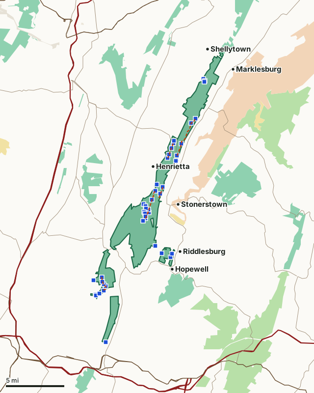
State game landsState forestState parkNational Park ServiceArmy Corps of EngineersMilitary (closed unless the base allows)SGL 73PGC parkingRoad open seasonallyWMU lineHighway
| Size | 20,814 acres, measured from PGC's boundary |
|---|---|
| Counties | Bedford, Blair and Huntingdon |
| WMU | WMU 4A |
| PGC region | Southcentral Region (office in Huntingdon) |
| Parking areas | 42 (21 grass, 19 gravel and 2 dirt) |
| Roads open seasonally | 10 miles on 6 roads |
| Game land roads closed to public vehicles | 25 miles |
| Gates | 28 |
| Separate tracts | 6 (largest 16,783 acres) |
| Nearest towns | Hopewell (next to it), Henrietta (next to it) and Riddlesburg (next to it) |
Where do you park on SGL 73?
PGC maps 42 parking areas on State Game Lands 73, listed north to south. Surfaces: 21 grass, 19 gravel and 2 dirt.
| Lot | Latitude, longitude | Surface | Size (square feet) |
|---|---|---|---|
| 1 | 40.37199, -78.21699 | gravel | 3,200 |
| 2 | 40.36969, -78.21505 | grass | 4,200 |
| 3 | 40.36858, -78.21533 | grass | 2,925 |
| 4 | 40.32220, -78.22982 | grass | 24,700 |
| 5 | 40.31678, -78.23630 | grass | 7,500 |
| 6 | 40.29502, -78.26397 | grass | 9,000 |
| 7 | 40.29161, -78.26536 | gravel | 7,225 |
| 8 | 40.29116, -78.25199 | grass | 20,000 |
| 9 | 40.28574, -78.26804 | gravel | 2,400 |
| 10 | 40.27773, -78.27210 | gravel | 2,500 |
| 11 | 40.27621, -78.25943 | grass | 8,000 |
| 12 | 40.27334, -78.27418 | gravel | 5,000 |
| 13 | 40.26989, -78.26068 | gravel | 9,000 |
| 14 | 40.24002, -78.29157 | gravel | 4,800 |
| 15 | 40.23694, -78.28201 | grass | 3,200 |
| 16 | 40.23247, -78.29430 | gravel | 2,850 |
| 17 | 40.22846, -78.28576 | grass | 1,800 |
| 18 | 40.22122, -78.29953 | dirt | 4,500 |
| 19 | 40.21574, -78.31284 | grass | 15,500 |
| 20 | 40.21296, -78.30989 | grass | 4,400 |
| 21 | 40.21033, -78.30911 | grass | 3,400 |
| 22 | 40.20874, -78.30527 | dirt | 6,300 |
| 23 | 40.20561, -78.31177 | grass | 3,025 |
| 24 | 40.20511, -78.30449 | gravel | 4,900 |
| 25 | 40.20378, -78.31050 | grass | 4,800 |
| 26 | 40.20037, -78.30993 | grass | 4,000 |
| 27 | 40.19781, -78.30979 | gravel | 10,400 |
| 28 | 40.19486, -78.31373 | gravel | 4,250 |
| 29 | 40.16398, -78.29340 | gravel | 4,400 |
| 30 | 40.15450, -78.26602 | gravel | 1,125 |
| 31 | 40.15447, -78.28284 | gravel | 1,728 |
| 32 | 40.14978, -78.26834 | gravel | 1,500 |
| 33 | 40.12410, -78.37997 | gravel | 2,400 |
| 34 | 40.12013, -78.39305 | grass | 48,300 |
| 35 | 40.11884, -78.37844 | grass | 3,000 |
| 36 | 40.11573, -78.37665 | grass | 5,100 |
| 37 | 40.11329, -78.37320 | grass | 4,900 |
| 38 | 40.10754, -78.37658 | gravel | 5,500 |
| 39 | 40.10424, -78.38311 | grass | 1,500 |
| 40 | 40.10265, -78.38994 | gravel | 2,580 |
| 41 | 40.10128, -78.38858 | gravel | 5,768 |
| 42 | 40.04336, -78.37248 | grass | 3,168 |
Source: PGC State Game Lands parking areas. Sizes and surfaces are PGC's own records; a lot may be plowed or not in winter.
Which roads on SGL 73 are open to vehicles?
PGC opens 6 roads on SGL 73 to vehicles at set times of year, 10 miles in all. Outside those times they are closed to public vehicles.
| Road | Miles | When PGC opens it |
|---|---|---|
| Harvey's Rd | 3.8 | Schedule 1 below |
| Sand Flat Rd | 2.5 | Schedule 2 below |
| Snake Spring Access Rd | 1.4 | Schedule 2 below |
| Bench Rd | 1.4 | Schedule 1 below |
| Homans Corner Sale Rd | 1.0 | Schedule 1 below |
| Desert Storm Haul Rd | 0.1 | Schedule 2 below |
Schedule 1, PGC's words: "Opened from 2 weeks prior to the Fall Archery Season until the end of the Flintlock Season in January. Opened for Youth and Spring Gobbler Season."
Schedule 2, PGC's words: "Opened from 2 weeks prior to the Fall Archery Season until the end of the Flintlock Season in January."
PGC also maps 25 miles of game land road on SGL 73 that is closed to public vehicles. PGC's road layer counts 15 miles of road open to public traffic through or along the game lands. PGC records 28 gates here.
PGC marks 2 disabled person routes on SGL 73 (6.3 miles), for hunters who hold PGC's disabled person permit.
Sources: PGC State Game Lands roads; PGC State Game Lands gates; PGC State Game Lands trails. Road miles measured by FilledTag from PGC's lines.
Which WMU is SGL 73 in, and what is taken there?
SGL 73 lies wholly in WMU 4A. Seasons, antlerless licenses and harvest are kept by WMU, not by game lands; these are the figures for each whole WMU:
| WMU | Game lands acres in it | Antlered deer | Antlerless deer | Bears |
|---|---|---|---|---|
| WMU 4A | 20,814 | 5,005 (2025-26) | 8,523 (2025-26) | 71 (2024) |
In WMU 4A, 2026-27 archery deer runs October 3 to November 20, and December 26 to January 24, 2027 and the regular firearms season November 28 to December 13.
Harvest: PGC Annual Deer Population Report, April 2026; PGC's 2024 bear harvest release. Seasons: PGC 2026-27 Seasons and Bag Limits.
How do you get to SGL 73?
Highways through the game lands: PA 164. Highways within five miles: PA 26, US 30, PA 866, I-76, I-70 and PA 36. Nearest towns: Hopewell (next to it), Henrietta (next to it), Riddlesburg (next to it) and Shellytown (next to it).
PGC's land records for SGL 73: PGC real estate, SGL 73.
PGC's rules for every State Game Lands tract, from tree stands to fluorescent orange for non-hunters, are on the Pennsylvania hunting page.
Questions hunters ask
Where can you park on State Game Lands 73?
PGC maps 42 parking areas on SGL 73: 21 grass, 19 gravel and 2 dirt. The largest PGC lists is about 48,300 square feet, at 40.1201, -78.3931. Every lot's coordinates are in the table on this page.
What WMU is State Game Lands 73 in?
All of SGL 73 is in WMU 4A. PGC estimates 5,005 antlered and 8,523 antlerless deer were taken in the whole WMU in 2025-26.
When are the roads on SGL 73 open to vehicles?
PGC lists 6 roads on SGL 73 as open seasonally, 10 miles in all. For Harvey's Rd, PGC's note reads: "Opened from 2 weeks prior to the Fall Archery Season until the end of the Flintlock Season in January. Opened for Youth and Spring Gobbler Season."
Can you camp on State Game Lands 73?
No. PGC does not allow camping on any State Game Lands, SGL 73 included. The nearest town is Hopewell, next to the game lands, by the Census map of places.
Get a Pennsylvania hunt plan when they open
Hunt plans for Pennsylvania are coming. Join the list and you'll hear first. The first 50 hunters in each new state get their plan free.
Until then, the free FilledTag app for iPhone has a map that works in every state, Pennsylvania included.
Where these facts come from
- Boundary and acres: PGC State Game Lands boundaries. Parking: PGC State Game Lands parking areas. Roads: PGC State Game Lands roads. Gates: PGC State Game Lands gates.
- WMU harvest: PGC Annual Deer Population Report, April 2026; PGC's 2024 bear harvest release. Seasons: PGC 2026-27 Seasons and Bag Limits.
- Public land around the game lands: USGS Protected Areas Database of the United States (PAD-US 4.1). Highways and towns: U.S. Census Bureau TIGER/Line 2024 primary and secondary roads; U.S. Census Bureau 2024 Gazetteer, places.
FilledTag is not part of the Pennsylvania Game Commission.