Great Swamp Management Area: deer harvest, seasons and map
Hunters took 24 deer on Great Swamp Management Area in the 2025-26 season, against 18 in 2024-25, by RIDEM's harvest-by-property table. It is 3,585 acres of RIDEM state hunting land in Deer Management Zone 1, number 5 among the state hunting areas with a page.
Data updated October 2026. Harvest: RIDEM 2025-26 Deer Program Report, Table 3. Area: RIDEM State Hunting Land. Seasons: RIDEM 2026-2027 Rhode Island Hunting and Trapping Regulation Guide.
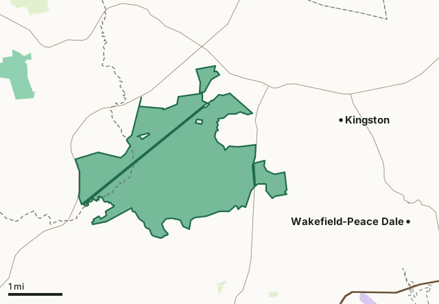
State hunting landOther RIDEM recreation landNational wildlife refugeGreat Swamp Management AreaZone lineHighway
| Size | 3,585 acres (RIDEM) |
|---|---|
| Deer Management Zone | Zone 1 |
| Deer taken, 2025-26 | 24 |
| Deer taken, 2024-25 | 18 |
| RIDEM hunting maps | Great Swamp - East (PDF), Great Swamp - West (PDF) |
| Antlerless bag in the zone | 3 antlerless deer |
| Nearest towns | Kingston (next to it), Carolina (2 mi) and Wakefield-Peace Dale (2 mi) |
How many deer are taken on Great Swamp Management Area?
| Part in RIDEM's table | Deer, 2025-26 | Deer, 2024-25 |
|---|---|---|
| Great Swamp Management Area | 24 | 18 |
Sources: RIDEM 2025-26 Deer Program Report, Table 3; RIDEM 2024-25 Deer Program Report, Table 3. Each table's property rows add up to its statewide total.
When can you hunt Great Swamp Management Area in 2026-27?
| Season | Dates, 2026-27 |
|---|---|
| Archery (youth only) | September 12 to 13 |
| Archery | September 15 to January 31, 2027 |
| Muzzleloader (youth only) | October 31 to November 1 |
| Muzzleloader | November 7 to December 4 |
| Shotgun | December 5 to 31 |
Bag limit in Zone 1: 3 antlerless deer; no more than 2 antlered deer a year in all zones together.
Source: RIDEM 2026-2027 Rhode Island Hunting and Trapping Regulation Guide.
Which state hunting areas are near Great Swamp Management Area?
| State hunting area | Miles away | Deer, 2025-26 | Deer, 2024-25 | Zone |
|---|---|---|---|---|
| South Shore Management Area | 5 | 9 | 14 | Zone 1 |
| Carolina Management Area | 6 | 17 | 18 | Zone 2 |
| Black Farm Management Area | 7 | 4 | 7 | Zone 2 |
| Burlingame Management Area | 8 | 25 | 26 | Zone 1 |
Distances between the areas' centres, measured by FilledTag. Deer: RIDEM 2025-26 Deer Program Report, Table 3.
How do you get to Great Swamp Management Area?
Highways within five miles: US 1, RI 2, RI 138, RI 112, RI 108 and RI 110. Nearest towns: Kingston (next to it), Carolina (2 miles), Wakefield-Peace Dale (2 miles) and Narragansett Pier (4 miles). RIDEM's hunting map sheets show its boundaries and parking: Great Swamp - East, Great Swamp - West.
Questions hunters ask
How many deer are taken on Great Swamp Management Area?
24 in 2025-26 and 18 in 2024-25 (RIDEM 2025-26 Deer Program Report, Table 3; RIDEM 2024-25 Deer Program Report). Zone 1 as a whole gave up 915 in 2025-26.
When can you hunt deer on Great Swamp Management Area?
It follows Zone 1's seasons: archery (youth only) September 12 to 13; archery September 15 to January 31, 2027; muzzleloader (youth only) October 31 to November 1; muzzleloader November 7 to December 4; shotgun December 5 to 31 (RIDEM 2026-2027 Rhode Island Hunting and Trapping Regulation Guide).
Is there a hunting map for Great Swamp Management Area?
Yes. RIDEM publishes 2 hunting map sheets for it: Great Swamp - East, Great Swamp - West (RIDEM hunting map downloads).
Get a Rhode Island hunt plan when they open
Hunt plans for Rhode Island are coming. Join the list and you'll hear first. The first 50 hunters in each new state get their plan free.
Until then, the free FilledTag app for iPhone has a map that works in every state, Rhode Island included.
Where these facts come from
- Deer by property: RIDEM 2025-26 Deer Program Report; RIDEM 2024-25 Deer Program Report. Boundary and acres: RIDEM State Hunting Land. Hunting maps: RIDEM hunting map downloads.
- Seasons and bag limits: RIDEM 2026-2027 Rhode Island Hunting and Trapping Regulation Guide.
- Public land around it: RIDEM State Hunting Land and RIDEM's recreation land layer for state land; USGS Protected Areas Database of the United States (PAD-US 4.1) for federal land. Highways and towns: U.S. Census Bureau TIGER/Line 2024 primary and secondary roads; U.S. Census Bureau 2024 Gazetteer, places.
FilledTag is not part of the Rhode Island Department of Environmental Management.