South Dakota Walk-In Areas by county: parcels, acres and rules
FilledTag's count of GFP's 2025 public lands file, less the 2026 removals (October 23, 2026) finds 1,782 Walk-In Area parcels covering 1,371,812 acres in 63 of South Dakota's 66 counties, and 863 CREP parcels covering 126,319 acres in 31. The most Walk-In acres are in Butte County (247,164), Harding County (187,253) and Perkins County (116,312); the most CREP acres are in Brown County (34,884), Day County (24,658) and Marshall County (21,750).
Data updated October 2026. Walk-In Areas, CREP and GPAs: GFP's 2025 public lands file (last modified March 23, 2026) less GFP's 2026 removals, counted October 23, 2026. Rules: GFP's Walk-In Area questions.
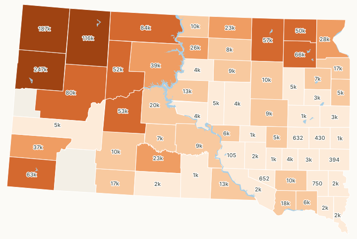
1 to 4,9995,000 to 19,99920,000 to 49,99950,000 to 99,999100,000 acres or moreNoneLake or river
| Walk-In Area parcels | 1,782, 1,371,812 acres |
|---|---|
| CREP parcels | 863, 126,319 acres |
| Counties with Walk-In Areas | 63 of 66 |
| Removed for 2026 | 9 parcels (2,173 acres), 5 more trimmed |
| Game production areas in the same file | 746, 312,257 acres |
| Travel | On foot, except posted designated trails |
Where are South Dakota's Walk-In Areas?
In 63 of the 66 counties. Butte County, Harding County and Perkins County hold 550,729 Walk-In acres between them, 40% of the state's, in 227 parcels averaging 2,426 acres; across the state a Walk-In parcel averages 770 acres and a CREP parcel 146. The most CREP land is in Brown County, Day County and Marshall County. Every county, most Walk-In and CREP acres first:
| County | Walk-In Area parcels | Walk-In Area acres | CREP parcels | CREP acres | Game production areas | GPA acres |
|---|---|---|---|---|---|---|
| Butte County | 43 | 247,164 | 0 | 0 | 3 | 5,103 |
| Harding County | 60 | 187,253 | 0 | 0 | 2 | 1,220 |
| Perkins County | 124 | 116,312 | 0 | 0 | 5 | 7,638 |
| Corson County | 68 | 83,704 | 0 | 0 | 1 | 316 |
| Meade County | 21 | 80,055 | 0 | 0 | 4 | 1,295 |
| Day County | 189 | 41,835 | 158 | 24,658 | 52 | 15,343 |
| Fall River County | 42 | 63,081 | 0 | 0 | 8 | 15,612 |
| Brown County | 102 | 21,759 | 221 | 34,884 | 24 | 12,293 |
| Haakon County | 23 | 52,876 | 0 | 0 | 4 | 1,252 |
| Ziebach County | 23 | 51,962 | 0 | 0 | 2 | 195 |
| Marshall County | 113 | 28,360 | 127 | 21,750 | 39 | 11,812 |
| Dewey County | 29 | 38,663 | 0 | 0 | 3 | 3,540 |
| Custer County | 9 | 37,411 | 0 | 0 | 4 | 2,841 |
| Roberts County | 123 | 27,649 | 6 | 773 | 30 | 6,991 |
| Walworth County | 52 | 26,175 | 0 | 0 | 8 | 5,039 |
| Mellette County | 11 | 23,308 | 0 | 0 | 0 | 0 |
| McPherson County | 51 | 22,267 | 1 | 543 | 20 | 4,772 |
| Stanley County | 15 | 19,649 | 0 | 0 | 8 | 17,234 |
| Bon Homme County | 98 | 17,747 | 7 | 519 | 15 | 6,637 |
| Bennett County | 40 | 16,996 | 0 | 0 | 2 | 2,856 |
| Grant County | 63 | 16,640 | 0 | 0 | 12 | 3,033 |
| Gregory County | 15 | 12,778 | 0 | 0 | 9 | 13,203 |
| Sully County | 34 | 12,596 | 0 | 0 | 18 | 19,598 |
| Campbell County | 37 | 10,445 | 0 | 0 | 8 | 5,654 |
| Jackson County | 17 | 10,135 | 0 | 0 | 0 | 0 |
| Hutchinson County | 21 | 2,198 | 73 | 7,503 | 12 | 2,260 |
| Spink County | 16 | 3,180 | 53 | 6,431 | 14 | 3,451 |
| Faulk County | 7 | 8,200 | 2 | 931 | 5 | 2,248 |
| Lyman County | 22 | 8,756 | 0 | 0 | 14 | 12,726 |
| Beadle County | 12 | 2,594 | 40 | 6,020 | 14 | 3,307 |
| Edmunds County | 21 | 7,442 | 5 | 448 | 11 | 1,980 |
| Codington County | 25 | 5,921 | 11 | 892 | 35 | 9,580 |
| Jones County | 10 | 6,696 | 0 | 0 | 1 | 621 |
| Buffalo County | 1 | 6,197 | 0 | 0 | 1 | 290 |
| Yankton County | 18 | 3,782 | 16 | 1,967 | 11 | 1,801 |
| Deuel County | 28 | 4,008 | 8 | 1,012 | 27 | 5,691 |
| Sanborn County | 4 | 571 | 26 | 4,429 | 11 | 3,165 |
| Pennington County | 7 | 4,770 | 0 | 0 | 5 | 437 |
| Hyde County | 4 | 4,733 | 0 | 0 | 4 | 1,805 |
| Clark County | 20 | 3,674 | 10 | 1,022 | 32 | 11,455 |
| Hanson County | 10 | 1,310 | 25 | 2,925 | 4 | 588 |
| Hand County | 11 | 3,746 | 3 | 436 | 12 | 5,090 |
| Hughes County | 6 | 4,012 | 0 | 0 | 16 | 5,651 |
| Potter County | 7 | 3,348 | 3 | 276 | 6 | 5,247 |
| Hamlin County | 15 | 2,225 | 8 | 900 | 24 | 8,230 |
| Brookings County | 16 | 2,152 | 7 | 612 | 20 | 2,883 |
| McCook County | 6 | 746 | 17 | 1,999 | 12 | 2,931 |
| Todd County | 1 | 2,330 | 0 | 0 | 0 | 0 |
| Union County | 11 | 1,183 | 9 | 1,008 | 10 | 1,054 |
| Aurora County | 2 | 367 | 3 | 1,409 | 11 | 2,320 |
| Clay County | 11 | 1,686 | 0 | 0 | 4 | 623 |
| Lincoln County | 13 | 1,380 | 1 | 275 | 14 | 2,381 |
| Charles Mix County | 11 | 1,602 | 0 | 0 | 19 | 11,762 |
| Kingsbury County | 10 | 1,081 | 1 | 157 | 21 | 8,767 |
| Moody County | 6 | 861 | 4 | 368 | 7 | 735 |
| Davison County | 0 | 0 | 8 | 1,228 | 3 | 437 |
| Jerauld County | 2 | 762 | 4 | 421 | 5 | 1,745 |
| Tripp County | 3 | 1,044 | 0 | 0 | 12 | 1,845 |
| Turner County | 9 | 750 | 0 | 0 | 6 | 1,109 |
| Douglas County | 4 | 398 | 4 | 254 | 0 | 0 |
| Miner County | 2 | 361 | 2 | 271 | 13 | 4,680 |
| Lake County | 4 | 430 | 0 | 0 | 21 | 3,993 |
| Minnehaha County | 2 | 394 | 0 | 0 | 16 | 2,515 |
| Brule County | 2 | 105 | 0 | 0 | 13 | 9,022 |
| Lawrence County | 0 | 0 | 0 | 0 | 6 | 4,261 |
| Oglala Lakota County | 0 | 0 | 0 | 0 | 0 | 0 |
FilledTag's count of GFP's 2025 public lands file, less the 2026 removals (October 23, 2026): each polygon in GFP's file is one parcel, measured in an equal-area projection and counted in the county that holds most of it; GPAs are counted in every county they reach. Sources: GFP, 2025 South Dakota Public Lands file (last modified March 23, 2026), less the 15 removals dated July 22 to October 21, 2026 in GFP's hunting atlas removals layer; U.S. Census Bureau 2024 county lines. Each county's page shows its parcels on a map.
Which Walk-In Areas were removed for 2026?
GFP's removals layer holds 245 areas taken out of its atlas since 2021; 15 are dated after the 2025 file, from July 22, 2026 to October 21, 2026, and cover 3,809 acres. They take out 9 Walk-In Area parcels (2,173 acres) in Buffalo County, Charles Mix County, Day County, Lyman County, Meade County and Walworth County and trim 5 large parcels that stay in the program. No CREP parcel was removed. The file held 1,791 Walk-In Area parcels before the removals.
A parcel counts as removed when half or more of it lies inside a 2026 removal; a parcel with a smaller part removed keeps its other acres. Source: GFP's hunting atlas removals layer, read October 23, 2026.
What are the rules on a South Dakota Walk-In Area?
- Walk-In Areas, CREP and CHAP land are private land GFP leases for public hunting, not public land.
- Travel is on foot only, unless there is a posted designated trail. E-bikes are not allowed.
- The 660-foot rule for road rights-of-way does not apply: you may hunt a Walk-In Area near anything, cattle included.
- Portable tree stands, portable blinds and climbing devices that use no nails, wire or bolts are allowed from August 1 through March 31; licensed spring turkey hunters may use portable blinds in the spring seasons.
- No trail cameras without the landowner's permission. Night hunting for coyotes needs the landowner's permission and is allowed only January 1 to August 31.
- Lead shot is allowed for small game; nontoxic shot is required for waterfowl.
- Special buck licenses and mentor antelope tags are not valid on Walk-In Areas, CREP or CHAP land.
Source: GFP, Walk-In Area questions (PDF, 2025).
Which Walk-In Areas carry special rules?
Most carry none: 1,308 of the 1,782 Walk-In Area parcels and 838 of the 863 CREP parcels have no restriction in GFP's file. The rest carry one of these in GFP's file:
| Program | GFP's rule | Parcels | Acres |
|---|---|---|---|
| Walk-In Area | Driving on harvested fields allowed for waterfowl decoy placement and disabled hunter permit holders | 381 | 112,877 |
| Walk-In Area | Driving with ATVs/UTVs and trailers on harvested fields allowed for waterfowl decoy placement and disabled hunter permit holders | 37 | 5,449 |
| Walk-In Area | No hunting in unharvested crops | 36 | 9,233 |
| CREP | No hunting in unharvested crops | 14 | 2,037 |
| CREP | No hunting in unharvested crops or while farm machinery is working the field | 10 | 3,049 |
| Walk-In Area | Archery and shotguns using shotshells only | 6 | 861 |
| Walk-In Area | Not open until Nov. 1 | 4 | 409 |
| Walk-In Area | Not open until Oct. 1 | 3 | 7,993 |
| Walk-In Area | No upland gamebird hunting | 2 | 6,522 |
| Walk-In Area | Open Sept. 1 - May 31 | 2 | 5,616 |
| Walk-In Area | Archery, muzzleloaders, and shotguns only | 2 | 341 |
| CREP | Archery and shotguns using shotshells only | 1 | 59 |
| Walk-In Area | Archery only | 1 | 6 |
Source: the "Restriction Desc." field of GFP's 2025 public lands file, less the 2026 removals. Two of the codes allow driving on harvested fields for decoy placement and disabled hunter permit holders; the others limit when or how you may hunt.
How do you find a Walk-In Area?
GFP prints a public hunting atlas each year, free wherever hunting licenses are sold and at GFP offices, and shows the same land on its online maps. Walk-In Areas and CREP land with undisturbed cover such as CRP grass, wetlands and trees have a green outline in the atlas (GFP, Walk-In Area questions (PDF, 2025)). Each county page here lists its parcels: start with Butte County, Harding County, Perkins County and Corson County. For the 2026 pheasant dates, hours and road rules, see the South Dakota pheasant season page.
How are Walk-In Areas paid for?
GFP pays landowners $0.60 to $14 an acre a year, the most for CRP-type cover in high pheasant density areas or near Sioux Falls. 75% of the program's money comes from the federal excise tax on firearms, ammunition and archery gear, and 25% from hunting license sales (GFP, Walk-In Area questions (PDF, 2025)).
Questions hunters ask
Are South Dakota Walk-In Areas public land?
No. They are private farms and ranches GFP leases for public hunting access, so normal farming and ranching goes on while you hunt, by GFP's Walk-In Area questions.
Can you drive or ride an e-bike on a Walk-In Area?
No. Walk-In Areas, CREP and CHAP land are open to foot traffic only, unless there is a posted designated trail, and e-bikes are not allowed, by GFP.
Can you hunt a Walk-In Area with cattle on it?
Yes. GFP says hunters can hunt a Walk-In Area while cattle are present, and the road right-of-way rule against hunting within 660 feet of livestock, dwellings, churches or schools does not apply on Walk-In Areas.
How many Walk-In Areas are in South Dakota?
1,782 Walk-In Area parcels covering 1,371,812 acres, plus 863 CREP parcels covering 126,319 acres, by FilledTag's count of GFP's 2025 public lands file, less the 2026 removals (October 23, 2026).
Get a South Dakota pheasant plan
South Dakota pheasant plans can be ordered now: one county and one day in GFP's traditional season, October 17, 2026 to January 31, 2027, for $9.99. The plan lists patches of pheasant cover on land GFP maps as open to public hunting, each with legal parking on a public road and the walk from the truck, plus GFP's terms for each parcel. Check your hunt first; the check is free. A person looks over every South Dakota pheasant plan before it is sent.
Check my South Dakota pheasant hunt See a real small game plan
The free map works in South Dakota too, on your phone with no signal.
Where these numbers come from
- Walk-In Areas, CREP and game production areas: GFP, 2025 South Dakota Public Lands file (last modified March 23, 2026), less the 15 removals dated July 22 to October 21, 2026 in GFP's hunting atlas removals layer. Areas measured in NAD83 CONUS Albers, an equal-area projection, inside U.S. Census Bureau 2024 county lines.
- Rules: GFP, Walk-In Area questions (PDF, 2025); GFP, Hunting Areas Information (2026).
FilledTag is not part of South Dakota Game, Fish and Parks. Walk-In Areas change each year; GFP's current atlas and the signs on the ground are the final word.
South Dakota hunting South Dakota pheasant season Butte County Harding County Perkins County Corson County Meade County Day County