Keechi Creek WMA: access, drawn hunts and map
Keechi Creek WMA is 1,500 acres in Leon County, owned or managed by TPWD. It has no page in TPWD's 2026-27 Map Booklet for Public Hunting Lands, so the Annual Public Hunting Permit alone does not open it to walk-in hunting. TPWD's page points hunters to drawn or special permit hunts. When it is open, in TPWD's words: Access is limited. Please see the Annual Public Hunting Permit page and Drawn hunt system for hunting access information.
Data updated October 2026. Area facts: TPWD's page for Keechi Creek WMA. Boundary: TPWD's WMA layer.
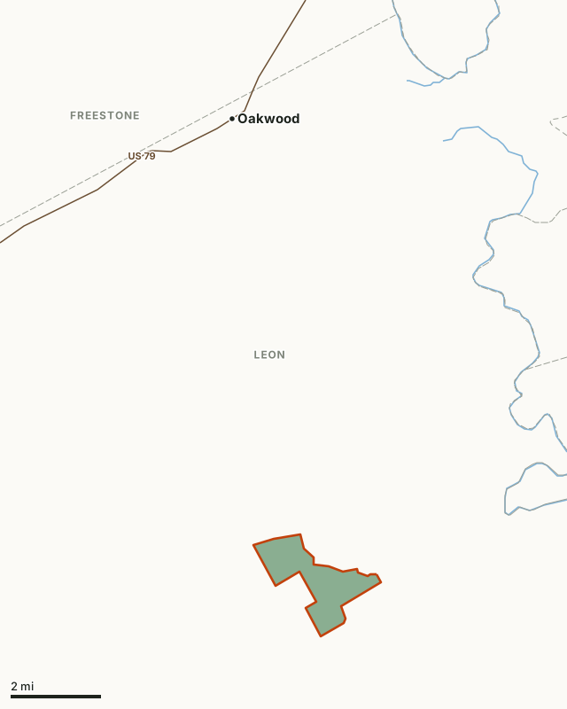
This areaOther public hunting landCounty lineLake or riverHighway
| Size | 1,500 acres (TPWD); 1,490 acres mapped |
|---|---|
| County | Leon County |
| Walk-in hunting on the APH permit | No booklet page for 2026-27 |
| When it is open | Access is limited. Please see the Annual Public Hunting Permit page and Drawn hunt system for hunting access information. |
| Area office | (903) 480-1221 |
| Towns | Oakwood (9 mi), Buffalo (13 mi) and Centerville (15 mi) |
What is Keechi Creek WMA for?
Keechi Creek Wildlife Management Area (KCWMA) is located in northeastern Leon County, and lies within the Post Oak Savannah Ecological Region. The area contains 1,500 acres of mostly bottomland hardwood forest at the confluence of Keechi and Buffalo creeks. KCWMA was purchased by Texas Parks and Wildlife Department (TPWD) in the spring of 1986 with funds provided by the Texas Waterfowl Stamp and from mitigation funds. The acquisition fulfilled the wildlife habitat mitigation obligation of the Brazos River Authority for losses resulting from the construction of Sterling C. Robertson Dam and Lake Limestone on the Navasota River in Robertson and Leon Counties. The area was purchased primarily for the preservation of bottomland hardwoods and for use as a waterfowl management area. It was the first non-coastal waterfowl habitat acquired in part with Texas Waterfowl Stamp funds. KCWMA is a virtual island of bottomland hardwood habitat surrounded by “improved” coastal Bermuda pastures.
The area has a moderate climate with hot summers and moderately cold winters. Because it is a woodland area, the temperatures are somewhat more stable than adjacent open pasturelands. Temperatures range from a maximum in July of 95°F to a minimum in January of 38°F. Nearly all of KCWMA is seasonally flooded in wet years. Alluvial soils on KCWMA are mostly loams. About 90% of the area is wooded, with 10% open (including some brush, saplings, and marshes). Major overstory tree species include willow oak, water oak, overcup oak, and post oak with a few cedar and American elm on the upland transitional zones. Major understory species include flowering dogwood, yaupon, rattanvine, farkleberry, dewberry, greenbriar, wild grape, common trumpet creeper and American beautyberry. The most common grasses include giant cane, switchgrass, rescuegrass and eastern gamagrass. Most of the forbs present are annuals and include giant ragweed, yankeeweed, Levenworth eryngo, black-eyed susan and beggar's ticks. A comprehensive inventory of the Area has not been conducted. Principal wildlife species include (in rough order of generated public use): white tailed deer, feral hog, grey squirrel, waterfowl, and swamp rabbit. Fishing is not permitted on KCWMA because of lack of access. No endangered animals or plants are known to inhabit the area. The State Threatened timber rattlesnake is common on the area.
Hunters interested in small game may hunt on designated days with the Annual Public Hunting Permit and a hunting license. Waterfowl, Multi-species, and Feral hog hunts are available by postcard application. Gun deer hunters are currently selected by drawing in order to provide an enjoyable and safe outdoor experience and help to properly manage the resource.
From TPWD's Keechi Creek WMA page.
Can you hunt Keechi Creek WMA?
Only through TPWD's drawn or special permit hunts, by TPWD's page: Please see the Annual Public Hunting Permit page and Drawn hunt system for hunting access information. Keechi Creek WMA has no page in the 2026-27 Map Booklet for Public Hunting Lands, so the Annual Public Hunting Permit alone does not open it.
TPWD's drawn hunts are listed in its Public Hunt Drawing System, by area and hunt category.
How do you get to Keechi Creek WMA?
Keechi Creek WMA lies in Leon County. Nearest towns: Oakwood (9 miles), Buffalo (13 miles), Centerville (15 miles) and Elkhart (18 miles).
Where can you hunt near Keechi Creek WMA?
The closest places on the Annual Public Hunting Permit with a page of their own:
| Area | County | Distance |
|---|---|---|
| Big Lake Bottom WMA | Anderson | 15.2 mi |
| Gus Engeling WMA | Anderson | 30.7 mi |
| Luminant Texas Public Hunting Land | Robertson | 32.5 mi |
| Richland Creek WMA | Freestone and Navarro | 33.1 mi |
| Sam Houston National Forest WMA | San Jacinto and Walker | 49.5 mi |
| Alabama Creek WMA | Trinity | 51.2 mi |
Questions hunters ask
Can you hunt Keechi Creek WMA?
Only through TPWD's drawn or special permit hunts, by TPWD's page: Please see the Annual Public Hunting Permit page and Drawn hunt system for hunting access information. Keechi Creek WMA has no page in the 2026-27 Map Booklet for Public Hunting Lands, so the Annual Public Hunting Permit alone does not open it.
How big is Keechi Creek WMA?
TPWD gives it as 1,500 acres; FilledTag measures 1,490 acres inside TPWD's WMA boundary.
Where is Keechi Creek WMA?
In Leon County. Nearest towns: Oakwood (9 miles), Buffalo (13 miles) and Centerville (15 miles). TPWD's address for the area: 1670 FM 488, Streetman, TX 75859.
Where is the nearest walk-in public hunting to Keechi Creek WMA?
Big Lake Bottom WMA, 15.2 mi away, on the Annual Public Hunting Permit.
Get a Texas hunt plan when they open
Hunt plans for Texas are coming. Join the list and you'll hear first. The first 50 hunters in each new state get their plan free.
Until then, the free FilledTag app for iPhone has a map that works in every state, Texas included.
Where these facts come from
- Area description, hours and contact: TPWD, Keechi Creek WMA.
- Boundary: TPWD WMA boundaries. Nearby public hunting: TPWD Public Hunt Locator map and TPWD 2026-27 Map Booklet.
- Counties, highways and towns: U.S. Census Bureau TIGER/Line 2024 and Gazetteer.
FilledTag is not part of the Texas Parks and Wildlife Department.