Matagorda Island WMA: public hunting, 2026-27 seasons and access
Matagorda Island WMA is 56,688 acres of public hunting land in Calhoun County, Texas, TPWD unit #722. Adults hunt it on the $48 Annual Public Hunting Permit. TPWD's 2026-27 map booklet lists upland unit and bayside marsh unit as legal game here.
Data updated October 2026. Seasons and rules: TPWD's 2026-27 Map Booklet for Public Hunting Lands. Boundaries: TPWD's Public Hunt Locator map.
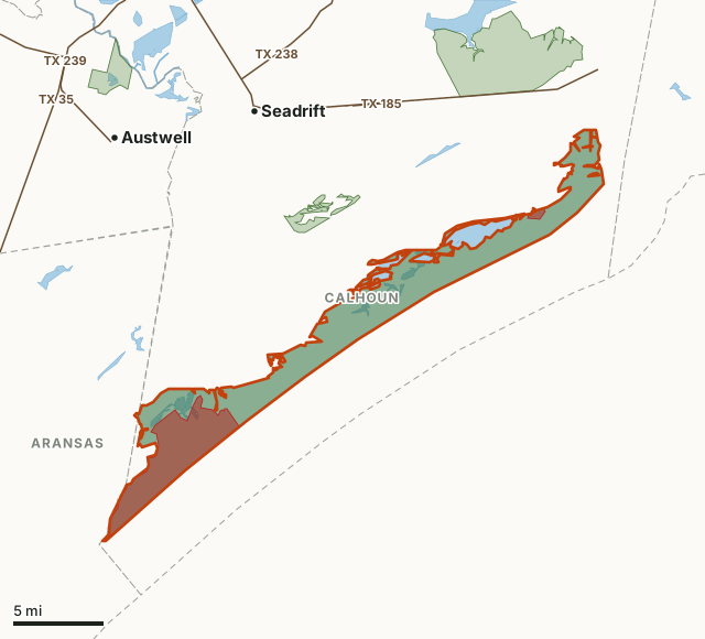
This areaOther public hunting landNo hunting zoneCounty lineLake or riverHighway
| TPWD unit | #722 |
|---|---|
| Size | 56,688 acres (TPWD booklet); 45,355 acres mapped |
| County | Calhoun County |
| Permit | Annual Public Hunting Permit ($48) |
| Owned by | U.S. Fish and Wildlife Service and General Land Office of Texas |
| Legal game listed | Upland Unit and Bayside Marsh Unit |
| Deer | No deer season for walk-in hunters in the booklet |
| White-tailed deer unit | TPWD unit 09 |
| Towns | Seadrift (10 mi), Fulton (11 mi) and Rockport (12 mi) |
| Highways | TX 185 (2.7 mi) |
What can you hunt on Matagorda Island WMA in 2026-27?
TPWD's 2026-27 booklet lists 3 legal game entries for Matagorda Island WMA, none of them deer. Every line below is TPWD's own wording.
| Species or season | What TPWD's 2026-27 booklet says |
|---|---|
| Upland Unit | Only on Dec. 12-13, Jan. 9-10, Jan. 16-17, Jan. 23-24, and Jan. 30-31 provided that these dates occur within the South Zone Duck season dates. Shooting hours end at noon. Hunting of geese is prohibited. There are 17 available hunting sites on the island. Hunter check-in begins at 5:00 am and ends at 5:30 am. All hunters are transported to and from hunt sites by TPWD personnel. Hunters overnight camping on the island will be checked in the night prior to the hunt (e.g. Campers will be checked in Friday night for the Saturday morning hunt period). All other hunters will be checked in beginning at 5:00 am the morning of the hunt period. |
| Bayside Marsh Unit | No APH Permit is required to hunt waterfowl. No check in or registration required. Waterfowl may be taken during the entire South Zone Duck season. Shooting hours are one-half hour before sunrise to sunset. Airboats are permitted within the Bayside Marsh Unit only. |
| Fishing | No APH or LPU is required to fish. |
What are the rules on Matagorda Island WMA?
- Permit and registration: An APH Permit is required to waterfowl hunt in the Upland Unit. An APH or LPU is required to camp in the campground adjacent to the check station. No daily permits will be issued. Bayside Marsh Unit: No APH Permit is required to hunt waterfowl. No check in or registration required. Fishing: No APH or LPU is required to fish.
- Special regulations: Matagorda Island WMA is only accessible by boat and there is no state provided transportation to or from the island. All visitor access is by chartered boat or private boat. The hunter check station is approximately 7 miles across Espiritu Santo Bay from Port O'Connor. Hunters can call the Rockport office at (361) 790-0307 for information. An APH Permit is required to waterfowl hunt in the Upland Unit. An APH or LPU is required to camp in the campground adjacent to the check station. No daily permits will be issued.
- Means restriction: Shotguns with non-toxic shot are the legal means that may be used or possessed during these hunts.
Source: TPWD 2026-27 Map Booklet for Public Hunting Lands, unit #722 (PDF).
Which parts of Matagorda Island WMA are closed or limited?
TPWD's map of Matagorda Island WMA marks no hunting zones and hunting compartments (open to hunting). No hunting zones are closed to all hunting. Hunting compartments are the numbered blocks hunters register for and hunt. Measured inside the boundary from TPWD's own polygons:
| Zone | Acres | Share of Matagorda Island WMA |
|---|---|---|
| No hunting zones | 11,071 | 24.4% |
| Hunting compartments (open to hunting) | 17,805 | 39.3% |
Measured by FilledTag from TPWD's Public Hunt Locator map. Posted signs and the booklet's map are the final word on the ground.
How do you get to Matagorda Island WMA?
Matagorda Island WMA lies in Calhoun County. Nearest towns: Seadrift (10 miles), Fulton (11 miles), Rockport (12 miles) and Austwell (14 miles). Highways within 5 miles: TX 185 (2.7 miles). Water nearby: Big Brundrett Lake and Power Lake.
TPWD's map points for Matagorda Island WMA: 1 info station and 1 camp site.
TPWD's page says: The Matagorda Island Wildlife Management Area (WMA) is open throughout the year for camping, biking, hiking, wildlife viewing and fishing and hunting activities. To camp and to hunt duck on the WMA, visitors must have a Limited Public Use Permit (LPU) or Annual Public Hunting Lands Permit (APH). No permit is needed for day use of the WMA. To get to the WMA is by boat only, see the Matagorda Island Map and the Matagorda Island WMA Headquarters Complex Map. The Sunday Beach area of Matagorda Island is open to the public for activities with no fees, permits or restrictions. TPWD's page gives the area as 56,688 acres. Area office: (361) 205-1510.
From TPWD's Matagorda Island WMA page.
Which deer management unit is Matagorda Island WMA in?
Matagorda Island WMA lies in TPWD white-tailed deer management unit 09. TPWD publishes its harvest survey statewide; across Texas in 2025-26 it estimates 714,424 white-tailed deer hunters took 782,405 deer. The page on Texas public hunting has the statewide table.
Units: TPWD white-tailed deer management units. Harvest: TPWD Big Game Harvest Survey, 2025-26.
What other public hunting is near Matagorda Island WMA?
The closest other places on the Annual Public Hunting Permit with a page of their own, measured edge to edge:
| Area | County | Distance |
|---|---|---|
| Guadalupe Delta WMA | Calhoun and Refugio | 16.4 mi |
| Mad Island WMA | Matagorda | 26 mi |
| Nannie M. Stringfellow WMA | Brazoria | 58.5 mi |
Questions hunters ask
Do you need a permit to hunt Matagorda Island WMA?
Yes. Hunters 17 and older need the $48 Annual Public Hunting Permit along with a Texas hunting license; hunters under 17 may hunt free with a permitted adult. TPWD's booklet adds: An APH Permit is required to waterfowl hunt in the Upland Unit. An APH or LPU is required to camp in the campground adjacent to the check station. No daily permits will be issued. Bayside Marsh Unit: No APH Permit is required to hunt waterfowl. No check in or registration required. Fishing: No APH or LPU is required to fish.
Can you hunt deer on Matagorda Island WMA?
Not on the Annual Public Hunting Permit: TPWD's 2026-27 booklet lists no deer season here.
Can you camp on Matagorda Island WMA?
TPWD's booklet: An APH or LPU is required to camp in the campground adjacent to the check station.
Where is Matagorda Island WMA?
Matagorda Island WMA is in Calhoun County. The nearest towns: Seadrift (10 miles), Fulton (11 miles) and Rockport (12 miles). Highways nearby: TX 185.
Get a Texas hunt plan when they open
Hunt plans for Texas are coming. Join the list and you'll hear first. The first 50 hunters in each new state get their plan free.
Until then, the free FilledTag app for iPhone has a map that works in every state, Texas included.
Where these facts come from
- Legal game, dates, rules, permits and closures: TPWD 2026-27 Map Booklet for Public Hunting Lands, unit #722.
- Boundaries, zones and map points: TPWD Public Hunt Locator map. Acres and distances measured by FilledTag.
- Counties, highways and towns: U.S. Census Bureau TIGER/Line 2024 and Gazetteer. Lakes and rivers: USGS National Hydrography Dataset.
FilledTag is not part of the Texas Parks and Wildlife Department. TPWD's booklet and posted signs are the final word on every rule; nothing on this page is estimated by FilledTag.
Texas public hunting Calhoun County Guadalupe Delta WMA Mad Island WMA Nannie M. Stringfellow WMA