Montgomery County, Virginia: deer and bear hunting, harvest and public land
DWR counted 2,765 deer killed in Montgomery County in the 2025-26 season: 1,323 antlered bucks, 112 button bucks and 1,330 does, along with 29 bears. In 2026-27 the firearms deer season on private land runs November 14 to January 2. 8.7% of the county is public land, the largest share national forest (19,759 acres), by the USGS Protected Areas Database.
Data updated October 2026. Deer: DWR Deer Kill Data. Bears: DWR Black Bear Harvest by County. Seasons: DWR's 2026-27 deer and bear regulations. Land: PAD-US 4.1.
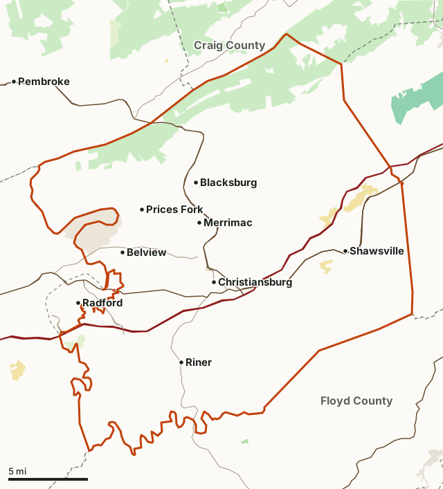
National forestDWR land (WMAs)State forestState parks and natural areas (DCR)National Park ServiceOther state landMilitary (closed unless the base allows)Montgomery CountyNeighboring countiesHighway
| Size | 389 square miles |
|---|---|
| Public land | 8.7% (21,604 acres) |
| Deer killed, 2025-26 | 2,765 (1,323 antlered, 1,330 does) |
| Deer killed per square mile | 7.1 (worked out from DWR's count) |
| Bears killed, 2025 | 29 |
| Firearms deer season, private lands, 2026-27 | November 14 to January 2 |
| Earn a Buck | Yes: an antlerless deer must be taken before a second antlered deer (DWR) |
| National forest firearms season | November 14 to November 28 |
How many deer are killed in Montgomery County?
DWR counted 2,765 deer in Montgomery County in 2025-26, down from 2,848. DWR's table for the county runs back to 1947; the most it shows is 2,942 in 2002. The last 20 seasons:
| Season | Antlered bucks | Button bucks | Does | Total |
|---|---|---|---|---|
| 2025-26 | 1,323 | 112 | 1,330 | 2,765 |
| 2024-25 | 1,347 | 127 | 1,374 | 2,848 |
| 2023-24 | 1,449 | 109 | 1,298 | 2,856 |
| 2022-23 | 1,219 | 124 | 1,155 | 2,498 |
| 2021-22 | 1,176 | 136 | 1,174 | 2,486 |
| 2020-21 | 1,350 | 177 | 1,400 | 2,927 |
| 2019-20 | 1,112 | 131 | 1,210 | 2,453 |
| 2018-19 | 1,180 | 113 | 1,224 | 2,517 |
| 2017-18 | 1,262 | 143 | 1,248 | 2,653 |
| 2016-17 | 1,098 | 136 | 894 | 2,128 |
| 2015-16 | 1,370 | 167 | 1,275 | 2,812 |
| 2014-15 | 1,155 | 151 | 1,014 | 2,321 |
| 2013-14 | 1,290 | 225 | 1,338 | 2,853 |
| 2012-13 | 1,100 | 166 | 1,111 | 2,377 |
| 2011-12 | 1,039 | 126 | 994 | 2,159 |
| 2010-11 | 944 | 137 | 996 | 2,077 |
| 2009-10 | 1,175 | 217 | 1,412 | 2,804 |
| 2008-09 | 1,223 | 218 | 1,405 | 2,846 |
| 2007-08 | 1,310 | 251 | 1,348 | 2,909 |
| 2006-07 | 1,172 | 185 | 955 | 2,312 |
Source: DWR Deer Kill Data, Montgomery. DWR's figure for the latest season is preliminary and leaves out the late urban archery and late antlerless-only seasons.
How many bears are killed in Montgomery County?
DWR counted 29 bears in Montgomery County in 2025.
| Year | Bears |
|---|---|
| 2025 | 29 |
| 2024 | 47 |
| 2023 | 45 |
Source: DWR Black Bear Harvest by County.
When are the 2026-27 seasons in Montgomery County?
| Season | Dates, 2026-27 |
|---|---|
| Deer, early archery (either sex, statewide) | October 3 to November 13 |
| Deer, early muzzleloader (most of the state) | October 31 to November 13 |
| Deer, firearms, private lands | November 14 to January 2 |
| Deer, either-sex days | November 14 through January 2 (full season) |
| Deer, firearms, George Washington and Jefferson National Forest | November 14 to November 28 |
| Deer, either-sex days on the national forest | November 21 and November 28 |
| Bear, archery | October 3 to November 13 |
| Bear, muzzleloader | November 7 to 13 |
| Bear, firearms | November 23 to January 2 |
Sources: DWR Deer Hunting Regulations and Seasons; DWR Bear Hunting Regulations and Seasons, read 2026-10-18. Late archery and late muzzleloader seasons differ by area; DWR's pages list them. Public land other than the national forest and DWR's WMAs follows the private land seasons.
How much public land is in Montgomery County?
8.7% of Montgomery County is public land: 21,604 of its 249,161 acres. The largest share is national forest, 19,759 acres.
| Manager | Acres | Share of Montgomery County |
|---|---|---|
| National forest | 19,759 | 7.9% |
| Military (closed unless the base allows) | 2,303 | 0.9% |
| State parks and natural areas (DCR) | 1,412 | 0.6% |
| Other state land | 433 | 0.2% |
Measured by FilledTag inside the county line from USGS Protected Areas Database of the United States (PAD-US 4.1). Hunting is allowed on most national forest and DWR land; Shenandoah National Park and the Blue Ridge Parkway are closed to it, and state parks allow it only in places.
Which counties border Montgomery County?
| County or city | Public land | Deer, 2025 | Antlered, 2025 | Bears, 2025 |
|---|---|---|---|---|
| Craig County | 55.3% | 1,726 | 910 | 70 |
| Floyd County | 2.4% | 2,967 | 1,326 | 15 |
| Giles County | 29.9% | 2,412 | 1,147 | 63 |
| Pulaski County | 9.6% | 2,324 | 1,115 | 26 |
| Roanoke County | 12.3% | 1,631 | 789 | 37 |
Highways crossing Montgomery County: US 460 (58 miles), I-81 (51 miles), US 11 (32 miles), VA 8 (11 miles), VA 114 (9 miles) and VA 177 (5 miles). Towns inside: Blacksburg and Christiansburg.
Questions hunters ask
How many deer are killed in Montgomery County?
DWR counted 2,765 deer in Montgomery County in 2025-26, against 2,848 the season before. The five-season average to 2025 is 2,691 a year, and the most in DWR's table was 2,942 in 2002, worked out from DWR's figures.
When is deer season in Montgomery County in 2026?
Early archery runs October 3 to November 13 and early muzzleloader October 31 to November 13 in most of the state. The firearms season on private land in Montgomery County runs November 14 to January 2, with either-sex days November 14 through January 2 (full season) (DWR Deer Hunting Regulations and Seasons).
When is bear season in Montgomery County?
In 2026-27: archery October 3 to November 13; muzzleloader November 7 to 13; firearms November 23 to January 2 (DWR Bear Hunting Regulations and Seasons). DWR counted 29 bears in Montgomery County in 2025.
How much public land is in Montgomery County?
21,604 acres, 8.7% of the county, by PAD-US 4.1. National forest: 19,759 acres.
Is Montgomery County an Earn a Buck county?
Yes. DWR marks Montgomery County as an Earn a Buck county for 2026-27: a hunter must take an antlerless deer there before taking a second antlered deer.
Get a Virginia hunt plan when they open
Hunt plans for Virginia are coming. Join the list and you'll hear first. The first 50 hunters in each new state get their plan free.
Until then, the free FilledTag app for iPhone has a map that works in every state, Virginia included.
Where these numbers come from
- Deer: DWR Deer Kill Data. Bears: DWR Black Bear Harvest by County; DWR, 2025-2026 bear, deer and turkey harvest data announced.
- Seasons, either-sex days and Earn a Buck: DWR Deer Hunting Regulations and Seasons; DWR Bear Hunting Regulations and Seasons.
- Boundary: Virginia county and city boundaries (DCR, served by DWR). WMAs: DWR Wildlife Management Areas. Public land: USGS Protected Areas Database of the United States (PAD-US 4.1).
- Highways and towns: U.S. Census Bureau TIGER/Line 2024 primary and secondary roads; U.S. Census Bureau 2024 Gazetteer, places.
FilledTag is not part of the Virginia Department of Wildlife Resources. Numbers are copied from DWR and federal sources, or measured from their maps; nothing on this page is estimated by FilledTag.
Virginia hunting Craig County Floyd County Giles County Pulaski County Roanoke County