Amelia Wildlife Management Area: hunting, parking and access
Amelia Wildlife Management Area is 2,233 acres of Virginia Department of Wildlife Resources land in Amelia County. DWR's maps show 12 parking areas and 13 gates. The 2026-27 firearms deer season on the WMA runs November 14 to January 2.
Data updated October 2026. Boundary, parking, gates and roads: DWR's WMA maps. Seasons: DWR Deer Hunting Regulations and Seasons.
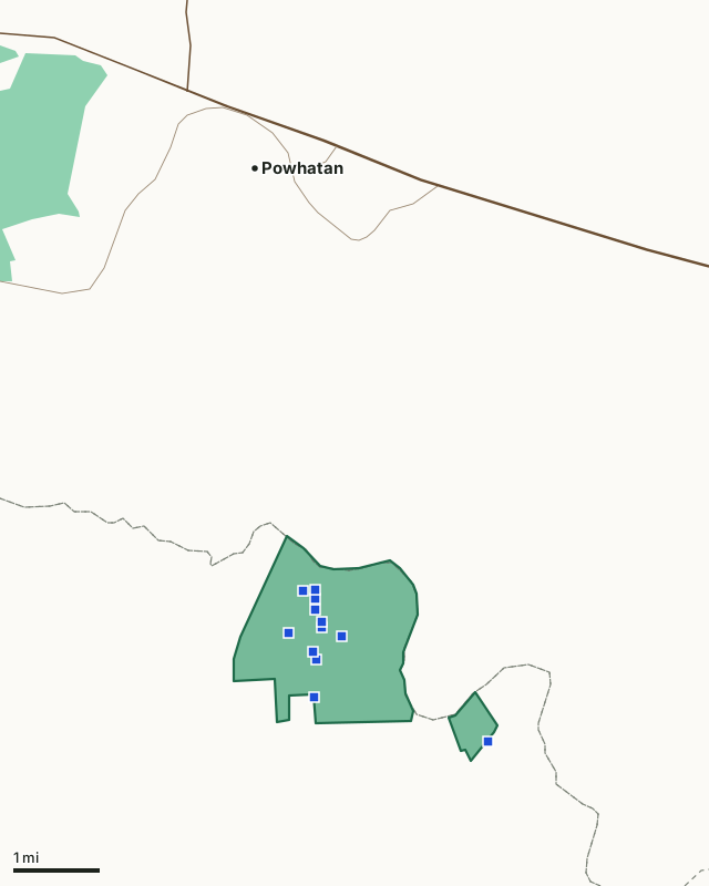
DWR land (WMAs)Amelia WMADWR parkingCounty lineHighway
| Size | 2,233 acres (DWR) |
|---|---|
| County | Amelia County |
| DWR region | Region 2 |
| Parking areas | 12 |
| Gates | 13 |
| Other facilities DWR maps | 10 kiosks, 2 shooting ranges, 1 fishing pier and 1 cemetery |
| Firearms deer season, 2026-27 | November 14 to January 2 |
| Nearest towns | Powhatan (4 mi), Amelia Court House (9 mi) and Woodlake (11 mi) |
Where do you park on Amelia WMA?
DWR maps 12 parking areas on Amelia WMA, listed north to south.
| Lot | Latitude, longitude | Kind (DWR) |
|---|---|---|
| 1 | 37.47083, -77.91545 | Parking |
| 2 | 37.47070, -77.91798 | Parking |
| 3 | 37.46929, -77.91541 | Parking |
| 4 | 37.46743, -77.91549 | Parking |
| 5 | 37.46535, -77.91417 | Parking |
| 6 | 37.46449, -77.91401 | Parking |
| 7 | 37.46357, -77.92116 | Parking |
| 8 | 37.46299, -77.90992 | Parking |
| 9 | 37.46037, -77.91596 | Parking |
| 10 | 37.45909, -77.91530 | Parking |
| 11 | 37.45278, -77.91603 | Parking |
| 12 | 37.44474, -77.87934 | Parking |
Source: DWR WMA facilities (parking, gates, boat ramps, ranges).
What roads and trails does Amelia WMA have?
DWR's road layer counts 2 miles of open road through or along it. DWR records 13 gates.
Other facilities on DWR's map: 10 kiosks, 2 shooting ranges, 1 fishing pier and 1 cemetery.
Sources: DWR WMA roads and trails; DWR WMA facilities (parking, gates, boat ramps, ranges). Miles measured by FilledTag from DWR's lines.
When can you hunt deer on Amelia WMA in 2026-27?
DWR's public lands table gives Amelia WMA its own firearms deer season: November 14 to January 2, with either-sex days November 21, November 28, and December 21-January 2. Early archery runs October 3 to November 13 statewide.
| County | WMA acres in it | Private land firearms season | Deer killed (whole county) | Bears (whole county) |
|---|---|---|---|---|
| Amelia County | 2,219 | November 14 to January 2 | 2,995 (2025) | 29 (2025) |
Seasons: DWR Deer Hunting Regulations and Seasons. Harvest: DWR Deer Kill Data; DWR Black Bear Harvest by County.
How do you get to Amelia WMA?
Highways within five miles: US 60 and VA 13. Nearest towns: Powhatan (4 miles), Amelia Court House (9 miles), Woodlake (11 miles) and Brandermill (12 miles).
DWR's page for the area: DWR, Amelia WMA.
Questions hunters ask
When is deer season on Amelia WMA?
DWR sets the 2026-27 firearms deer season on Amelia WMA at November 14 to January 2, with either-sex days November 21, November 28, and December 21-January 2. Early archery runs October 3 to November 13 statewide.
Where do you park on Amelia WMA?
DWR maps 12 parking areas on Amelia WMA. The coordinates of each are in the table on this page; the first is at 37.4636, -77.9212.
How big is Amelia WMA?
2,233 acres by DWR's records, in Amelia County.
How many deer are killed in Amelia County, where Amelia WMA is?
DWR counted 2,995 deer in Amelia County in 2025-26: 1,346 antlered bucks and 1,437 does. DWR does not publish a separate count for the WMA.
Get a Virginia hunt plan when they open
Hunt plans for Virginia are coming. Join the list and you'll hear first. The first 50 hunters in each new state get their plan free.
Until then, the free FilledTag app for iPhone has a map that works in every state, Virginia included.
Where these facts come from
- Boundary and acres: DWR Wildlife Management Areas. Parking, gates and facilities: DWR WMA facilities (parking, gates, boat ramps, ranges). Roads: DWR WMA roads and trails.
- Seasons: DWR Deer Hunting Regulations and Seasons. County harvest: DWR Deer Kill Data; DWR Black Bear Harvest by County.
- Public land around it: USGS Protected Areas Database of the United States (PAD-US 4.1). Highways and towns: U.S. Census Bureau TIGER/Line 2024 primary and secondary roads; U.S. Census Bureau 2024 Gazetteer, places.
FilledTag is not part of the Virginia Department of Wildlife Resources.