North Olympic Wildlife Area: hunting, units and access
The North Olympic Wildlife Area is 1,494 acres of land managed by WDFW in Region 6, in 12 units, inside GMUs 624, 621 and 603, measured from WDFW's boundary. Of the GMUs it touches, WDFW reports the most deer taken in GMU 624: 293 in 2025.
Data updated October 2026. Area facts: WDFW's page for the North Olympic Wildlife Area, read 2026-10-18, and WDFW's facility data. Harvest: WDFW reports to 2025.
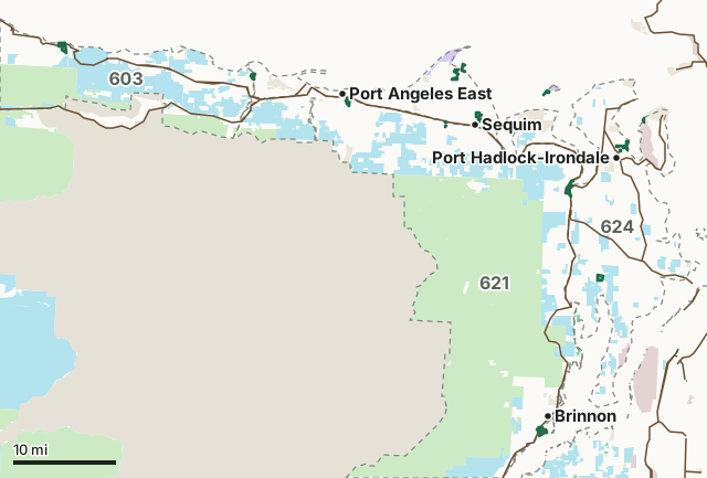
National forestDNR state trust landWDFW landNational wildlife refuge (refuge rules; not counted)National park or historic site (no hunting)Military land (restricted)Other public (parks, county, city, other agencies)North Olympic Wildlife AreaGMU lineLake or riverHighway
| Size | 1,494 acres (WDFW boundary, measured by FilledTag) |
|---|---|
| WDFW region | Region 6, Coastal Washington |
| GMUs | GMU 624, GMU 621, GMU 603 |
| Units | 12 |
| Roads and trails | 5 miles |
| Parking areas | 6 |
| Nearest towns | Sequim (next to it), Port Townsend (3 mi) and Port Angeles (4 mi) |
What is the North Olympic Wildlife Area like?
The North Olympic Wildlife Area is located in Clallam County and Jefferson County, and spans approximately 1,310 acres of managed lands throughout its units. It contains a mix of estuarine, riverine, wetland, oak-prairie, and mixed forest habitats that support a diversity of wildlife, from big and small game species to songbirds, as well as native and federally endangered fish populations.
In WDFW's words, from WDFW's North Olympic Wildlife Area page.
What units make up the North Olympic Wildlife Area?
WDFW manages the area as 12 units. The largest is Duckabush at 235 acres.
| Unit | Acres | GMUs | Parking areas | Campgrounds | Hunting blinds |
|---|---|---|---|---|---|
| Duckabush | 235 | 621, 624 | 1 | 0 | 0 |
| Twin Rivers | 212 | 603 | 0 | 0 | 0 |
| Discovery Bay | 196 | 621, 624 | 1 | 0 | 0 |
| Dungeness | 180 | 621, 624 | 2 | 0 | 0 |
| Tarboo | 158 | 624 | 1 | 0 | 0 |
| Morse Creek | 132 | 621 | 0 | 0 | 0 |
| Chimacum | 131 | 624 | 1 | 0 | 0 |
| Bell Creek | 90 | 624 | 0 | 0 | 0 |
| Elwha | 88 | 603, 624 | 0 | 0 | 0 |
| Zella Schultz | 39 | 624 | 0 | 0 | 0 |
| Marrowstone | 17 | 624 | 0 | 0 | 0 |
| South Sequim Bay | 15 | 624 | 0 | 0 | 0 |
Unit outlines and facilities: WDFW wildlife area and unit boundaries. Acres measured by FilledTag.
WDFW's notes for each unit
Duckabush: Some areas of this unit are affected by a Jefferson County NO SHOOTING AREA Jefferson County Regulations Chapter 8.50 (.150) No Shooting Area - Olympic Canal Tracts . WDFW
Twin Rivers: Hunting for deer, elk, bear, and waterfowl is allowed at this unit when applicable seasons are open. See the hunting regulations webpage for more information on when seasons are open for different species. WDFW
Dungeness: Due to popularity, waterfowl hunting at this site is subject to a number of rules. Hunting is restricted to Wednesday, Saturday, Sunday, and state and federal holidays. Hunting is restricted to WDFW designated points that are available on a first- come, first-serve basis. Occupancy of a hunt point is limited to a maximum of 4 persons. WDFW
Morse Creek: Per Clallam County Regulations Chapter 15.16 FIREARMS DISCHARGE RESTRICTIONS--RESTRICTED SHOOTING AREA 1 (North of 101). The area north of Highway 101, and bounded on the west by the Elwha River, on the south by Highway 101, on the east by the east county line, and on the north by the Strait of Juan de Fuca. Restricted Activity: It is unlawful to discharge, fire or shoot rifles, pistols or firearms of any type whatsoever, except for the use of shotguns, for hunting purposes with either shot or ball. WDFW
Chimacum: This unit is affected by a Jefferson County NO SHOOTING AREA [Jefferson County Regulations Chapter 8.50 (.180) No Shooting Area - Chimacum Creek] (https://www.codepublishing.com/WA/JeffersonCounty/?JeffersonCounty08/JeffersonCounty0850.html). WDFW
Bell Creek: Hunting is prohibited on this unit per City of Sequim ( 9.36.010 Weapons and dangerous exhibitions ) and Clallam County ( 15.16 Firearms Discharge Restrictions ) regulations. WDFW
Elwha: Per Clallam County Regulations Chapter 15.16 FIREARMS DISCHARGE RESTRICTIONS--RESTRICTED SHOOTING AREA 1 (North of 101). The area north of Highway 101, and bounded on the west by the Elwha River, on the south by Highway 101, on the east by the east county line, and on the north by the Strait of Juan de Fuca. Restricted Activity: It is unlawful to discharge, fire or shoot rifles, pistols or firearms of any type whatsoever, except for the use of shotguns, for hunting purposes with either shot or ball. WDFW
Marrowstone: Hunting is NOT allowed on the WDFW property that is adjacent to the Fort Flagler Historical State Park - there is a SAFETY ZONE in place at this location. WDFW
How many elk and deer are taken in the GMUs around the North Olympic Wildlife Area?
WDFW reports harvest by GMU, not by wildlife area. These are the whole GMUs the area lies in:
| GMU | Wildlife area acres in it | Elk taken, 2025 | Deer taken, 2025 | Bears taken, 2025 |
|---|---|---|---|---|
| GMU 624 Coyle | 666 | 0 | 293 | 6 |
| GMU 621 Olympic | 327 | 2 | 448 | 36 |
| GMU 603 Pysht | 263 | 20 | 130 | 5 |
Harvest: WDFW Game Harvest Reports (GMU, 2025). Wildlife area acres in each GMU measured by FilledTag from WDFW's boundaries.
How do you get to the North Olympic Wildlife Area?
Highways within 5 miles: US 101, SR 112, SR 20, SR 104 and SR 116. Nearest towns: Sequim (next to it), Port Townsend (3 miles), Port Angeles (4 miles) and Coupeville (9 miles).
Questions hunters ask
Do you need a pass to park at the North Olympic Wildlife Area?
Yes. Parking on WDFW land needs the Vehicle Access Pass that comes with most annual hunting and fishing licenses, or a Discover Pass, displayed where it can be seen from outside the vehicle (WDFW pamphlet, page 72).
Which GMUs is the North Olympic Wildlife Area in?
GMU 624 Coyle (666 acres), GMU 621 Olympic (327 acres) and GMU 603 Pysht (263 acres), by WDFW's boundaries. Seasons follow each GMU's rules.
Can you camp on the North Olympic Wildlife Area?
WDFW's facility data lists no developed campground on the North Olympic Wildlife Area. Camping on WDFW land follows WDFW's public conduct rules and any closures posted for the area; check WDFW's page before planning a camp.
Get a Washington hunt plan when they open
Hunt plans for Washington are coming. Join the list and you'll hear first. The first 50 hunters in each new state get their plan free.
Until then, the free FilledTag app for iPhone has a map that works in every state, Washington included.
Where these facts come from
- Area description, rules and access notes: WDFW, North Olympic Wildlife Area.
- Boundary, units and facilities: WDFW wildlife area and unit boundaries. Surrounding public land: WA DNR Major Public Lands (non-DNR) and WA DNR Managed Land Parcels, read 2026-10.
- GMU harvest: WDFW Game Harvest Reports. Parking passes: WDFW 2026 Big Game Hunting Seasons and Regulations, page 72.
FilledTag is not part of Washington Department of Fish and Wildlife. Numbers are copied from WDFW and the State of Washington, or measured from their maps; nothing on this page is estimated by FilledTag. WDFW's regulations are the final word on every rule.