Coastal Washington (WDFW Region 6): elk, deer and bear hunting by GMU
WDFW Region 6, run from Montesano, has 30 game management units and is 28.7% public land open to hunting. Adding up WDFW's GMU figures, hunters took 1,231 elk, 5,846 deer and 372 black bears (general season) in Region 6 in 2025.
Data updated October 2026. Harvest: WDFW reports to 2025. Land: WA DNR, 2026-10.
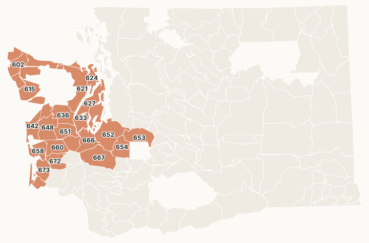
Region 6 is the Olympic Peninsula, the Willapa Hills and the south Puget Sound lowlands. Olympic National Park is closed to hunting; the Olympic National Forest and DNR trust land hold most of the region's public hunting ground.
Which GMUs are in Region 6?
All 30 GMUs in Region 6, with WDFW's 2025 harvest and the public land in each. The most elk were taken in GMU 652 (222), GMU 673 (172) and GMU 681 (134).
| GMU | Name | Square miles | Public land | Elk, 2025 | Deer, 2025 | Bears, 2025 |
|---|---|---|---|---|---|---|
| GMU 601 | Hoko | 131 | 8.9% | 0 | 39 | 6 |
| GMU 602 | Dickey | 285 | 33.3% | 14 | 114 | 11 |
| GMU 603 | Pysht | 234 | 55.2% | 20 | 130 | 5 |
| GMU 607 | Sol Duc | 204 | 76% | 36 | 52 | 2 |
| GMU 612 | Goodman | 119 | 38.1% | 18 | 34 | 8 |
| GMU 615 | Clearwater | 321 | 74% | 42 | 36 | 24 |
| GMU 618 | Matheny | 98 | 99.1% | 9 | 11 | 2 |
| GMU 621 | Olympic | 653 | 73.2% | 2 | 448 | 36 |
| GMU 624 | Coyle | 282 | 9.3% | 0 | 293 | 6 |
| GMU 627 | Kitsap | 533 | 5.4% | 0 | 282 | 25 |
| GMU 633 | Mason | 318 | 14.2% | 0 | 421 | 9 |
| GMU 636 | Skokomish | 377 | 56% | 0 | 195 | 8 |
| GMU 638 | Quinault Ridge | 147 | 85.9% | 15 | 19 | 3 |
| GMU 642 | Copalis | 277 | 9.1% | 5 | 39 | 25 |
| GMU 648 | Wynoochee | 431 | 3.9% | 13 | 346 | 24 |
| GMU 651 | Satsop | 296 | 2.8% | 11 | 291 | 3 |
| GMU 652 | Puyallup | 670 | 1.1% | 222 | 189 | 15 |
| GMU 653 | White River | 388 | 52.7% | 70 | 112 | 9 |
| GMU 654 | Mashel | 325 | 19.3% | 97 | 165 | 32 |
| GMU 655 | Anderson Island | 8 | 0% | 0 | 10 | |
| GMU 658 | North River | 256 | 5.1% | 38 | 190 | 9 |
| GMU 660 | Minot Peak | 302 | 15.8% | 63 | 289 | 29 |
| GMU 663 | Capitol Peak | 210 | 68.5% | 8 | 388 | 19 |
| GMU 666 | Deschutes | 354 | 1.8% | 35 | 276 | 8 |
| GMU 667 | Skookumchuck | 613 | 13.8% | 109 | 849 | 21 |
| GMU 672 | Fall River | 257 | 26% | 67 | 340 | 9 |
| GMU 673 | Williams Creek | 263 | 24.4% | 172 | 210 | 11 |
| GMU 681 | Bear River | 110 | 5.2% | 134 | 58 | 11 |
| GMU 684 | Long Beach | 50 | 3% | 22 | 20 | 2 |
| GMU 699 | Long Island | 8 | 0% | 9 | 0 | 0 |
Harvest: WDFW Game Harvest Reports (GMU, 2025); a linked number opens that GMU's page. Public land measured by FilledTag inside WDFW's GMU boundaries from WA DNR Major Public Lands (non-DNR) and WA DNR Managed Land Parcels, read 2026-10.
How many elk, deer and bears are taken in Region 6?
WDFW's GMU figures for Region 6 added together, for the last ten years.
| Year | Elk taken | General elk hunters | Deer taken | General deer hunters | Bears taken |
|---|---|---|---|---|---|
| 2025 | 1,231 | 10,516 | 5,846 | 20,685 | 372 |
| 2024 | 1,224 | 10,948 | 6,736 | 21,396 | 447 |
| 2023 | 1,229 | 10,601 | 5,265 | 20,226 | 407 |
| 2022 | 1,463 | 10,997 | 4,472 | 19,832 | 427 |
| 2021 | 1,494 | 11,955 | 5,182 | 22,246 | 332 |
| 2020 | 1,612 | 12,618 | 5,066 | 22,719 | 392 |
| 2019 | 1,584 | 11,159 | 5,422 | 21,237 | 510 |
| 2018 | 1,665 | 10,841 | 5,111 | 21,342 | 286 |
| 2017 | 1,413 | 10,234 | 4,421 | 21,721 | 284 |
| 2016 | 1,373 | 9,912 | 6,203 | 22,217 | 234 |
Source: WDFW Game Harvest Reports (GMU). Hunter counts are added across GMUs, so a hunter who hunted two GMUs is counted in each.
How much public land is in Region 6?
| Manager | Acres | Share of the region |
|---|---|---|
| National forest | 816,924 | 15% |
| DNR state trust land | 728,575 | 13.4% |
| Other public (parks, county, city, other agencies) | 104,217 | 1.9% |
| Military land (restricted) | 98,536 | 1.8% |
| WDFW land | 18,999 | 0.3% |
| National wildlife refuge (refuge rules; not counted) | 15,457 | 0.3% |
| National park or historic site (no hunting) | 1,208 | under 0.1% |
| BLM | 636 | under 0.1% |
WDFW wildlife areas in Region 6
WDFW manages 6 wildlife areas in Region 6, from Johns River (11,939 acres) down.
- Johns River: 11,939 acres
- South Puget Sound: 5,674 acres
- Scatter Creek: 5,221 acres
- North Olympic: 1,494 acres
- Olympic: 1,480 acres
- Chehalis: 1,234 acres
Questions hunters ask
Which GMUs in Region 6 have the most elk harvest?
By WDFW's 2025 report: GMU 652 Puyallup (222), GMU 673 Williams Creek (172) and GMU 681 Bear River (134).
Which GMUs in Region 6 have the most deer harvest?
By WDFW's 2025 report: GMU 667 Skookumchuck (849), GMU 621 Olympic (448) and GMU 633 Mason (421).
How much of Region 6 is public land?
28.7% of the region's GMUs, 1,565,134 of 5,454,413 acres, is public land open to hunting, most of it national forest, measured by FilledTag from WA DNR's maps.
Get a Washington hunt plan when they open
Hunt plans for Washington are coming. Join the list and you'll hear first. The first 50 hunters in each new state get their plan free.
Until then, the free FilledTag app for iPhone has a map that works in every state, Washington included.
Sources: WDFW Game Harvest Reports; WA DNR Major Public Lands (non-DNR) and WA DNR Managed Land Parcels, read 2026-10; WDFW wildlife area and unit boundaries.
FilledTag is not part of Washington Department of Fish and Wildlife. Numbers are copied from WDFW and the State of Washington, or measured from their maps; nothing on this page is estimated by FilledTag. WDFW's regulations are the final word on every rule.
Washington hunting Region 1 Region 2 Region 3 Region 4 Region 5