North Puget Sound (WDFW Region 4): elk, deer and bear hunting by GMU
WDFW Region 4, run from Mill Creek, has 25 game management units and is 48.1% public land open to hunting. Adding up WDFW's GMU figures, hunters took 225 elk, 1,981 deer and 215 black bears (general season) in Region 4 in 2025.
Data updated October 2026. Harvest: WDFW reports to 2025. Land: WA DNR, 2026-10.
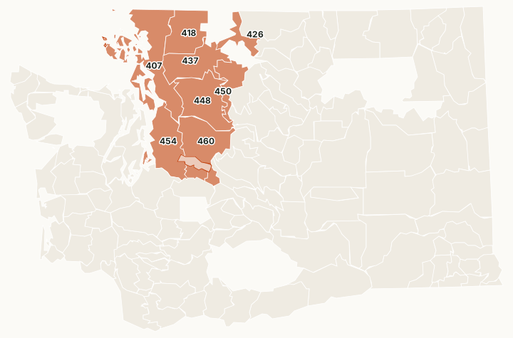
Region 4 runs from the Canadian border to King County, from the west slope of the North Cascades to the islands of Puget Sound. The Mount Baker-Snoqualmie National Forest holds most of its public land, and many lowland GMUs are close to towns and cities.
Which GMUs are in Region 4?
All 25 GMUs in Region 4, with WDFW's 2025 harvest and the public land in each. The most elk were taken in GMU 454 (106), GMU 460 (63) and GMU 437 (23).
| GMU | Name | Square miles | Public land | Elk, 2025 | Deer, 2025 | Bears, 2025 |
|---|---|---|---|---|---|---|
| GMU 407 | North Sound | 1,334 | 9.9% | 6 | 462 | 24 |
| GMU 410 | Islands | 34 | 1.5% | 0 | 60 | |
| GMU 411 | Orcas | 58 | 1.3% | 0 | 37 | |
| GMU 412 | Shaw | 8 | 0% | 0 | 10 | |
| GMU 413 | San Juan | 55 | 1.3% | 0 | 46 | |
| GMU 414 | Lopez | 29 | 5.5% | 0 | 62 | |
| GMU 415 | Blakely | 7 | 4.4% | 0 | 19 | |
| GMU 416 | Decatur | 3 | 0% | 0 | 7 | |
| GMU 417 | Cypress | 8 | 93.8% | 0 | 3 | |
| GMU 418 | Nooksack | 834 | 70.6% | 12 | 76 | 52 |
| GMU 419 | Guemes | 8 | 3.2% | 0 | 20 | |
| GMU 420 | Whidbey | 168 | 0.6% | 0 | 291 | |
| GMU 421 | Camano | 39 | 0.8% | 0 | 14 | |
| GMU 422 | Vashon - Maury | 36 | 0.2% | 0 | 122 | |
| GMU 423 | Henry | 2 | 6% | 0 | 0 | |
| GMU 424 | Stuart | 3 | 4% | 0 | 10 | |
| GMU 426 | Diablo | 322 | 93.5% | 0 | 30 | 6 |
| GMU 437 | Sauk | 882 | 60.8% | 23 | 201 | 46 |
| GMU 448 | Stillaguamish | 1,123 | 81.4% | 0 | 161 | 28 |
| GMU 450 | Cascade | 482 | 99.9% | 0 | 2 | 22 |
| GMU 454 | Issaquah | 970 | 4.6% | 106 | 164 | 12 |
| GMU 460 | Snoqualmie | 926 | 61.3% | 63 | 161 | 20 |
| GMU 466 | Stampede | 92 | 58.4% | 11 | 14 | 3 |
| GMU 485 | Green River | 136 | 53.8% | 4 | 9 | 2 |
| GMU 490 | Cedar River | 142 | 0% | 0 | 0 |
Harvest: WDFW Game Harvest Reports (GMU, 2025); a linked number opens that GMU's page. Public land measured by FilledTag inside WDFW's GMU boundaries from WA DNR Major Public Lands (non-DNR) and WA DNR Managed Land Parcels, read 2026-10.
How many elk, deer and bears are taken in Region 4?
WDFW's GMU figures for Region 4 added together, for the last ten years.
| Year | Elk taken | General elk hunters | Deer taken | General deer hunters | Bears taken |
|---|---|---|---|---|---|
| 2025 | 225 | 1,336 | 1,981 | 7,249 | 215 |
| 2024 | 309 | 1,600 | 2,156 | 7,757 | 343 |
| 2023 | 279 | 1,626 | 1,968 | 7,867 | 320 |
| 2022 | 319 | 1,544 | 1,940 | 8,012 | 340 |
| 2021 | 302 | 1,675 | 1,974 | 8,612 | 219 |
| 2020 | 268 | 1,827 | 2,591 | 10,003 | 325 |
| 2019 | 302 | 1,805 | 2,598 | 9,509 | 339 |
| 2018 | 273 | 1,724 | 2,645 | 9,492 | 226 |
| 2017 | 192 | 1,442 | 2,194 | 9,187 | 190 |
| 2016 | 233 | 1,578 | 2,740 | 9,207 | 217 |
Source: WDFW Game Harvest Reports (GMU). Hunter counts are added across GMUs, so a hunter who hunted two GMUs is counted in each.
How much public land is in Region 4?
| Manager | Acres | Share of the region |
|---|---|---|
| National forest | 1,726,974 | 35% |
| DNR state trust land | 523,712 | 10.6% |
| Other public (parks, county, city, other agencies) | 237,424 | 4.8% |
| National recreation area | 104,379 | 2.1% |
| WDFW land | 15,341 | 0.3% |
| Military land (restricted) | 12,450 | 0.3% |
| National park or historic site (no hunting) | 2,431 | under 0.1% |
| BLM | 1,635 | under 0.1% |
| National wildlife refuge (refuge rules; not counted) | 303 | under 0.1% |
WDFW wildlife areas in Region 4
WDFW manages 3 wildlife areas in Region 4, from Skagit (16,748 acres) down.
- Skagit: 16,748 acres
- Whatcom: 4,353 acres
- Snoqualmie: 2,851 acres
Questions hunters ask
Which GMUs in Region 4 have the most elk harvest?
By WDFW's 2025 report: GMU 454 Issaquah (106), GMU 460 Snoqualmie (63) and GMU 437 Sauk (23).
Which GMUs in Region 4 have the most deer harvest?
By WDFW's 2025 report: GMU 407 North Sound (462), GMU 420 Whidbey (291) and GMU 437 Sauk (201).
How much of Region 4 is public land?
48.1% of the region's GMUs, 2,372,041 of 4,929,269 acres, is public land open to hunting, most of it national forest, measured by FilledTag from WA DNR's maps.
Get a Washington hunt plan when they open
Hunt plans for Washington are coming. Join the list and you'll hear first. The first 50 hunters in each new state get their plan free.
Until then, the free FilledTag app for iPhone has a map that works in every state, Washington included.
Sources: WDFW Game Harvest Reports; WA DNR Major Public Lands (non-DNR) and WA DNR Managed Land Parcels, read 2026-10; WDFW wildlife area and unit boundaries.
FilledTag is not part of Washington Department of Fish and Wildlife. Numbers are copied from WDFW and the State of Washington, or measured from their maps; nothing on this page is estimated by FilledTag. WDFW's regulations are the final word on every rule.
Washington hunting Region 1 Region 2 Region 3 Region 5 Region 6