Eastern Washington (WDFW Region 1): elk, deer and bear hunting by GMU
WDFW Region 1, run from Spokane Valley, has 27 game management units and is 23.5% public land open to hunting. Adding up WDFW's GMU figures, hunters took 941 elk, 5,990 deer and 236 black bears (general season) in Region 1 in 2025.
Data updated October 2026. Harvest: WDFW reports to 2025. Land: WA DNR, 2026-10.
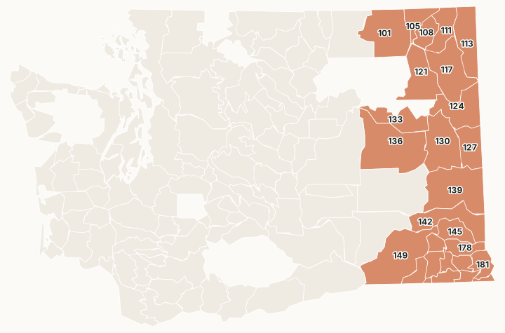
Region 1 runs from the Selkirk Mountains and the Kettle River Range on the Canadian border, through the Palouse farm country, to the Blue Mountains on the Oregon line. Most of its public ground is the Colville and Umatilla national forests, with DNR trust land second.
Which GMUs are in Region 1?
All 27 GMUs in Region 1, with WDFW's 2025 harvest and the public land in each. The most elk were taken in GMU 130 (138), GMU 121 (121) and GMU 124 (80).
| GMU | Name | Square miles | Public land | Elk, 2025 | Deer, 2025 | Bears, 2025 |
|---|---|---|---|---|---|---|
| GMU 101 | Sherman | 1,102 | 72.8% | 10 | 379 | 42 |
| GMU 105 | Kelly Hill | 296 | 47.5% | 18 | 176 | 9 |
| GMU 108 | Douglas | 288 | 24.3% | 15 | 196 | 13 |
| GMU 111 | Aladdin | 454 | 65.7% | 15 | 179 | 13 |
| GMU 113 | Selkirk | 735 | 76.3% | 47 | 199 | 27 |
| GMU 117 | 49 Degrees North | 954 | 34.6% | 68 | 358 | 20 |
| GMU 121 | Huckleberry | 795 | 19.7% | 121 | 698 | 25 |
| GMU 124 | Mount Spokane | 771 | 4.6% | 80 | 593 | 8 |
| GMU 127 | Mica Peak | 509 | 1.2% | 76 | 96 | 0 |
| GMU 130 | Cheney | 940 | 4% | 138 | 201 | 0 |
| GMU 133 | Roosevelt | 550 | 11.5% | 40 | 282 | 5 |
| GMU 136 | Harrington | 1,586 | 10.5% | 13 | 390 | 1 |
| GMU 139 | Steptoe | 1,327 | 2.9% | 59 | 319 | 0 |
| GMU 142 | Almota | 771 | 3.6% | 26 | 259 | 1 |
| GMU 145 | Mayview | 357 | 3.4% | 0 | 151 | 0 |
| GMU 149 | Prescott | 1,421 | 2.5% | 17 | 488 | 0 |
| GMU 154 | Blue Creek | 217 | 1.6% | 35 | 176 | 17 |
| GMU 157 | Mill Creek Watershed | 22 | 92.5% | 2 | 1 | |
| GMU 162 | Dayton | 210 | 25% | 18 | 200 | 20 |
| GMU 163 | Marengo | 150 | 4.8% | 6 | 97 | 0 |
| GMU 166 | Tucannon | 133 | 96.3% | 13 | 46 | 2 |
| GMU 169 | Wenaha | 161 | 100% | 7 | 9 | 8 |
| GMU 172 | Mountain View | 108 | 48.6% | 41 | 33 | 8 |
| GMU 175 | Lick Creek | 156 | 94.7% | 37 | 74 | 8 |
| GMU 178 | Peola | 277 | 4.8% | 12 | 189 | 0 |
| GMU 181 | Couse | 266 | 13.3% | 23 | 169 | 3 |
| GMU 186 | Grande Ronde | 53 | 48.9% | 4 | 32 | 6 |
Harvest: WDFW Game Harvest Reports (GMU, 2025); a linked number opens that GMU's page. Public land measured by FilledTag inside WDFW's GMU boundaries from WA DNR Major Public Lands (non-DNR) and WA DNR Managed Land Parcels, read 2026-10.
How many elk, deer and bears are taken in Region 1?
WDFW's GMU figures for Region 1 added together, for the last ten years.
| Year | Elk taken | General elk hunters | Deer taken | General deer hunters | Bears taken |
|---|---|---|---|---|---|
| 2025 | 941 | 8,793 | 5,990 | 28,374 | 236 |
| 2024 | 1,004 | 9,075 | 8,613 | 31,616 | 318 |
| 2023 | 907 | 8,720 | 8,161 | 33,273 | 354 |
| 2022 | 816 | 9,092 | 7,690 | 33,300 | 501 |
| 2021 | 885 | 9,173 | 8,394 | 36,196 | 381 |
| 2020 | 853 | 10,615 | 12,349 | 42,934 | 457 |
| 2019 | 846 | 9,471 | 10,819 | 39,516 | 389 |
| 2018 | 784 | 9,818 | 12,565 | 43,176 | 320 |
| 2017 | 858 | 9,842 | 12,802 | 44,103 | 346 |
| 2016 | 878 | 10,106 | 14,781 | 44,921 | 450 |
Source: WDFW Game Harvest Reports (GMU). Hunter counts are added across GMUs, so a hunter who hunted two GMUs is counted in each.
How much public land is in Region 1?
| Manager | Acres | Share of the region |
|---|---|---|
| National forest | 1,523,028 | 16.3% |
| DNR state trust land | 386,729 | 4.1% |
| BLM | 128,442 | 1.4% |
| Other public (parks, county, city, other agencies) | 124,267 | 1.3% |
| WDFW land | 99,634 | 1.1% |
| National wildlife refuge (refuge rules; not counted) | 72,599 | 0.8% |
| National recreation area | 56,819 | 0.6% |
| Military land (restricted) | 6,163 | 0.1% |
| Bureau of Reclamation | 592 | under 0.1% |
| National park or historic site (no hunting) | 135 | under 0.1% |
WDFW wildlife areas in Region 1
WDFW manages 7 wildlife areas in Region 1, from Asotin Creek (36,547 acres) down.
- Asotin Creek: 36,547 acres
- Chief Joseph: 25,296 acres
- Swanson Lakes: 21,476 acres
- W.T. Wooten: 16,952 acres
- Sherman Creek: 11,237 acres
- Revere: 2,415 acres
- LeClerc: 617 acres
Questions hunters ask
Which GMUs in Region 1 have the most elk harvest?
By WDFW's 2025 report: GMU 130 Cheney (138), GMU 121 Huckleberry (121) and GMU 124 Mount Spokane (80).
Which GMUs in Region 1 have the most deer harvest?
By WDFW's 2025 report: GMU 121 Huckleberry (698), GMU 124 Mount Spokane (593) and GMU 149 Prescott (488).
How much of Region 1 is public land?
23.5% of the region's GMUs, 2,195,244 of 9,349,767 acres, is public land open to hunting, most of it national forest, measured by FilledTag from WA DNR's maps.
Get a Washington hunt plan when they open
Hunt plans for Washington are coming. Join the list and you'll hear first. The first 50 hunters in each new state get their plan free.
Until then, the free FilledTag app for iPhone has a map that works in every state, Washington included.
Sources: WDFW Game Harvest Reports; WA DNR Major Public Lands (non-DNR) and WA DNR Managed Land Parcels, read 2026-10; WDFW wildlife area and unit boundaries.
FilledTag is not part of Washington Department of Fish and Wildlife. Numbers are copied from WDFW and the State of Washington, or measured from their maps; nothing on this page is estimated by FilledTag. WDFW's regulations are the final word on every rule.
Washington hunting Region 2 Region 3 Region 4 Region 5 Region 6