W.T. Wooten Wildlife Area: hunting, units and access
The W.T. Wooten Wildlife Area is 16,952 acres of land managed by WDFW in Region 1, in 3 units, inside GMUs 166, 163, 178, 149 and 162, measured from WDFW's boundary. The busiest elk unit it touches is GMU 166, where WDFW reports 13 elk taken in 2025.
Data updated October 2026. Area facts: WDFW's page for the W.T. Wooten Wildlife Area, read 2026-10-18, and WDFW's facility data. Harvest: WDFW reports to 2025.
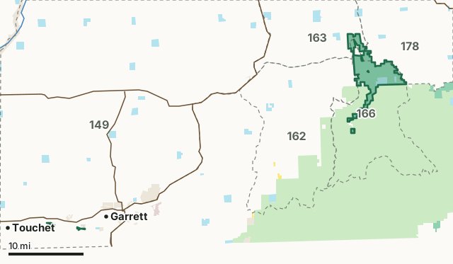
National forestBLMDNR state trust landWDFW landNational park or historic site (no hunting)Military land (restricted)Other public (parks, county, city, other agencies)W.T. Wooten Wildlife AreaGMU lineLake or riverHighway
| Size | 16,952 acres (WDFW boundary, measured by FilledTag) |
|---|---|
| WDFW region | Region 1, Eastern Washington |
| GMUs | GMU 166, GMU 163, GMU 178, GMU 149, GMU 162 |
| Units | 3 |
| Roads and trails | 36 miles |
| Parking areas | 27 |
| Campgrounds | 10 |
| Nearest towns | College Place (3 mi), Walla Walla (6 mi) and Pomeroy (7 mi) |
What is the W.T. Wooten Wildlife Area like?
Washington Department of Fish and Wildlife (WDFW) staff will conduct ongoing drone flights over eight locations of the W.T. Wooten Wildlife Area between April 20 and Dec. 31, 2026. Images and video obtained through these flights will be used to document impacts from a flood event in March of 2026 and create maps of eight areas where restoration projects will take place, as well as aid in designing restoration solutions. Flights will be conducted after each project is completed to compare before and after photos.
In WDFW's words, from WDFW's W.T. Wooten Wildlife Area page.
What units make up the W.T. Wooten Wildlife Area?
WDFW manages the area as 3 units. The largest is W.T. Wooten at 16,744 acres.
| Unit | Acres | GMUs | Parking areas | Campgrounds | Hunting blinds |
|---|---|---|---|---|---|
| W.T. Wooten | 16,744 | 162, 163, 166, 178 | 24 | 10 | 0 |
| McDonald Bridge | 121 | 149 | 1 | 0 | 0 |
| Swegle Road | 87 | 149 | 2 | 0 | 0 |
Unit outlines and facilities: WDFW wildlife area and unit boundaries. Acres measured by FilledTag.
WDFW's notes for each unit
W.T. Wooten: SAFETY ZONES are established around the Wooten Headquarters buildings, the Tucannon Fish Hatchery, and the Camp Wooten Environmental Learning Center. Weapons may not be discharged within these zones. WDFW
McDonald Bridge: Hunting is allowed by archery and shotgun only. WDFW
Swegle Road: Hunting is allowed by archery and shotgun only. WDFW
How many elk and deer are taken in the GMUs around the W.T. Wooten Wildlife Area?
WDFW reports harvest by GMU, not by wildlife area. These are the whole GMUs the area lies in:
| GMU | Wildlife area acres in it | Elk taken, 2025 | Deer taken, 2025 | Bears taken, 2025 |
|---|---|---|---|---|
| GMU 166 Tucannon | 13,868 | 13 | 46 | 2 |
| GMU 163 Marengo | 1,648 | 6 | 97 | 0 |
| GMU 178 Peola | 1,118 | 12 | 189 | 0 |
| GMU 149 Prescott | 209 | 17 | 488 | 0 |
| GMU 162 Dayton | 109 | 18 | 200 | 20 |
Harvest: WDFW Game Harvest Reports (GMU, 2025). Wildlife area acres in each GMU measured by FilledTag from WDFW's boundaries.
How do you get to the W.T. Wooten Wildlife Area?
Highways within 5 miles: US 12 and SR 125. Nearest towns: College Place (3 miles), Walla Walla (6 miles), Pomeroy (7 miles) and Dayton (13 miles).
Questions hunters ask
Do you need a pass to park at the W.T. Wooten Wildlife Area?
Yes. Parking on WDFW land needs the Vehicle Access Pass that comes with most annual hunting and fishing licenses, or a Discover Pass, displayed where it can be seen from outside the vehicle (WDFW pamphlet, page 72).
Which GMUs is the W.T. Wooten Wildlife Area in?
GMU 166 Tucannon (13,868 acres), GMU 163 Marengo (1,648 acres), GMU 178 Peola (1,118 acres), GMU 149 Prescott (209 acres) and GMU 162 Dayton (109 acres), by WDFW's boundaries. Seasons follow each GMU's rules.
Can you camp on the W.T. Wooten Wildlife Area?
WDFW's facility data lists 10 campgrounds on the W.T. Wooten Wildlife Area. Follow the posted rules and WDFW's public conduct rules.
Get a Washington hunt plan when they open
Hunt plans for Washington are coming. Join the list and you'll hear first. The first 50 hunters in each new state get their plan free.
Until then, the free FilledTag app for iPhone has a map that works in every state, Washington included.
Where these facts come from
- Area description, rules and access notes: WDFW, W.T. Wooten Wildlife Area.
- Boundary, units and facilities: WDFW wildlife area and unit boundaries. Surrounding public land: WA DNR Major Public Lands (non-DNR) and WA DNR Managed Land Parcels, read 2026-10.
- GMU harvest: WDFW Game Harvest Reports. Parking passes: WDFW 2026 Big Game Hunting Seasons and Regulations, page 72.
FilledTag is not part of Washington Department of Fish and Wildlife. Numbers are copied from WDFW and the State of Washington, or measured from their maps; nothing on this page is estimated by FilledTag. WDFW's regulations are the final word on every rule.
Washington hunting Region 1 GMU 166 elk GMU 163 elk GMU 178 elk GMU 149 elk GMU 162 elk