Sherman Creek Wildlife Area: hunting, units and access
The Sherman Creek Wildlife Area is 11,237 acres of land managed by WDFW in Region 1, in 3 units, inside GMUs 101, 117, 111 and 204, measured from WDFW's boundary. The busiest elk unit it touches is GMU 117, where WDFW reports 68 elk taken in 2025.
Data updated October 2026. Area facts: WDFW's page for the Sherman Creek Wildlife Area, read 2026-10-18, and WDFW's facility data. Harvest: WDFW reports to 2025.
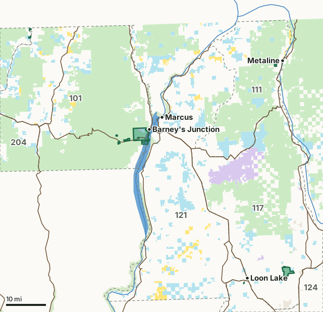
National forestBLMDNR state trust landWDFW landNational wildlife refuge (refuge rules; not counted)National recreation areaOther public (parks, county, city, other agencies)Sherman Creek Wildlife AreaGMU lineLake or riverHighway
| Size | 11,237 acres (WDFW boundary, measured by FilledTag) |
|---|---|
| WDFW region | Region 1, Eastern Washington |
| GMUs | GMU 101, GMU 117, GMU 111, GMU 204 |
| Units | 3 |
| Roads and trails | 69 miles |
| Parking areas | 8 |
| Boat ramps | 1 |
| Nearest towns | Metaline (2 mi), Metaline Falls (3 mi) and Kettle Falls (3 mi) |
What is the Sherman Creek Wildlife Area like?
Sherman Creek Wildlife Area consists of approximately 11,100 acres WDFW-owned land and approximately 560 U.S. Fish and Wildlife Service acres, all managed as one unit at the lower end of the Sherman Creek Watershed. The watershed begins at the Kettle Crest and flows 24 miles down to the Columbia River. The wildlife area is located along the west side of Lake Roosevelt, in the eastern foothills of the Kettle River Range in Ferry County, about 3 miles northwest of the town of Kettle Falls.
In WDFW's words, from WDFW's Sherman Creek Wildlife Area page.
What units make up the Sherman Creek Wildlife Area?
WDFW manages the area as 3 units. The largest is Sherman Creek at 8,259 acres.
| Unit | Acres | GMUs | Parking areas | Campgrounds | Hunting blinds |
|---|---|---|---|---|---|
| Sherman Creek | 8,259 | 101, 111 | 2 | 0 | 0 |
| Rustler's Gulch | 2,834 | 117, 124 | 4 | 0 | 0 |
| Kettle River | 144 | 204 | 2 | 0 | 0 |
Unit outlines and facilities: WDFW wildlife area and unit boundaries. Acres measured by FilledTag.
WDFW's notes for each unit
Sherman Creek: SAFETY ZONES have been established around the headquarters buildings, the Sherman Creek hatchery, and hay barn at the pheasant release site. No weapons may be discharged within these zones. WDFW
How many elk and deer are taken in the GMUs around the Sherman Creek Wildlife Area?
WDFW reports harvest by GMU, not by wildlife area. These are the whole GMUs the area lies in:
| GMU | Wildlife area acres in it | Elk taken, 2025 | Deer taken, 2025 | Bears taken, 2025 |
|---|---|---|---|---|
| GMU 101 Sherman | 8,100 | 10 | 379 | 42 |
| GMU 117 49 Degrees North | 2,817 | 68 | 358 | 20 |
| GMU 111 Aladdin | 155 | 15 | 179 | 13 |
| GMU 204 Okanogan East | 143 | 35 | 780 | 42 |
Harvest: WDFW Game Harvest Reports (GMU, 2025). Wildlife area acres in each GMU measured by FilledTag from WDFW's boundaries.
How do you get to the Sherman Creek Wildlife Area?
Highways within 5 miles: SR 20, US 395, US 2, SR 25 and SR 31. Nearest towns: Metaline (2 miles), Metaline Falls (3 miles), Kettle Falls (3 miles) and Marcus (5 miles).
Questions hunters ask
Do you need a pass to park at the Sherman Creek Wildlife Area?
Yes. Parking on WDFW land needs the Vehicle Access Pass that comes with most annual hunting and fishing licenses, or a Discover Pass, displayed where it can be seen from outside the vehicle (WDFW pamphlet, page 72).
Which GMUs is the Sherman Creek Wildlife Area in?
GMU 101 Sherman (8,100 acres), GMU 117 49 Degrees North (2,817 acres), GMU 111 Aladdin (155 acres) and GMU 204 Okanogan East (143 acres), by WDFW's boundaries. Seasons follow each GMU's rules.
Can you camp on the Sherman Creek Wildlife Area?
WDFW's facility data lists no developed campground on the Sherman Creek Wildlife Area. Camping on WDFW land follows WDFW's public conduct rules and any closures posted for the area; check WDFW's page before planning a camp.
Get a Washington hunt plan when they open
Hunt plans for Washington are coming. Join the list and you'll hear first. The first 50 hunters in each new state get their plan free.
Until then, the free FilledTag app for iPhone has a map that works in every state, Washington included.
Where these facts come from
- Area description, rules and access notes: WDFW, Sherman Creek Wildlife Area.
- Boundary, units and facilities: WDFW wildlife area and unit boundaries. Surrounding public land: WA DNR Major Public Lands (non-DNR) and WA DNR Managed Land Parcels, read 2026-10.
- GMU harvest: WDFW Game Harvest Reports. Parking passes: WDFW 2026 Big Game Hunting Seasons and Regulations, page 72.
FilledTag is not part of Washington Department of Fish and Wildlife. Numbers are copied from WDFW and the State of Washington, or measured from their maps; nothing on this page is estimated by FilledTag. WDFW's regulations are the final word on every rule.
Washington hunting Region 1 GMU 101 elk GMU 117 elk GMU 111 elk GMU 204 elk