Skagit Wildlife Area: hunting, units and access
The Skagit Wildlife Area is 16,748 acres of land managed by WDFW in Region 4, in 21 units, inside GMUs 407, 437, 410, 411 and 419, measured from WDFW's boundary. The busiest elk unit it touches is GMU 437, where WDFW reports 23 elk taken in 2025.
Data updated October 2026. Area facts: WDFW's page for the Skagit Wildlife Area, read 2026-10-18, and WDFW's facility data. Harvest: WDFW reports to 2025.
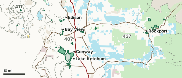
National forestBLMDNR state trust landWDFW landNational recreation areaNational park or historic site (no hunting)Military land (restricted)Other public (parks, county, city, other agencies)Skagit Wildlife AreaGMU lineLake or riverHighway
| Size | 16,748 acres (WDFW boundary, measured by FilledTag) |
|---|---|
| WDFW region | Region 4, North Puget Sound |
| GMUs | GMU 407, GMU 437, GMU 410, GMU 411, GMU 419 |
| Units | 21 |
| Roads and trails | 24 miles |
| Parking areas | 15 |
| Boat ramps | 2 |
| Nearest towns | La Conner (2 mi), Stanwood (2 mi) and Burlington (2 mi) |
What is the Skagit Wildlife Area like?
The Skagit Wildlife Area contains 18,138 acres of wildlife habitat composed primarily of intertidal estuary, managed agricultural lands, and native habitats. The area is divided into 21 separate management units, the majority of which are scattered throughout the west half of Skagit County, with some in Island, Snohomish, and San Juan counties. Many of the units are adjacent to Skagit, Padilla, and Port Susan bays, or near the glacial-fed Skagit River in the eastern portion of the county. Much of the intertidal ownership of the wildlife area is within the bounds of Skagit Bay's east shoreline, restricted mainly to second-class tidelands, intertidal marsh, and much of the upland area on the islands in the delta of the South Fork of the Skagit River. Also included are some intertidal lands along the shoreline of Camano Island in Skagit and Port Susan bays. Tidal action and the mixing of fresh and saltwater create a rich estuarine environment.
In WDFW's words, from WDFW's Skagit Wildlife Area page.
What units make up the Skagit Wildlife Area?
WDFW manages the area as 21 units. The largest is Skagit Bay Estuary at 10,555 acres.
| Unit | Acres | GMUs | Parking areas | Campgrounds | Hunting blinds |
|---|---|---|---|---|---|
| Skagit Bay Estuary | 10,555 | 407, 410 | 2 | 0 | 0 |
| Jackman Creek | 1,589 | 437 | 0 | 0 | 0 |
| Bald Eagle | 642 | 437 | 0 | 0 | 0 |
| Leque Island | 470 | 407 | 2 | 0 | 0 |
| Samish | 434 | 407 | 1 | 0 | 0 |
| Milltown Island | 402 | 407 | 0 | 0 | 0 |
| Debay's Slough | 390 | 407 | 2 | 0 | 0 |
| Skagit Headquarters | 374 | 407 | 2 | 0 | 0 |
| Fir Island Farm | 279 | 407 | 1 | 0 | 0 |
| South Padilla Bay | 277 | 407 | 2 | 0 | 0 |
| Island | 273 | 407 | 0 | 0 | 0 |
| Ross Island | 238 | 437 | 0 | 0 | 0 |
| Cottonwood Island | 232 | 407 | 1 | 0 | 0 |
| Killebrew Lake | 149 | 411 | 0 | 0 | 0 |
| Goat Island | 121 | 407 | 0 | 0 | 0 |
| Samish River | 107 | 407 | 1 | 0 | 0 |
| Lopez Island | 55 | 410 | 0 | 0 | 0 |
| Telegraph Slough | 52 | 407 | 1 | 0 | 0 |
| Guemes Island | 46 | 419 | 0 | 0 | 0 |
| Camano Island | 32 | 421 | 0 | 0 | 0 |
| Sinclair Island | 31 | 410 | 0 | 0 | 0 |
Unit outlines and facilities: WDFW wildlife area and unit boundaries. Acres measured by FilledTag.
WDFW's notes for each unit
Skagit Bay Estuary: It is unlawful to possess shot (either in shotshells or as loose shot for muzzleloading) other than nontoxic shot for any purpose on this unit (WAC 220-414-040). WDFW
Bald Eagle: Hunting can occur within the Bald Eagle Unit, but access is limited. WDFW
Leque Island: It is unlawful to possess shot (either in shotshells or as loose shot for muzzleloading) other than nontoxic shot for any purpose on this unit (WAC 220-414-040). WDFW
Samish: It is unlawful to have in possession more than 15 shotgun shells or to fire (shoot) more than 15 shells in one day on this unit (WAC 220-414-050). Hunters are not allowed to return to their vehicle for more shells after entering the field with their 15 shells. WDFW
Milltown Island: It is unlawful to possess shot (either in shotshells or as loose shot for muzzleloading) other than nontoxic shot for any purpose on this unit (WAC 220-414-040). WDFW
Debay's Slough: Small boats can be launched from DeBay Isle Road into the north portion of DeBay's Slough to provide waterfowl hunting access.| A map on the kiosk in the "Hunt Area" parking area shows the location of the Game Reserve.| Johnson/DeBay's Slough Game Reserve is established on this unit (WAC 220-411-120). Game Reserves are CLOSED AREAS where hunting and trapping for all wild animals and wild birds is prohibited (RCW 77.12.047). WDFW
Skagit Headquarters: It is unlawful to possess shot (either in shotshells or as loose shot for muzzleloading) other than nontoxic shot for any purpose on this unit (WAC 220-414-040). WDFW
South Padilla Bay: The unit supports three hunting blinds managed by WDFW's Private Lands Access Program. Due to safety concerns and to reduce disturbance to foraging waterfowl, hunting on the unit is limited to these three blinds. WDFW
How many elk and deer are taken in the GMUs around the Skagit Wildlife Area?
WDFW reports harvest by GMU, not by wildlife area. These are the whole GMUs the area lies in:
| GMU | Wildlife area acres in it | Elk taken, 2025 | Deer taken, 2025 | Bears taken, 2025 |
|---|---|---|---|---|
| GMU 407 North Sound | 5,454 | 6 | 462 | 24 |
| GMU 437 Sauk | 2,469 | 23 | 201 | 46 |
| GMU 410 Islands | 149 | 0 | 60 | 0 |
| GMU 411 Orcas | 149 | 0 | 37 | |
| GMU 419 Guemes | 45 | 0 | 20 | 0 |
Harvest: WDFW Game Harvest Reports (GMU, 2025). Wildlife area acres in each GMU measured by FilledTag from WDFW's boundaries.
How do you get to the Skagit Wildlife Area?
Highways within 5 miles: SR 20, I-5, SR 9, SR 11 and SR 532. Nearest towns: La Conner (2 miles), Stanwood (2 miles), Burlington (2 miles) and Sedro-Woolley (3 miles).
Questions hunters ask
Do you need a pass to park at the Skagit Wildlife Area?
Yes. Parking on WDFW land needs the Vehicle Access Pass that comes with most annual hunting and fishing licenses, or a Discover Pass, displayed where it can be seen from outside the vehicle (WDFW pamphlet, page 72).
Which GMUs is the Skagit Wildlife Area in?
GMU 407 North Sound (5,454 acres), GMU 437 Sauk (2,469 acres), GMU 410 Islands (149 acres), GMU 411 Orcas (149 acres) and GMU 419 Guemes (45 acres), by WDFW's boundaries. Seasons follow each GMU's rules.
Can you camp on the Skagit Wildlife Area?
WDFW's facility data lists no developed campground on the Skagit Wildlife Area. Camping on WDFW land follows WDFW's public conduct rules and any closures posted for the area; check WDFW's page before planning a camp.
Get a Washington hunt plan when they open
Hunt plans for Washington are coming. Join the list and you'll hear first. The first 50 hunters in each new state get their plan free.
Until then, the free FilledTag app for iPhone has a map that works in every state, Washington included.
Where these facts come from
- Area description, rules and access notes: WDFW, Skagit Wildlife Area.
- Boundary, units and facilities: WDFW wildlife area and unit boundaries. Surrounding public land: WA DNR Major Public Lands (non-DNR) and WA DNR Managed Land Parcels, read 2026-10.
- GMU harvest: WDFW Game Harvest Reports. Parking passes: WDFW 2026 Big Game Hunting Seasons and Regulations, page 72.
FilledTag is not part of Washington Department of Fish and Wildlife. Numbers are copied from WDFW and the State of Washington, or measured from their maps; nothing on this page is estimated by FilledTag. WDFW's regulations are the final word on every rule.