Mashel GMU 654 black bear hunting: harvest, season and land
WDFW's harvest report shows 32 black bears taken in GMU 654 Mashel in 2025. 303 bear hunters reported 2,883 days here, a success rate of 10.6% by WDFW's count. GMU 654 is 19.3% public land open to hunting, the largest share DNR state trust land (23,373 acres), measured from WA DNR's public land maps.
Data updated October 2026. Harvest: WDFW reports for 1997 to 2025. Seasons and permits: WDFW's 2026 pamphlet with its April 2026 corrections. Land: WA DNR, 2026-10.
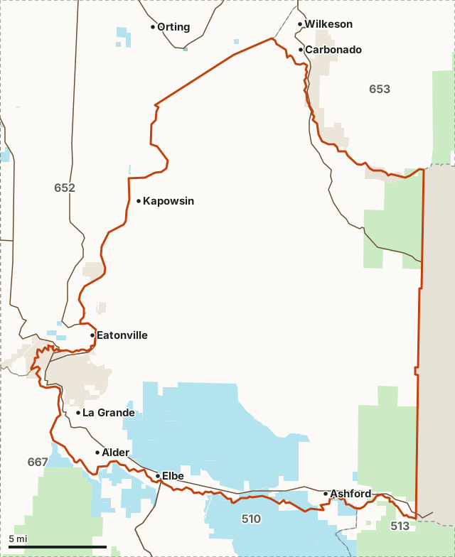
National forestDNR state trust landWDFW landNational park or historic site (no hunting)Other public (parks, county, city, other agencies)GMU 654Neighboring GMUsLake or riverHighway
| WDFW region | Region 6, Coastal Washington |
|---|---|
| Size | 208,184 acres (325 square miles) |
| Counties | Pierce |
| Public land open to hunting | 19.3% (40,078 acres) |
| Black bears taken, 2025 | 32 (38 in 2024) |
| Bear hunters, 2025 | 303 |
| 2026 fall season | August 1-November 15, bag limit 2 (Bear Management Unit 9, South Cascades West) |
| Towns in and near it | La Grande, Kapowsin, Alder, Eatonville, Carbonado and Wilkeson |
Also for GMU 654: elk hunting, deer hunting.
How many black bears are taken in GMU 654?
WDFW reports 32 black bears taken in GMU 654 in 2025, against 38 in 2024. The most in one year since 2000 was 49, in 2008. WDFW's figures average 26 a year for 2021 to 2025, against 20 a year for 2016 to 2020.
| Year | Bears taken, general season | Males | Females | Bear hunters | Hunter days | Success |
|---|---|---|---|---|---|---|
| 2025 | 32 | 23 | 9 | 303 | 2,883 | 10.6% |
| 2024 | 38 | 29 | 9 | 345 | 2,909 | 11% |
| 2023 | 21 | 17 | 4 | 368 | 2,876 | 5.8% |
| 2022 | 16 | 13 | 3 | 329 | 2,403 | 4.8% |
| 2021 | 21 | 7 | 14 | 370 | 3,135 | 5.6% |
| 2020 | 33 | 21 | 12 | 326 | 2,840 | 10.2% |
| 2019 | 30 | 20 | 10 | 325 | 2,512 | 9.2% |
| 2018 | 12 | 10 | 2 | 410 | 3,859 | 3% |
| 2017 | 6 | 6 | 0 | 397 | 2,942 | 2% |
| 2016 | 17 | 13 | 4 | 473 | 4,240 | 3.6% |
| 2015 | 20 | 17 | 3 | 491 | 4,048 | 4.1% |
| 2014 | 24 | 11 | 13 | 537 | 4,547 | 4.5% |
| 2013 | 14 | 10 | 4 | 517 | 4,370 | 2.7% |
| 2012 | 5 | 5 | 0 | 444 | 3,434 | 1.1% |
| 2011 | 33 | 0 | 0 | 558 | 4,418 | 5.9% |
| 2010 | 33 | 14 | 19 | 579 | 5,357 | 5.7% |
| 2009 | 22 | 13 | 9 | 582 | 5,932 | 4% |
| 2008 | 49 | 33 | 16 | 661 | 6,299 | 7% |
| 2007 | 12 | 8 | 4 | 461 | 3,926 | 2.6% |
| 2006 | 23 | 13 | 10 | 341 | 2,644 | 6.7% |
| 2005 | 28 | 19 | 9 | 424 | 3,547 | 6.6% |
| 2004 | 32 | 20 | 12 | 466 | 3,951 | 6.9% |
| 2003 | 31 | 20 | 11 | 451 | 3,658 | 6.9% |
| 2002 | 37 | 23 | 14 | 440 | 4,880 | 8.4% |
| 2001 | 35 | 20 | 15 | 415 | 3,857 | 8.4% |
| 2000 | 10 | 8 | 2 | 576 | 3,790 | 2% |
Source: WDFW Game Harvest Reports (black bear, GMU 654, 2000 to 2025), read through WDFW's Hunt Planner harvest table. Success is WDFW's own figure. The averages above are of WDFW's yearly figures.
When is bear season in GMU 654 in 2026?
GMU 654 is in Bear Management Unit 9, South Cascades West, which also takes in GMUs 466, 485, 503, 510, 513, 516, 560, 568, 572, 574 and 653. The 2026 fall general season there runs August 1-November 15, and the bag limit is 2. It is illegal to shoot a cub or a female with cubs, and every successful bear hunter must send WDFW the bear's first premolar tooth.
Source: WDFW 2026 Big Game Hunting Seasons and Regulations, page 68.
How much public land is in GMU 654?
19.3% of GMU 654 is public land open to hunting under its manager's rules: 40,078 of its 208,184 acres. The largest share is DNR state trust land, 23,373 acres or 11.2% of the unit. DNR trust land covers 23,373 acres; a Discover Pass is needed to hunt it.
| Manager | Acres | Share of GMU 654 |
|---|---|---|
| DNR state trust land | 23,373 | 11.2% |
| National forest | 16,683 | 8% |
| Other public (parks, county, city, other agencies) | 4,675 | 2.2% |
| National park or historic site (no hunting) | 529 | 0.3% |
| WDFW land | 22 | under 0.1% |
Measured by FilledTag inside WDFW's GMU boundary (WDFW game management units, in effect April 1, 2026 to March 31, 2027) from WA DNR Major Public Lands (non-DNR) and WA DNR Managed Land Parcels, read 2026-10. Tribal land is not counted as public. National wildlife refuges, military land and "other public" land (state parks, county, city and other agencies) are not counted as open to hunting: each sets its own rules.
How do you get to GMU 654?
Highways through the unit: SR 706 (about 14 miles inside it), SR 165 (about 12 miles inside it), SR 7 (about 11 miles inside it) and SR 161 (about 4 miles inside it). Towns inside: La Grande, Kapowsin, Alder, Ashford and Elbe. Nearby: Eatonville (on the line), Carbonado (on the line), Wilkeson (on the line) and South Prairie (3 miles).
Which GMUs border GMU 654?
GMU 654 touches 5 other GMUs. Their public land and WDFW's 2025 black bear numbers, for comparison:
| GMU | Name | Public land | Black bears taken, 2025 | Bear hunters, 2025 |
|---|---|---|---|---|
| GMU 510 | Stormking | 32.6% | 6 | 81 |
| GMU 513 | South Rainier | 93.2% | 4 | 156 |
| GMU 652 | Puyallup | 1.1% | 15 | 148 |
| GMU 653 | White River | 52.7% | 9 | 148 |
| GMU 667 | Skookumchuck | 13.8% | 21 | 462 |
Questions hunters ask
When is bear season in GMU 654 in 2026?
GMU 654 is in WDFW's Bear Management Unit 9 (South Cascades West), where the 2026 fall general season runs August 1-November 15 with a bag limit of 2, by the pamphlet's table on page 68. It is illegal to shoot a cub or a female with cubs.
How many bears are taken in GMU 654?
WDFW reports 32 black bears taken in GMU 654 in 2025 (23 males, 9 females). The most in one year since 2000 was 49, in 2008.
How much public land is in GMU 654?
19.3% of GMU 654, 40,078 of its 208,184 acres, is national forest, BLM, DNR trust, WDFW, Reclamation or national recreation area land; the largest share is DNR state trust land. Measured by FilledTag from WA DNR's public land maps.
What town is closest to GMU 654?
La Grande, Kapowsin and Alder are inside the unit. Just outside: Eatonville (on the line), Carbonado (on the line) and Wilkeson (on the line).
WDFW's boundary description of GMU 654
Beginning at the power transmission line at the Puyallup River Bridge on Orville Rd E; NE on the power line to the Carbon River; SE along the Carbon River to the west boundary of Mt. Rainier National Park; S on the Mt. Rainier National Park boundary to the Nisqually River; W down the Nisqually River to the mouth of the Mashel River; N up the Mashel River to the State Route (SR) 161 bridge (Eatonville-LaGrande Rd); N on SR 161 through Eatonville to Orville Rd E; N on Orville Rd E to the Puyallup River bridge and the point of beginning.
From WDFW 2026 Big Game Hunting Seasons and Regulations, Game Management Unit Descriptions.
Get a Washington hunt plan when they open
Hunt plans for Washington are coming. Join the list and you'll hear first. The first 50 hunters in each new state get their plan free.
Until then, the free FilledTag app for iPhone has a map that works in every state, Washington included.
Where these numbers come from
- Harvest, hunters, days and success: WDFW Game Harvest Reports.
- Seasons, special permits, applicants and points: WDFW 2026 Big Game Hunting Seasons and Regulations.
- Public land: WA DNR Major Public Lands (non-DNR) and WA DNR Managed Land Parcels, read 2026-10. GMU boundary: WDFW game management units, in effect April 1, 2026 to March 31, 2027.
- Highways and towns: U.S. Census Bureau TIGER/Line 2024 primary and secondary roads; U.S. Census Bureau 2024 Gazetteer, places.
FilledTag is not part of Washington Department of Fish and Wildlife. Numbers are copied from WDFW and the State of Washington, or measured from their maps; nothing on this page is estimated by FilledTag. WDFW's regulations are the final word on every rule.
Washington hunting Washington black bear by GMU Region 6 GMU 510 GMU 513 GMU 652 GMU 653 GMU 667