Scatter Creek Wildlife Area: hunting, units and access
The Scatter Creek Wildlife Area is 5,221 acres of land managed by WDFW in Region 6, in 8 units, inside GMUs 666, 667, 660 and 663, measured from WDFW's boundary. The busiest elk unit it touches is GMU 667, where WDFW reports 109 elk taken in 2025.
Data updated October 2026. Area facts: WDFW's page for the Scatter Creek Wildlife Area, read 2026-10-18, and WDFW's facility data. Harvest: WDFW reports to 2025.
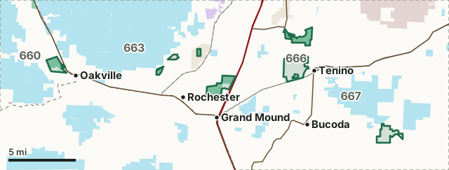
DNR state trust landWDFW landNational wildlife refuge (refuge rules; not counted)Military land (restricted)Other public (parks, county, city, other agencies)Scatter Creek Wildlife AreaGMU lineLake or riverHighway
| Size | 5,221 acres (WDFW boundary, measured by FilledTag) |
|---|---|
| WDFW region | Region 6, Coastal Washington |
| GMUs | GMU 666, GMU 667, GMU 660, GMU 663 |
| Units | 8 |
| Roads and trails | 37 miles |
| Parking areas | 11 |
| Boat ramps | 1 |
| Nearest towns | Tenino (next to it), Oakville (next to it) and Bucoda (3 mi) |
What is the Scatter Creek Wildlife Area like?
The Scatter Creek Wildlife Area is located in Thurston and Grays Harbor counties and is comprised of approximately 5,020 acres. Most of the units are located on tributaries that flow into the Chehalis River and contain portions of unique South Sound prairies. The wildlife area is located in the Puget Sound Trough lowlands with the Cascade Mountain Range to the east, the Willapa Hills to the southwest, and the Black Hills to the northwest. It lies on a glacial outwash plain, rimmed by low-lying hills formed by the last continental ice sheet 12,000 years ago. The units support many aquatic, forested, prairie, and wetland dependent wildlife species, some of which are federally threatened or endangered. Each unit provides vital habitat for many common species found throughout western Washington. In addition, units are managed either for recreation associated with fish and wildlife or for the protection of specific species and their habitats.
In WDFW's words, from WDFW's Scatter Creek Wildlife Area page.
What units make up the Scatter Creek Wildlife Area?
WDFW manages the area as 8 units. The largest is Violet Prairie at 1,482 acres.
| Unit | Acres | GMUs | Parking areas | Campgrounds | Hunting blinds |
|---|---|---|---|---|---|
| Violet Prairie | 1,482 | 666 | 0 | 0 | 0 |
| Scatter Creek | 1,080 | 666 | 3 | 0 | 0 |
| Skookumchuck | 883 | 667 | 4 | 0 | 0 |
| West Rocky Prairie | 810 | 666 | 1 | 0 | 0 |
| Davis Creek | 654 | 660 | 2 | 0 | 0 |
| Black River | 120 | 663 | 1 | 0 | 0 |
| Mima Creek | 113 | 663 | 0 | 0 | 0 |
| Glacial Heritage | 80 | 663 | 0 | 0 | 0 |
Unit outlines and facilities: WDFW wildlife area and unit boundaries. Acres measured by FilledTag.
WDFW's notes for each unit
Scatter Creek: On all WDFW designated pheasant release sites, it is unlawful to possess shot (either in shotshells or as loose shot for muzzleloading), other than nontoxic shot, when hunting for upland game birds (pheasant, quail, chukar, and gray partridge), mourning dove, and band-tailed pigeon ( WAC 220-414-040 ). WDFW
Skookumchuck: A SAFETY ZONE has been established on this unit. Weapons may not be discharged within this zone. WDFW
West Rocky Prairie: Portions of this area may be temporarily closed to hunting due to ongoing management activities. Information regarding these closures will be posted on the informational kiosk at the parking area. WDFW
Davis Creek: This unit is subject to firearm restrictions ( WAC 220-413-180 ) and non-toxic shot requirements ( WAC 220-414-040 ). WDFW
How many elk and deer are taken in the GMUs around the Scatter Creek Wildlife Area?
WDFW reports harvest by GMU, not by wildlife area. These are the whole GMUs the area lies in:
| GMU | Wildlife area acres in it | Elk taken, 2025 | Deer taken, 2025 | Bears taken, 2025 |
|---|---|---|---|---|
| GMU 666 Deschutes | 3,371 | 35 | 276 | 8 |
| GMU 667 Skookumchuck | 883 | 109 | 849 | 21 |
| GMU 660 Minot Peak | 654 | 63 | 289 | 29 |
| GMU 663 Capitol Peak | 312 | 8 | 388 | 19 |
Harvest: WDFW Game Harvest Reports (GMU, 2025). Wildlife area acres in each GMU measured by FilledTag from WDFW's boundaries.
How do you get to the Scatter Creek Wildlife Area?
Highways within 5 miles: I-5, US 12, SR 507 and SR 121. Nearest towns: Tenino (next to it), Oakville (next to it), Bucoda (3 miles) and Tumwater (6 miles).
Questions hunters ask
Do you need a pass to park at the Scatter Creek Wildlife Area?
Yes. Parking on WDFW land needs the Vehicle Access Pass that comes with most annual hunting and fishing licenses, or a Discover Pass, displayed where it can be seen from outside the vehicle (WDFW pamphlet, page 72).
Which GMUs is the Scatter Creek Wildlife Area in?
GMU 666 Deschutes (3,371 acres), GMU 667 Skookumchuck (883 acres), GMU 660 Minot Peak (654 acres) and GMU 663 Capitol Peak (312 acres), by WDFW's boundaries. Seasons follow each GMU's rules.
Can you camp on the Scatter Creek Wildlife Area?
WDFW's facility data lists no developed campground on the Scatter Creek Wildlife Area. Camping on WDFW land follows WDFW's public conduct rules and any closures posted for the area; check WDFW's page before planning a camp.
Get a Washington hunt plan when they open
Hunt plans for Washington are coming. Join the list and you'll hear first. The first 50 hunters in each new state get their plan free.
Until then, the free FilledTag app for iPhone has a map that works in every state, Washington included.
Where these facts come from
- Area description, rules and access notes: WDFW, Scatter Creek Wildlife Area.
- Boundary, units and facilities: WDFW wildlife area and unit boundaries. Surrounding public land: WA DNR Major Public Lands (non-DNR) and WA DNR Managed Land Parcels, read 2026-10.
- GMU harvest: WDFW Game Harvest Reports. Parking passes: WDFW 2026 Big Game Hunting Seasons and Regulations, page 72.
FilledTag is not part of Washington Department of Fish and Wildlife. Numbers are copied from WDFW and the State of Washington, or measured from their maps; nothing on this page is estimated by FilledTag. WDFW's regulations are the final word on every rule.
Washington hunting Region 6 GMU 666 elk GMU 667 elk GMU 660 elk GMU 663 elk