Ashland County, Wisconsin: public hunting land
Ashland County has 273,216 acres of public land open to the public, 40.5% of the county, the largest share national forest (182,202 acres), by USGS PAD-US 4.1 (fee land open to the public). The DNR's map shows 13 DNR properties here covering 14,873 acres, the largest Hay Creek-Hoffman Lake Wildlife Area (6,183 acres in the county). Deer here are counted by deer management unit: DMU 113 (1,776 deer in 2025), DMU 118 (475 deer in 2025), Bad River Reservation and DMU 106 (1,250 deer in 2025).
Data updated October 2026. Land: PAD-US 4.1. DNR properties and Voluntary Public Access land: the DNR's map layers, read 2026-10. Harvest: DNR Deer Metrics.
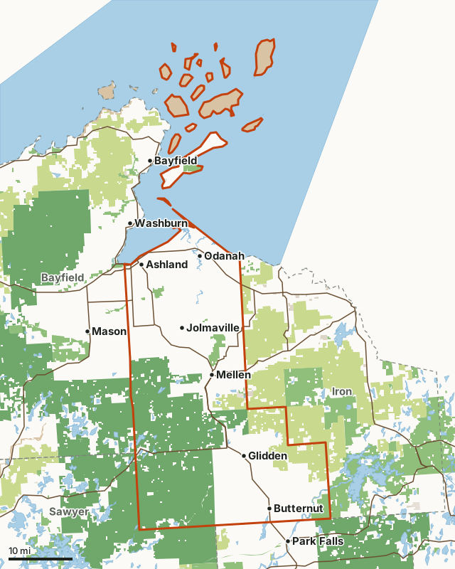
State wildlife areas, forests and other DNR landCounty forestNational forestNational wildlife refuges and waterfowl production areasNational park landOther county, city and regional landLand trusts and other open landAshland CountyNeighboring countiesLakeHighway
| Size | 674,542 acres (1,054 square miles) |
|---|---|
| Public land | 40.5% (273,216 acres) |
| Properties | 13 (14,873 acres) |
| Voluntary Public Access land | None mapped this year |
| Deer management units | DMU 113, DMU 118, Bad River Reservation, DMU 106, DMU 104, DMU 117, DMU 105 |
| Towns | Ashland, Mellen, Butternut, Jolmaville, Bayfield and Park Falls |
How much public hunting land is in Ashland County?
273,216 of the county's 674,542 acres are public land open to the public (40.5%). 237,211 acres of that are state wildlife, state forest or federal land, where hunting is the rule rather than the exception.
| Manager | Acres | Share of Ashland County |
|---|---|---|
| National forest | 182,202 | 27% |
| County forest | 39,620 | 5.9% |
| National park land | 34,656 | 5.1% |
| State wildlife areas, forests and other DNR land | 15,389 | 2.3% |
| Land trusts and other open land | 1,099 | 0.2% |
| Other county, city and regional land | 184 | under 0.1% |
| State parks | 66 | under 0.1% |
| All public land open to the public | 273,216 | 40.5% |
Measured by FilledTag inside the county line from USGS PAD-US 4.1 (fee land open to the public). DNR wildlife areas and state forests are open to hunting unless posted; county forests are open to hunting in most cases (check the county forest's rules); national forest land is open in season; refuges follow U.S. Fish and Wildlife Service rules; state parks allow hunting only in listed seasons and areas; national park land is closed to hunting.
The largest public areas in Ashland County by PAD-US, besides the properties: Chequamegon National Forest (182,216 acres), Ashland County Forest (39,571 acres), Apostle Islands National Lakeshore (34,656 acres) and Caroline Lake (1,069 acres).
Which DNR properties are in Ashland County?
13, largest first.
| Property | Acres in the county | DNR lists for hunting |
|---|---|---|
| Hay Creek-Hoffman Lake Wildlife Area | 6,183 | deer, wild turkey, ducks and geese, bear and small game |
| Copper Falls State Park | 3,536 | |
| Big Bay State Park | 2,522 | |
| White River Wildlife Area-Ashland | 1,276 | pheasants |
| Town of Morse State Habitat Area | 723 | |
| Turtle Flambeau Scenic Waters Area | 307 | |
| White River Fishery Area-Bayfield | 178 | |
| Copper Falls State North Country Trail Area | 61 | |
| Flambeau River State Forest | 38 | |
| Bosner Creek Conservation Easement Area | 21 | |
| Devil's Creek Fishery Area-Ashland | 13 | |
| Clam Lake Fishery Area | 8 | |
| Devil's Creek State Habitat Area | 7 |
How many deer are taken in Ashland County?
Since the DNR redrew its northern and central forest units in 2025, Ashland County is split among 7 deer management units that do not follow the county line, so there is no county total. The DNR has one year of numbers for the redrawn units so far. Each figure is for the whole unit.
| DMU | Share of the county | Deer harvested in the whole DMU | Year |
|---|---|---|---|
| DMU 113 | 41.7% | 1,776 | 2025 |
| DMU 118 | 20.5% | 475 | 2025 |
| Bad River Reservation | 17.5% | ||
| DMU 106 | 8.9% | 1,250 | 2025 |
| DMU 104 | 5.1% | ||
| DMU 117 | 4% | 895 | 2025 |
| DMU 105 | 2.2% | 57 | 2025 |
Harvest: Wisconsin DNR Deer Metrics (registered harvest by deer management unit). Share of the county measured by FilledTag from the DNR's deer management units and the Census county line.
How do you get around Ashland County?
Highways: WI 13 (about 55 miles in the county), WI 77 (about 34 miles in the county), US 2 (about 21 miles in the county), WI 112 (about 13 miles in the county) and WI 169 (about 10 miles in the county). Towns: Ashland, Mellen, Butternut, Jolmaville, Odanah, New Odanah, Glidden and Bayfront.
Questions hunters ask
How much public hunting land is in Ashland County, Wisconsin?
273,216 acres, 40.5% of the county, are public land open to the public by PAD-US 4.1; the largest share is national forest (182,202 acres).
What is the largest DNR property in Ashland County?
Hay Creek-Hoffman Lake Wildlife Area, with 6,183 acres inside the county.
Which deer management units cover Ashland County?
DMU 113 (41.7%), DMU 118 (20.5%), Bad River Reservation (17.5%), DMU 106 (8.9%), DMU 104 (5.1%), DMU 117 (4%) and DMU 105 (2.2%).
Does Ashland County have VPA land?
Not on the DNR's 2026 lease map.
Get a Wisconsin hunt plan when they open
Hunt plans for Wisconsin are coming. Join the list and you'll hear first. The first 50 hunters in each new state get their plan free.
Until then, the free FilledTag app for iPhone has a map that works in every state, Wisconsin included.
Where these numbers come from
- Public land: USGS PAD-US 4.1 (fee land open to the public). DNR properties: Wisconsin DNR managed lands open to hunting. Voluntary Public Access land: Wisconsin DNR Voluntary Public Access and Turkey Hunting Program lands.
- Deer harvest: Wisconsin DNR Deer Metrics (registered harvest by deer management unit).
- County line: U.S. Census Bureau 2024 cartographic county boundaries. Highways and towns: U.S. Census Bureau TIGER/Line 2024 primary and secondary roads.
FilledTag is not part of the Wisconsin Department of Natural Resources. Numbers are copied from the DNR and the federal sources above, or measured from their maps.
Wisconsin hunting Iron County Price County Sawyer County Bayfield County