White River Fishery Area-Bayfield: hunting and access
White River Fishery Area-Bayfield is 4,546 acres of land managed by the Wisconsin DNR in Bayfield and Ashland counties, next to Mason. Hunters registered 1,250 deer in DMU 106 in 2025.
Data updated October 2026. Area facts: the DNR's DNR property data, read 2026-10. Harvest: DNR Deer Metrics.
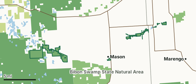
State wildlife areas, forests and other DNR landCounty forestNational forestWhite River Fishery Area-BayfieldCounty lineLakeHighway
| Size | 4,546 acres in 11 pieces |
|---|---|
| Counties | Bayfield County and Ashland County |
| Deer Management Unit | DMU 106, DMU 102 |
| Public access (DNR) | Open to Hiking, Fishing, Hunting and Trapping |
| DNR property page | White River Fishery Area (Bayfield and Ashland Counties) |
| Nearest towns | Mason (next to it), Grand View (5 mi) and Ashland (5 mi) |
What is White River Fishery Area-Bayfield like?
White River Fishery Area was established in 1961 to manage and protect this unique and scenic trout stream and watershed. This multiple use area is dedicated to trout fishing, hunting, canoeing, and other compatible outdoor recreational and educational opportunities. Numerous feeder streams, spring ponds, and outlet flows of several glacial lakes provide the high quality water for this outstanding trout stream. This premier trout water is primarily fished by wading. Portions of the river are canoeable and are fished that way. Habitat types include a riverine habitat transitioning from wooded headwaters, through the grassy swamp and steep clay banks, to a small impoundment. Three separate State Natural Areas are embedded within the fishery area boundary: Lake Two Pines, Sajdak Springs and White River Breaks.
The Friends of the White River serves as an informational resource for White River landowners and river users and as an advocate for the protection and preservation of the White River. It also serves as an advisory group to the DNR regarding the management of any state-acquired land in the newly expanded White River Fishery Area segment of the watershed. White River Fishery Area is located in Bayfield and Ashland Counties from south of Delta in Bayfield County to three miles south of Ashland in Ashland County. This premier trout water is primarily fished by wading. Portions of the river are canoeable and are fished that way.
In the DNR's words, from its page for the property.
What are the rules on White River Fishery Area-Bayfield?
The DNR's property map lists White River Fishery Area-Bayfield as "Open to Hiking, Fishing, Hunting and Trapping". Hunting follows Wisconsin's statewide seasons and the rules posted on the property.
Activities the DNR lists for White River Fishery Area-Bayfield: Hunting, Trapping, Hiking, Snowmobiling trail, Cross-country skiing - no groomed trails, Wildlife viewing and Fishing - brook & brown trout throughout, northern pike & suckers in limited areas.
How many deer are taken around White River Fishery Area-Bayfield?
White River Fishery Area-Bayfield lies in 2 deer management units. The DNR registered 1,250 deer in DMU 106 in 2025.
| DMU | White River Fishery Area-Bayfield acres in it | Deer, 2025 |
|---|---|---|
| DMU 106 | 2,875 | 1,250 |
| DMU 102 | 1,672 | 2,184 |
Harvest for the whole deer management unit, not the property alone: Wisconsin DNR Deer Metrics (registered harvest by deer management unit).
How do you get to White River Fishery Area-Bayfield?
Nearest towns: Mason (next to it), Grand View (5 miles), Ashland (5 miles) and Marengo (6 miles). Highways within 5 miles: US 63, WI 112, WI 13, US 2 and WI 118.
What other public land is near White River Fishery Area-Bayfield?
DNR properties within 10 miles:
- Bibon Swamp State Natural Area: 9,595 acres, 0.8 miles away
- White River Wildlife Area-Ashland: 1,276 acres, 1.2 miles away
- Inch Lake State Natural Area: 567 acres, 1.9 miles away
Public land within 3 miles of White River Fishery Area-Bayfield
Counting White River Fishery Area-Bayfield itself, 32,280 of the 119,718 acres within 3 miles of its boundary are public land open to the public (27%), by USGS PAD-US 4.1 (fee land open to the public).
| Manager | Acres within 3 miles |
|---|---|
| National forest | 21,316 |
| State wildlife areas, forests and other DNR land | 10,964 |
Questions hunters ask
Where is White River Fishery Area-Bayfield?
In Bayfield and Ashland counties, next to Mason. The DNR's property page has its maps and parking.
Is White River Fishery Area-Bayfield open to hunting?
Yes. The DNR's property map lists it as "Open to Hiking, Fishing, Hunting and Trapping". Posted refuges or closed areas, where there are any, are marked on site.
Which deer management unit is White River Fishery Area-Bayfield in?
DMU 106 (2,875 acres) and DMU 102 (1,672 acres).
How much public land is around White River Fishery Area-Bayfield?
32,280 acres within 3 miles of its boundary, White River Fishery Area-Bayfield included, by PAD-US 4.1. The closest other DNR property is Bibon Swamp State Natural Area (0.8 miles).
Get a Wisconsin hunt plan when they open
Hunt plans for Wisconsin are coming. Join the list and you'll hear first. The first 50 hunters in each new state get their plan free.
Until then, the free FilledTag app for iPhone has a map that works in every state, Wisconsin included.
Where these facts come from
- Area description, species, rules and directions: DNR, White River Fishery Area-Bayfield; Wisconsin DNR managed lands open to hunting.
- Boundary and acres: the DNR's map layer above. Surrounding public land: USGS PAD-US 4.1 (fee land open to the public).
- Deer harvest: Wisconsin DNR Deer Metrics (registered harvest by deer management unit).
FilledTag is not part of the Wisconsin Department of Natural Resources. Check the DNR's rules and posted signs before you go.