Inch Lake State Natural Area: hunting and access
Inch Lake State Natural Area is 567 acres of land managed by the Wisconsin DNR in Bayfield County, 5 miles from Iron River. Hunters registered 2,184 deer in DMU 102 in 2025.
Data updated October 2026. Area facts: the DNR's DNR property data, read 2026-10. Harvest: DNR Deer Metrics.
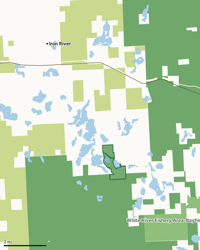
State wildlife areas, forests and other DNR landCounty forestNational forestInch Lake State Natural AreaCounty lineLakeHighway
| Size | 567 acres |
|---|---|
| County | Bayfield County |
| Deer Management Unit | DMU 102 |
| Public access (DNR) | Open to Hiking, Fishing, Hunting and Trapping |
| DNR property page | Inch Lake |
| Nearest towns | Iron River (5 mi), Drummond (10 mi) and Brule (11 mi) |
What is Inch Lake State Natural Area like?
Inch Lake SNA features two undeveloped lakes surrounded by wetlands and rolling upland forests. The property abuts the Chequamegon-Nicolet National Forest to the south. Inch Lake is a 31-acre undeveloped, soft-water seepage lake containing largemouth bass, yellow perch, and panfish. The 41-foot deep lake is classified as a "wild lake", an increasingly uncommon feature as development pressure intensifies in northern Wisconsin. No motors are allowed and only artificial lures may be used. These special regulations will provide important research opportunities related to fishing. Surrounding the southern portion of Inch Lake is a diverse northern mesic forest dominated by red pine, red oak, and aspen. Canopy associates include white spruce, white pine, and paper birch. The shrub layer contains abundant American hazelnut and sugar maple saplings.
The site also features scattered wetland depressions vegetated with wool grass, leather leaf, and sphagnum moss. Hildur Lake is a 66-acre hard-water drainage lake on the lower end of the Pike Lake chain. The lake and associated spring pond are the headwaters of the White River. The lake bottom is primarily gravel with a few scattered areas of sand and muck. Fish include northern pike, largemouth bass, muskie, yellow perch, bluegill, and crappie. Surrounding the lake is a narrow band of leatherleaf and alder with uplands comprised of mixed northern hardwoods. Rolling topography to the east supports a northern dry-mesic forest dominated by red pine with red oak and sugar maple. In addition, this area contains a diversity of other natural community types including a small wetland that supports nesting common loons. Bald eagles also occur here.
In the DNR's words, from its page for the property.
What are the rules on Inch Lake State Natural Area?
The DNR's property map lists Inch Lake State Natural Area as "Open to Hiking, Fishing, Hunting and Trapping". Hunting follows Wisconsin's statewide seasons and the rules posted on the property.
How many deer are taken around Inch Lake State Natural Area?
Inch Lake State Natural Area lies in DMU 102. The DNR registered 2,184 deer in DMU 102 in 2025.
| DMU | Inch Lake State Natural Area acres in it | Deer, 2025 |
|---|---|---|
| DMU 102 | 567 | 2,184 |
Harvest for the whole deer management unit, not the property alone: Wisconsin DNR Deer Metrics (registered harvest by deer management unit).
How do you get to Inch Lake State Natural Area?
Nearest towns: Iron River (5 miles), Drummond (10 miles), Brule (11 miles) and Mason (13 miles). Highways within 5 miles: US 2.
What other public land is near Inch Lake State Natural Area?
DNR properties within 10 miles:
- White River Fishery Area-Bayfield: 4,546 acres, 1.9 miles away
- Bibon Swamp State Natural Area: 9,595 acres, 8.1 miles away
Public land within 3 miles of Inch Lake State Natural Area
Counting Inch Lake State Natural Area itself, 15,160 of the 27,853 acres within 3 miles of its boundary are public land open to the public (54.4%), by USGS PAD-US 4.1 (fee land open to the public).
| Manager | Acres within 3 miles |
|---|---|
| National forest | 11,222 |
| County forest | 2,563 |
| State wildlife areas, forests and other DNR land | 1,375 |
Questions hunters ask
Where is Inch Lake State Natural Area?
In Bayfield County, 5 miles from Iron River. The DNR's property page has its maps and parking.
Is Inch Lake State Natural Area open to hunting?
Yes. The DNR's property map lists it as "Open to Hiking, Fishing, Hunting and Trapping". Posted refuges or closed areas, where there are any, are marked on site.
Which deer management unit is Inch Lake State Natural Area in?
DMU 102.
How much public land is around Inch Lake State Natural Area?
15,160 acres within 3 miles of its boundary, Inch Lake State Natural Area included, by PAD-US 4.1. The closest other DNR property is White River Fishery Area-Bayfield (1.9 miles).
Get a Wisconsin hunt plan when they open
Hunt plans for Wisconsin are coming. Join the list and you'll hear first. The first 50 hunters in each new state get their plan free.
Until then, the free FilledTag app for iPhone has a map that works in every state, Wisconsin included.
Where these facts come from
- Area description, species, rules and directions: DNR, Inch Lake State Natural Area; Wisconsin DNR managed lands open to hunting.
- Boundary and acres: the DNR's map layer above. Surrounding public land: USGS PAD-US 4.1 (fee land open to the public).
- Deer harvest: Wisconsin DNR Deer Metrics (registered harvest by deer management unit).
FilledTag is not part of the Wisconsin Department of Natural Resources. Check the DNR's rules and posted signs before you go.