Dodge County, Wisconsin: deer harvest and public hunting land
Dodge County is its own deer management unit, 907 square miles around Kekoskee. Hunters registered 5,477 deer here in 2025, 2,707 of them bucks, by the DNR's Deer Metrics. That is up 5% from 2024. 8.5% of Dodge County is public land open to the public, the largest share state wildlife areas, forests and other DNR land (24,644 acres), by USGS PAD-US 4.1 (fee land open to the public).
Data updated October 2026. Harvest: DNR Deer Metrics. Land: PAD-US 4.1, the DNR's managed lands and VPA layers.
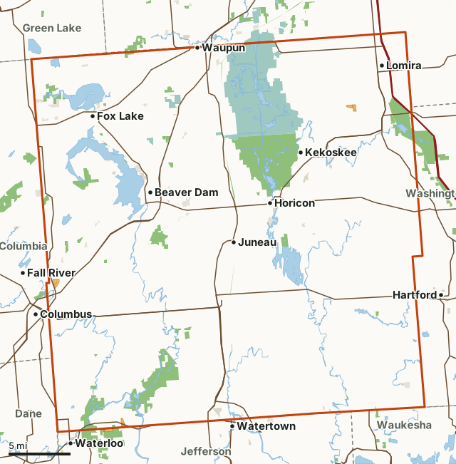
State wildlife areas, forests and other DNR landCounty forestNational wildlife refuges and waterfowl production areasOther county, city and regional landLand trusts and other open landVoluntary Public Access landDodge CountyNeighboring deer management unitsLakeHighway
| Counties | Dodge County |
|---|---|
| Size | 580,668 acres (907 square miles) |
| Deer registered, 2025 | 5,477 (2,707 bucks, 2,770 antlerless) |
| Yearly average, 2016 to 2025 | 4,531 deer |
| Public land | 8.5% (49,436 acres) |
| Properties | 8 (23,123 acres inside Dodge County) |
| Voluntary Public Access land | 3 sites, 360 acres |
| Towns in and near it | Kekoskee, Beaver Dam, Waupun, Watertown, Waterloo and Columbus |
How many deer are harvested in Dodge County?
The DNR registered 5,477 deer in Dodge County in 2025: 2,707 bucks and 2,770 antlerless deer, 51% of the harvest antlerless. Over the 10 years shown, the harvest averaged 4,531 deer a year; the most bucks were registered in 2024 (2,741).
| Year | Deer registered | Bucks | Antlerless | Antlerless share |
|---|---|---|---|---|
| 2025 | 5,477 | 2,707 | 2,770 | 51% |
| 2024 | 5,238 | 2,741 | 2,497 | 48% |
| 2023 | 4,552 | 2,377 | 2,175 | 48% |
| 2022 | 4,437 | 2,275 | 2,162 | 49% |
| 2021 | 4,123 | 2,039 | 2,084 | 51% |
| 2020 | 4,665 | 2,265 | 2,400 | 51% |
| 2019 | 3,951 | 1,879 | 2,072 | 52% |
| 2018 | 4,189 | 2,067 | 2,122 | 51% |
| 2017 | 4,171 | 2,013 | 2,158 | 52% |
| 2016 | 4,511 | 2,116 | 2,395 | 53% |
Source: Wisconsin DNR Deer Metrics, harvest history for Dodge County. Deer registered is the DNR's buck and antlerless harvest added together. The DNR's Deer Metrics shows every year back to 1960 for most counties.
How much public land is in Dodge County?
49,436 of Dodge County's 580,668 acres are public land open to the public (8.5%). The biggest share is state wildlife areas, forests and other DNR land: 24,644 acres.
| Manager | Acres | Share of Dodge County |
|---|---|---|
| State wildlife areas, forests and other DNR land | 24,644 | 4.2% |
| National wildlife refuges and waterfowl production areas | 21,701 | 3.7% |
| Land trusts and other open land | 1,964 | 0.3% |
| Other county, city and regional land | 1,023 | 0.2% |
| County forest | 79 | under 0.1% |
| State parks | 24 | under 0.1% |
| Other federal land | 1 | under 0.1% |
| All public land open to the public | 49,436 | 8.5% |
Measured by FilledTag inside the DNR's boundary from USGS PAD-US 4.1 (fee land open to the public). Hunting rules differ by manager: DNR wildlife areas and state forests are open to hunting unless posted; county forests are open to hunting in most cases (check the county forest's rules); national forest land is open in season; refuges follow U.S. Fish and Wildlife Service rules; state parks allow hunting only in listed seasons and areas; national park land is closed to hunting.
DNR properties in Dodge County
DNR properties in Dodge County, largest first, with the acres of each inside it:
- Horicon Marsh Wildlife Area: 11,181 acres
- Waterloo - Mud Lake Wildlife Area: 6,625 acres
- Theresa Wildlife Area: 2,528 acres
- Glacial Habitat Restoration Area: 1,302 acres
- Shaw Marsh Wildlife Area: 918 acres
- Sinnissippi Wildlife Area: 300 acres
- Wild Goose State Trail: 226 acres
- Habitat Area: 43 acres
Other large public areas here, by PAD-US: Horicon National Wildlife Refuge (20,922 acres), Dodge County Waterfowl Production Area (813 acres), Glacial Habitat Restoration (749 acres), Extensive Wl Habitat - Public Hunting Ground (420 acres), Brandt Quirk Park (169 acres) and Edgewater Park (153 acres).
Voluntary Public Access land in Dodge County
The DNR's 2026 lease map shows 3 properties in Dodge County, 360 acres of private land open to the public; one of them is spring-turkey-only Turkey Hunter Access land. No landowner permission is needed. DNR VPA program.
How do you get to Dodge County?
Highways through it: US 151 (about 53 miles inside), WI 26 (about 43 miles inside), WI 33 (about 38 miles inside), WI 16 (about 34 miles inside) and WI 60 (about 31 miles inside). Towns inside: Kekoskee, Beaver Dam, Waupun, Horicon, Mayville and Lomira. Nearby: Watertown (on the line), Waterloo (on the line), Columbus (on the line) and Fall River (2 miles).
Which deer management units border Dodge County?
Dodge County touches 7 other deer management units. Their latest DNR harvest and public land, for comparison:
| DMU | Deer harvested | Year | Public land | Voluntary Public Access land sites |
|---|---|---|---|---|
| Dane County | 4,438 | 2025 | 5.7% | 7 |
| Columbia County | 7,189 | 2025 | 5.5% | 4 |
| Waukesha County | 3,320 | 2025 | 7.9% | |
| Jefferson County | 3,843 | 2025 | 6.7% | 4 |
| Green Lake County | 4,589 | 2025 | 8.3% | 3 |
| Washington County | 3,731 | 2025 | 5.7% | 7 |
| Fond du Lac County | 4,642 | 2025 | 6.7% | 5 |
Questions hunters ask
How many deer were harvested in Dodge County in 2025?
5,477 deer were registered: 2,707 bucks and 2,770 antlerless deer (DNR Deer Metrics). In 2024: 5,238.
Is there public hunting land in Dodge County?
Yes. 49,436 acres, 8.5% of the unit, are public land open to the public by PAD-US 4.1, the largest share state wildlife areas, forests and other DNR land (24,644 acres). The DNR's map shows 8 DNR properties open to hunting here.
Does Dodge County have VPA land?
Yes. The DNR's 2026 lease map shows 3 properties, 360 acres.
Get a Wisconsin hunt plan when they open
Hunt plans for Wisconsin are coming. Join the list and you'll hear first. The first 50 hunters in each new state get their plan free.
Until then, the free FilledTag app for iPhone has a map that works in every state, Wisconsin included.
Where these numbers come from
- Deer harvest: Wisconsin DNR Deer Metrics (registered harvest by deer management unit).
- Public land: USGS PAD-US 4.1 (fee land open to the public). DNR properties: Wisconsin DNR managed lands open to hunting. Voluntary Public Access land: Wisconsin DNR Voluntary Public Access and Turkey Hunting Program lands.
- Boundaries: Wisconsin DNR deer management units. Highways and towns: U.S. Census Bureau TIGER/Line 2024 primary and secondary roads; U.S. Census Bureau 2024 Gazetteer, places.
FilledTag is not part of the Wisconsin Department of Natural Resources. Numbers are copied from the DNR and the federal sources above, or measured from their maps; nothing on this page is estimated by FilledTag.
Wisconsin hunting Dane County Columbia County Waukesha County Jefferson County Green Lake County Washington County Fond du Lac County