Bad Fish Creek Wildlife Area: hunting and access
Bad Fish Creek Wildlife Area is 1,155 acres of land managed by the Wisconsin DNR in Dane County, 3 miles from Stoughton. The DNR's page for it names deer, wild turkey, pheasants and ducks and geese among the game here. Hunters registered 4,438 deer in Dane County in 2025.
Data updated October 2026. Area facts: the DNR's DNR property data, read 2026-10. Harvest: DNR Deer Metrics.
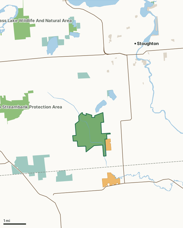
State wildlife areas, forests and other DNR landNational wildlife refuges and waterfowl production areasOther county, city and regional landVoluntary Public Access landBad Fish Creek Wildlife AreaCounty lineLakeHighway
| Size | 1,155 acres |
|---|---|
| County | Dane County |
| Deer Management Unit | Dane County |
| DNR lists for hunting | deer, wild turkey, pheasants and ducks and geese |
| Public access (DNR) | Open to Hiking, Fishing, Hunting and Trapping |
| DNR property page | Badfish Creek Wildlife Area |
| Nearest towns | Stoughton (3 mi), Brooklyn (5 mi) and Evansville (6 mi) |
What is Bad Fish Creek Wildlife Area like?
Badfish Creek Wildlife Area is located in Dane County, about 3 miles southwest of Stoughton and 3 miles southeast of Oregon. This property currently consists of 1,147 acres of state-owned land and 287 acres of leased land. This property can be reached from Madison by taking Highway 14 south, going east on Highway A and passing the Anthony Branch Fisheries and Wildlife Area, then taking your first right on Oak Ridge Road to continue to follow the boundary of the fisheries area. This road dead-ends at Old Stone Road. Take Old Stone Road until you get to Badfish Creek Wildlife Area.
The property is mainly wetland, although there are smaller areas of grassland and hardwood forest. The property is bisected by Badfish Creek, and several agricultural ditches can make access challenging. However, a pedestrian bridge across Badfish Creek allows access to either side of the creek. There is a Class II dog training area on the northeast side of the property. Highlights of the Badfish Creek Wildlife Area include several wetland scrapes that provide habitat to waterfowl and other wetland species, as well as a high-quality wet prairie in the southwest portion of the property that includes natural springs. With the help of the Friends of Badfish Creek Watershed, there are two maintained canoe/kayak launches on the property at the north and south ends. Although there are no maintained trails on the property, there are several access lanes that are used by hikers.
In the DNR's words, from its page for the property.
What can you hunt on Bad Fish Creek Wildlife Area?
The DNR's page for Bad Fish Creek Wildlife Area names deer, wild turkey, pheasants and ducks and geese. Each follows Wisconsin's statewide season and, for deer, the tags and rules of the deer management unit.
What are the rules on Bad Fish Creek Wildlife Area?
The DNR's property map lists Bad Fish Creek Wildlife Area as "Open to Hiking, Fishing, Hunting and Trapping". Hunting follows Wisconsin's statewide seasons and the rules posted on the property.
Activities the DNR lists for Bad Fish Creek Wildlife Area: Birding, Canoeing (landing at the northern parking lot), Class II dog training area*, Cross-country skiing (no designated trail), Fishing, Hiking (no designated trail), Hunting (especially noted for waterfowl, deer, turkey and stocked pheasant), Kayaking, Trapping and Wildlife viewing.
How many deer are taken around Bad Fish Creek Wildlife Area?
Bad Fish Creek Wildlife Area lies in Dane County. The DNR registered 4,438 deer in Dane County in 2025, against 4,403 in 2024.
| DMU | Bad Fish Creek Wildlife Area acres in it | Deer, 2025 | Deer, 2024 | Deer, 2023 |
|---|---|---|---|---|
| Dane County | 1,155 | 4,438 | 4,403 | 4,461 |
Harvest for the whole deer management unit, not the property alone: Wisconsin DNR Deer Metrics (registered harvest by deer management unit).
How do you get to Bad Fish Creek Wildlife Area?
Nearest towns: Stoughton (3 miles), Brooklyn (5 miles), Evansville (6 miles) and Oregon (6 miles). Highways within 5 miles: WI 138, US 14, US 51, WI 59 and WI 104. 2 VPA properties within 3 miles.
What other public land is near Bad Fish Creek Wildlife Area?
DNR properties within 10 miles:
- Anthony Branch Streambank Protection Area: 685 acres, 2.2 miles away
- Hook Lake/Grass Lake Wildlife And Natural Area: 875 acres, 4 miles away
- Allen Creek Streambank Protection Area: 220 acres, 5.6 miles away
- Evansville Wildlife Area: 839 acres, 5.6 miles away
Public land within 3 miles of Bad Fish Creek Wildlife Area
Counting Bad Fish Creek Wildlife Area itself, 2,657 of the 31,154 acres within 3 miles of its boundary are public land open to the public (8.5%), by USGS PAD-US 4.1 (fee land open to the public).
| Manager | Acres within 3 miles |
|---|---|
| State wildlife areas, forests and other DNR land | 1,589 |
| National wildlife refuges and waterfowl production areas | 1,008 |
| Other county, city and regional land | 60 |
Questions hunters ask
Where is Bad Fish Creek Wildlife Area?
In Dane County, 3 miles from Stoughton. The DNR's property page has its maps and parking.
Is Bad Fish Creek Wildlife Area open to hunting?
Yes. The DNR's property map lists it as "Open to Hiking, Fishing, Hunting and Trapping". Posted refuges or closed areas, where there are any, are marked on site.
Which deer management unit is Bad Fish Creek Wildlife Area in?
Dane County.
How much public land is around Bad Fish Creek Wildlife Area?
2,657 acres within 3 miles of its boundary, Bad Fish Creek Wildlife Area included, by PAD-US 4.1. The closest other DNR property is Anthony Branch Streambank Protection Area (2.2 miles).
Get a Wisconsin hunt plan when they open
Hunt plans for Wisconsin are coming. Join the list and you'll hear first. The first 50 hunters in each new state get their plan free.
Until then, the free FilledTag app for iPhone has a map that works in every state, Wisconsin included.
Where these facts come from
- Area description, species, rules and directions: DNR, Bad Fish Creek Wildlife Area; Wisconsin DNR managed lands open to hunting.
- Boundary and acres: the DNR's map layer above. Surrounding public land: USGS PAD-US 4.1 (fee land open to the public).
- Deer harvest: Wisconsin DNR Deer Metrics (registered harvest by deer management unit).
FilledTag is not part of the Wisconsin Department of Natural Resources. Check the DNR's rules and posted signs before you go.