Anthony Branch Streambank Protection Area: hunting and access
Anthony Branch Streambank Protection Area is 685 acres of land managed by the Wisconsin DNR in Dane County, 3 miles from Brooklyn. Hunters registered 4,438 deer in Dane County in 2025.
Data updated October 2026. Area facts: the DNR's DNR property data, read 2026-10. Harvest: DNR Deer Metrics.
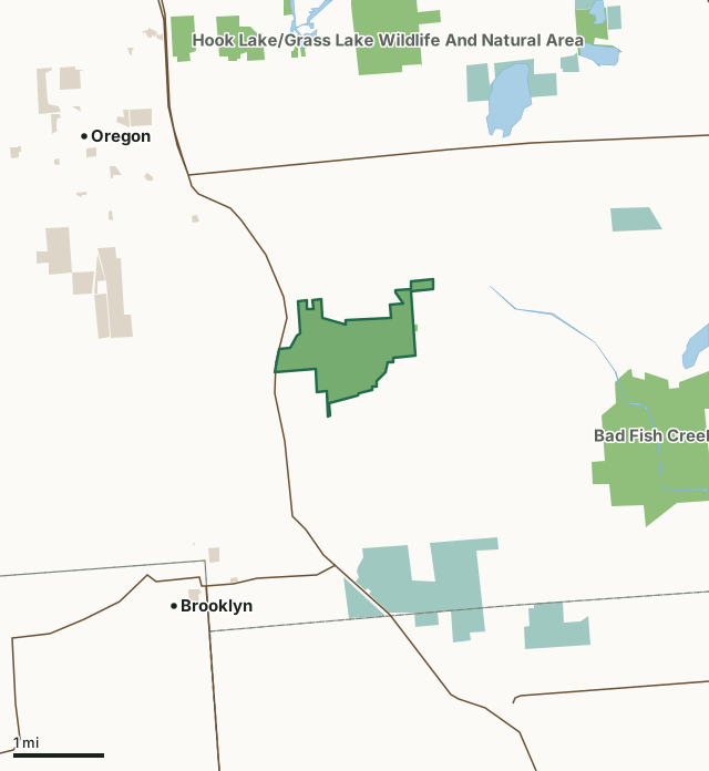
State wildlife areas, forests and other DNR landNational wildlife refuges and waterfowl production areasOther county, city and regional landAnthony Branch Streambank Protection AreaCounty lineLakeHighway
| Size | 685 acres |
|---|---|
| County | Dane County |
| Deer Management Unit | Dane County |
| Public access (DNR) | Open to Hiking, Fishing, Hunting and Trapping |
| DNR property page | Anthony Branch Fisheries and Wildlife Area |
| Nearest towns | Brooklyn (3 mi), Oregon (3 mi) and Stoughton (5 mi) |
What is Anthony Branch Streambank Protection Area like?
Anthony Branch Fisheries and Wildlife Area is over 1,000 acres in Southeast Dane County. This is an aesthetically pleasing property with gentle hills flowing into healthy wetlands and dotted with good woodland acres. Put all these ingredients together and you have a site that provides a good example of southern Wisconsin landscape at its best. The wetland is composed of wet-meadow, cattails, shrub-car, and sedge marsh with a high-quality creek meandering through it. The Anthony Branch is stocked with trout. The property is also laced with old agricultural ditches that one needs to become familiar with in order to learn where the fords are. There are a few old farm ponds on the north end of the property. They can become stagnant at times (i.e., keep your dog from jumping in them!).
The uplands are composed of prairie grass fields and cool-season fields. There are woodlands on the property that harbor oak and hickory. The southern side of the property is dominated by box elder. Anthony Branch Fisheries and Wildlife Area is located 3 miles southwest of Stoughton and 1.5 miles southeast of Oregon in Dane County. It is located in south central Wisconsin in the Badfish Creek Watershed. Wild Brown Trout inhabit the Anthony Branch and provide most of the fishing. Rainbow trout also live in this water. Due to its close proximity to Madison, this is an important recreation site for people who fish for trout.
In the DNR's words, from its page for the property.
What are the rules on Anthony Branch Streambank Protection Area?
The DNR's property map lists Anthony Branch Streambank Protection Area as "Open to Hiking, Fishing, Hunting and Trapping". Hunting follows Wisconsin's statewide seasons and the rules posted on the property.
Activities the DNR lists for Anthony Branch Streambank Protection Area: Hunting, Trapping, Hiking, Wildlife viewing, Fishing - Trout and Berry picking.
How many deer are taken around Anthony Branch Streambank Protection Area?
Anthony Branch Streambank Protection Area lies in Dane County. The DNR registered 4,438 deer in Dane County in 2025, against 4,403 in 2024.
| DMU | Anthony Branch Streambank Protection Area acres in it | Deer, 2025 | Deer, 2024 | Deer, 2023 |
|---|---|---|---|---|
| Dane County | 685 | 4,438 | 4,403 | 4,461 |
Harvest for the whole deer management unit, not the property alone: Wisconsin DNR Deer Metrics (registered harvest by deer management unit).
How do you get to Anthony Branch Streambank Protection Area?
Nearest towns: Brooklyn (3 miles), Oregon (3 miles), Stoughton (5 miles) and Evansville (7 miles). Highways within 5 miles: US 14, WI 138, US 51, WI 92 and WI 104.
What other public land is near Anthony Branch Streambank Protection Area?
DNR properties within 10 miles:
- Bad Fish Creek Wildlife Area: 1,155 acres, 2.2 miles away
- Hook Lake/Grass Lake Wildlife And Natural Area: 875 acres, 2.3 miles away
- Brooklyn Wildlife Area: 2,928 acres, 4.9 miles away
- Story Creek Streambank Protection Area: 497 acres, 4.9 miles away
Public land within 3 miles of Anthony Branch Streambank Protection Area
Counting Anthony Branch Streambank Protection Area itself, 3,187 of the 28,956 acres within 3 miles of its boundary are public land open to the public (11%), by USGS PAD-US 4.1 (fee land open to the public).
| Manager | Acres within 3 miles |
|---|---|
| State wildlife areas, forests and other DNR land | 1,754 |
| National wildlife refuges and waterfowl production areas | 1,034 |
| Other county, city and regional land | 399 |
Questions hunters ask
Where is Anthony Branch Streambank Protection Area?
In Dane County, 3 miles from Brooklyn. The DNR's property page has its maps and parking.
Is Anthony Branch Streambank Protection Area open to hunting?
Yes. The DNR's property map lists it as "Open to Hiking, Fishing, Hunting and Trapping". Posted refuges or closed areas, where there are any, are marked on site.
Which deer management unit is Anthony Branch Streambank Protection Area in?
Dane County.
How much public land is around Anthony Branch Streambank Protection Area?
3,187 acres within 3 miles of its boundary, Anthony Branch Streambank Protection Area included, by PAD-US 4.1. The closest other DNR property is Bad Fish Creek Wildlife Area (2.2 miles).
Get a Wisconsin hunt plan when they open
Hunt plans for Wisconsin are coming. Join the list and you'll hear first. The first 50 hunters in each new state get their plan free.
Until then, the free FilledTag app for iPhone has a map that works in every state, Wisconsin included.
Where these facts come from
- Area description, species, rules and directions: DNR, Anthony Branch Streambank Protection Area; Wisconsin DNR managed lands open to hunting.
- Boundary and acres: the DNR's map layer above. Surrounding public land: USGS PAD-US 4.1 (fee land open to the public).
- Deer harvest: Wisconsin DNR Deer Metrics (registered harvest by deer management unit).
FilledTag is not part of the Wisconsin Department of Natural Resources. Check the DNR's rules and posted signs before you go.