Bark Bay Slough State Natural Area: hunting and access
Bark Bay Slough State Natural Area is 646 acres of land managed by the Wisconsin DNR in Bayfield County, next to Herbster. Hunters registered 1,134 deer in DMU 103 in 2025.
Data updated October 2026. Area facts: the DNR's DNR property data, read 2026-10. Harvest: DNR Deer Metrics.
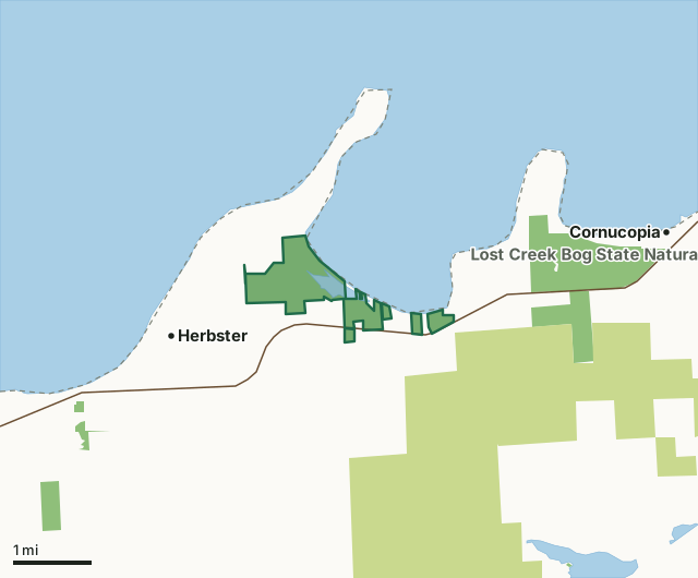
State wildlife areas, forests and other DNR landCounty forestBark Bay Slough State Natural AreaCounty lineLakeHighway
| Size | 646 acres in 6 pieces |
|---|---|
| County | Bayfield County |
| Deer Management Unit | DMU 103 |
| Public access (DNR) | Open to Hiking, Fishing, Hunting and Trapping |
| DNR property page | Bark Bay Slough |
| Nearest towns | Herbster (next to it), Cornucopia (3 mi) and Port Wing (9 mi) |
What is Bark Bay Slough State Natural Area like?
Bark Bay Slough consists of a coastal barrier spit, lagoon, springs, and wetlands occupying an embayment between two rocky headlands along Lake Superior. The wetlands are extensive and include two major types: coastal fen and coastal bog. The fen dominants are woolly sedge, twig rush, sweet gale, water horsetail and buckbean. The coastal bog is composed of a mat of Sphagnum mosses, ericaceous shrubs, sedges, carnivorous plants and scattered small tamarack. Both communities are floristically diverse, in excellent condition, and support many rare species. A forested interior sand spit parallel to the coastal barrier spit (or 'bay-mouth bar') breaks the wetlands into two major sections. The sandy, 2-mile-long barrier spit contains red pine and white pine with an understory of blueberry, bearberry, alder, sweet gale, and beach grasses.
A large lagoon occupies the center of the site and supports submergence and floating-leaved aquatic plants. Together, the wetlands and 28-acre lagoon form a bay-mouth bar lake. The shallow (8-foot maximum depth), hard water lake supports mostly panfish and northern pike. The Bark River, and a spring complex on the eastern end of the natural area supply water to the lake and wetlands. Birds present during the breeding season include bald eagle, sandhill crane, Brewer's blackbird, and American bittern. Substantial numbers of migrating shorebirds make use of the property. Bark Bay Slough is owned by the DNR and was designated a State Natural Area in 1977. If a developed trail is present, it will normally be noted on the SNA map and/or under the "Access" tab. NOTE : Per state regulations, hunting is allowed on the DNR-owned SNA lands.
In the DNR's words, from its page for the property.
What are the rules on Bark Bay Slough State Natural Area?
The DNR's property map lists Bark Bay Slough State Natural Area as "Open to Hiking, Fishing, Hunting and Trapping". Hunting follows Wisconsin's statewide seasons and the rules posted on the property.
How many deer are taken around Bark Bay Slough State Natural Area?
Bark Bay Slough State Natural Area lies in DMU 103. The DNR registered 1,134 deer in DMU 103 in 2025.
| DMU | Bark Bay Slough State Natural Area acres in it | Deer, 2025 |
|---|---|---|
| DMU 103 | 645 | 1,134 |
Harvest for the whole deer management unit, not the property alone: Wisconsin DNR Deer Metrics (registered harvest by deer management unit).
How do you get to Bark Bay Slough State Natural Area?
Nearest towns: Herbster (next to it), Cornucopia (3 miles), Port Wing (9 miles) and Bayfield (16 miles). Highways within 5 miles: WI 13.
What other public land is near Bark Bay Slough State Natural Area?
DNR properties within 10 miles:
- Lost Creek Bog State Natural Area: 847 acres, 1 mile away
- SSLSFA - Cranberry River Unit: 616 acres, 2.4 miles away
- Saxine Creek State Habitat Area: 237 acres, 6.3 miles away
- SSLSFA - Flag River Unit: 1,030 acres, 7.1 miles away
- Port Wing Boreal Forest State Natural Area: 227 acres, 7.6 miles away
Public land within 3 miles of Bark Bay Slough State Natural Area
Counting Bark Bay Slough State Natural Area itself, 6,103 of the 31,591 acres within 3 miles of its boundary are public land open to the public (19.3%), by USGS PAD-US 4.1 (fee land open to the public).
| Manager | Acres within 3 miles |
|---|---|
| County forest | 4,551 |
| State wildlife areas, forests and other DNR land | 1,552 |
Questions hunters ask
Where is Bark Bay Slough State Natural Area?
In Bayfield County, next to Herbster. The DNR's property page has its maps and parking.
Is Bark Bay Slough State Natural Area open to hunting?
Yes. The DNR's property map lists it as "Open to Hiking, Fishing, Hunting and Trapping". Posted refuges or closed areas, where there are any, are marked on site.
Which deer management unit is Bark Bay Slough State Natural Area in?
DMU 103.
How much public land is around Bark Bay Slough State Natural Area?
6,103 acres within 3 miles of its boundary, Bark Bay Slough State Natural Area included, by PAD-US 4.1. The closest other DNR property is Lost Creek Bog State Natural Area (1 mile).
Get a Wisconsin hunt plan when they open
Hunt plans for Wisconsin are coming. Join the list and you'll hear first. The first 50 hunters in each new state get their plan free.
Until then, the free FilledTag app for iPhone has a map that works in every state, Wisconsin included.
Where these facts come from
- Area description, species, rules and directions: DNR, Bark Bay Slough State Natural Area; Wisconsin DNR managed lands open to hunting.
- Boundary and acres: the DNR's map layer above. Surrounding public land: USGS PAD-US 4.1 (fee land open to the public).
- Deer harvest: Wisconsin DNR Deer Metrics (registered harvest by deer management unit).
FilledTag is not part of the Wisconsin Department of Natural Resources. Check the DNR's rules and posted signs before you go.