Lost Creek Bog State Natural Area: hunting and access
Lost Creek Bog State Natural Area is 847 acres of land managed by the Wisconsin DNR in Bayfield County, next to Cornucopia. Hunters registered 1,134 deer in DMU 103 in 2025.
Data updated October 2026. Area facts: the DNR's DNR property data, read 2026-10. Harvest: DNR Deer Metrics.
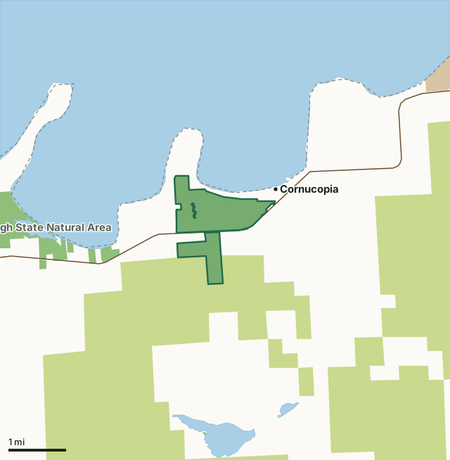
State wildlife areas, forests and other DNR landCounty forestNational park landLost Creek Bog State Natural AreaCounty lineLakeHighway
| Size | 847 acres in 2 pieces |
|---|---|
| County | Bayfield County |
| Deer Management Unit | DMU 103 |
| Public access (DNR) | Open to Hiking, Fishing, Hunting and Trapping |
| DNR property page | Lost Creek Bog |
| Nearest towns | Cornucopia (next to it), Herbster (5 mi) and Port Wing (12 mi) |
What is Lost Creek Bog State Natural Area like?
Lost Creek Bog features a Lake Superior estuarine system at the drowned mouths of three small creeks (Lost Creek 1, 2, and 3) where they empty into Siskiwit Bay. A coastal barrier sand spit forested with spruce and pine separates the wetlands from the lake. Shore fen, grading to open sedge bog, shrub swamp, and northern wet forest dominated by tamarack are the major communities in the natural area. The fen is well developed on the west and north sides of the lagoon, with a mat composed of woolly sedge, bogbean, sweet gale, and cotton grass. Boggy areas are dominated by Sphagnum mosses, sedges, leather-leaf and other ericaceous shrubs. Lost Creek 1 and 2 are flat, shallow, cold water streams with sandy bottoms that sustain a small brook trout population. Lost Creek 3 is a warm water drainage stream supporting minnows.
Bur-reed, water milfoil, yellow water-lily, common bladderwort, and pondweeds are among the submergent and floating-leaved species in the marsh. Several rare plants and animals have been recorded in the natural area. Uncommon nesting birds recorded here include yellow-bellied flycatcher and merlin. Migratory waterfowl and other water birds make extensive use of the site. Lost Creek Bog is owned by the DNR and was designated a State Natural Area in 1993. Bayfield County. T50N-R6W, Sections 4, 5. T51N-R6W, Sections 32, 33, 34. 853 acres. At the junction of State Highway 13 and County Highway C in Cornucopia, go west on Blueberry Lane about 1.3 miles to its end. Park at the undeveloped canoe/kayak launch for access to the northern portion of the bog via foot or water. The remainder of the wetland is best accessed by canoe/kayak.
In the DNR's words, from its page for the property.
What are the rules on Lost Creek Bog State Natural Area?
The DNR's property map lists Lost Creek Bog State Natural Area as "Open to Hiking, Fishing, Hunting and Trapping". Hunting follows Wisconsin's statewide seasons and the rules posted on the property.
How many deer are taken around Lost Creek Bog State Natural Area?
Lost Creek Bog State Natural Area lies in DMU 103. The DNR registered 1,134 deer in DMU 103 in 2025.
| DMU | Lost Creek Bog State Natural Area acres in it | Deer, 2025 |
|---|---|---|
| DMU 103 | 847 | 1,134 |
Harvest for the whole deer management unit, not the property alone: Wisconsin DNR Deer Metrics (registered harvest by deer management unit).
How do you get to Lost Creek Bog State Natural Area?
Nearest towns: Cornucopia (next to it), Herbster (5 miles), Port Wing (12 miles) and Bayfield (14 miles). Highways within 5 miles: WI 13.
What other public land is near Lost Creek Bog State Natural Area?
DNR properties within 10 miles:
- Bark Bay Slough State Natural Area: 646 acres, 1 mile away
- Saxine Creek State Habitat Area: 237 acres, 3.4 miles away
- SSLSFA - Cranberry River Unit: 616 acres, 5.6 miles away
- SSLSFA - Sioux River Unit: 2,299 acres, 9.2 miles away
- Nourse Sugarbush State Natural Area: 442 acres, 9.4 miles away
Public land within 3 miles of Lost Creek Bog State Natural Area
Counting Lost Creek Bog State Natural Area itself, 7,800 of the 30,601 acres within 3 miles of its boundary are public land open to the public (25.5%), by USGS PAD-US 4.1 (fee land open to the public).
| Manager | Acres within 3 miles |
|---|---|
| County forest | 6,509 |
| State wildlife areas, forests and other DNR land | 1,291 |
Questions hunters ask
Where is Lost Creek Bog State Natural Area?
In Bayfield County, next to Cornucopia. The DNR's property page has its maps and parking.
Is Lost Creek Bog State Natural Area open to hunting?
Yes. The DNR's property map lists it as "Open to Hiking, Fishing, Hunting and Trapping". Posted refuges or closed areas, where there are any, are marked on site.
Which deer management unit is Lost Creek Bog State Natural Area in?
DMU 103.
How much public land is around Lost Creek Bog State Natural Area?
7,800 acres within 3 miles of its boundary, Lost Creek Bog State Natural Area included, by PAD-US 4.1. The closest other DNR property is Bark Bay Slough State Natural Area (1 mile).
Get a Wisconsin hunt plan when they open
Hunt plans for Wisconsin are coming. Join the list and you'll hear first. The first 50 hunters in each new state get their plan free.
Until then, the free FilledTag app for iPhone has a map that works in every state, Wisconsin included.
Where these facts come from
- Area description, species, rules and directions: DNR, Lost Creek Bog State Natural Area; Wisconsin DNR managed lands open to hunting.
- Boundary and acres: the DNR's map layer above. Surrounding public land: USGS PAD-US 4.1 (fee land open to the public).
- Deer harvest: Wisconsin DNR Deer Metrics (registered harvest by deer management unit).
FilledTag is not part of the Wisconsin Department of Natural Resources. Check the DNR's rules and posted signs before you go.