Bean Brook Fishery Area: hunting and access
Bean Brook Fishery Area is 1,660 acres of land managed by the Wisconsin DNR in Washburn and Sawyer counties, 2 miles from Springbrook. Hunters registered 2,681 deer in DMU 109 in 2025.
Data updated October 2026. Area facts: the DNR's DNR property data, read 2026-10. Harvest: DNR Deer Metrics.
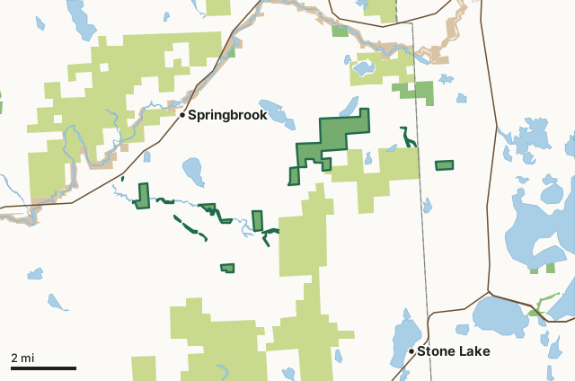
State wildlife areas, forests and other DNR landCounty forestNational park landLand trusts and other open landBean Brook Fishery AreaCounty lineLakeHighway
| Size | 1,660 acres in 20 pieces |
|---|---|
| Counties | Washburn County and Sawyer County |
| Deer Management Unit | DMU 109 |
| Public access (DNR) | Open to Hiking, Fishing, Hunting and Trapping |
| DNR property page | Bean Brook Fishery Area |
| Nearest towns | Springbrook (2 mi), Trego (5 mi) and Stone Lake (5 mi) |
What is Bean Brook Fishery Area like?
The Bean Brook Fishery Area complex consists of 1,728 acres among seven different parcels falling in two counties and four townships, mainly in east central Washburn County. The majority of the area is lowland alder, hardwood and conifer swamp with uplands a mix of aspen, mixed hardwood, pine, and upland brush. Bean and Little Bean Brook and Mackay Creek streams meander through the various pieces of the property. The largest, main body of the Bean Brook Fishery Area is located in Bass Lake Township, Washburn County, and north of County Hwy E. Parking lots for this area is located on Fire Lane Road, the end of Nobel Road and on County Hwy E.
Bean Brook Fishery Area is managed to protect the trout waters of the various streams and springs in the area and provide fishing, hunting, and other outdoor recreational pursuits.
In the DNR's words, from its page for the property.
What are the rules on Bean Brook Fishery Area?
The DNR's property map lists Bean Brook Fishery Area as "Open to Hiking, Fishing, Hunting and Trapping". Hunting follows Wisconsin's statewide seasons and the rules posted on the property.
Activities the DNR lists for Bean Brook Fishery Area: Hunting, Trapping, Hiking, Wildlife viewing, Fishing, Bird watching, Berry picking and Snowshoeing.
How many deer are taken around Bean Brook Fishery Area?
Bean Brook Fishery Area lies in DMU 109. The DNR registered 2,681 deer in DMU 109 in 2025.
| DMU | Bean Brook Fishery Area acres in it | Deer, 2025 |
|---|---|---|
| DMU 109 | 1,660 | 2,681 |
Harvest for the whole deer management unit, not the property alone: Wisconsin DNR Deer Metrics (registered harvest by deer management unit).
How do you get to Bean Brook Fishery Area?
Nearest towns: Springbrook (2 miles), Trego (5 miles), Stone Lake (5 miles) and Hayward (6 miles). Highways within 5 miles: US 63, WI 27, WI 70 and US 53.
What other public land is near Bean Brook Fishery Area?
DNR properties within 10 miles:
- Flat Creek Wildlife Area: 371 acres, 0.8 miles away
- Namekagon River State Habitat Area: 114 acres, 2.2 miles away
- Namekagon River - Trails End Rd SPA: 33 acres, 3.2 miles away
Public land within 3 miles of Bean Brook Fishery Area
Counting Bean Brook Fishery Area itself, 16,514 of the 74,011 acres within 3 miles of its boundary are public land open to the public (22.3%), by USGS PAD-US 4.1 (fee land open to the public).
| Manager | Acres within 3 miles |
|---|---|
| County forest | 12,860 |
| State wildlife areas, forests and other DNR land | 2,157 |
| National park land | 1,493 |
| Land trusts and other open land | 4 |
Questions hunters ask
Where is Bean Brook Fishery Area?
In Washburn and Sawyer counties, 2 miles from Springbrook. The DNR's property page has its maps and parking.
Is Bean Brook Fishery Area open to hunting?
Yes. The DNR's property map lists it as "Open to Hiking, Fishing, Hunting and Trapping". Posted refuges or closed areas, where there are any, are marked on site.
Which deer management unit is Bean Brook Fishery Area in?
DMU 109.
How much public land is around Bean Brook Fishery Area?
16,514 acres within 3 miles of its boundary, Bean Brook Fishery Area included, by PAD-US 4.1. The closest other DNR property is Flat Creek Wildlife Area (0.8 miles).
Get a Wisconsin hunt plan when they open
Hunt plans for Wisconsin are coming. Join the list and you'll hear first. The first 50 hunters in each new state get their plan free.
Until then, the free FilledTag app for iPhone has a map that works in every state, Wisconsin included.
Where these facts come from
- Area description, species, rules and directions: DNR, Bean Brook Fishery Area; Wisconsin DNR managed lands open to hunting.
- Boundary and acres: the DNR's map layer above. Surrounding public land: USGS PAD-US 4.1 (fee land open to the public).
- Deer harvest: Wisconsin DNR Deer Metrics (registered harvest by deer management unit).
FilledTag is not part of the Wisconsin Department of Natural Resources. Check the DNR's rules and posted signs before you go.