Flat Creek Wildlife Area: hunting and access
Flat Creek Wildlife Area is 371 acres of land managed by the Wisconsin DNR in Sawyer and Washburn counties, 4 miles from Hayward. Hunters registered 2,681 deer in DMU 109 in 2025.
Data updated October 2026. Area facts: the DNR's DNR property data, read 2026-10. Harvest: DNR Deer Metrics.
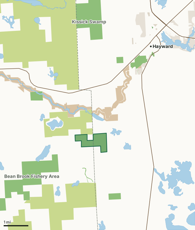
State wildlife areas, forests and other DNR landCounty forestNational forestNational park landOther county, city and regional landLand trusts and other open landFlat Creek Wildlife AreaCounty lineLakeHighway
| Size | 371 acres |
|---|---|
| Counties | Sawyer County and Washburn County |
| Deer Management Unit | DMU 109 |
| Public access (DNR) | Open to Hiking, Fishing, Hunting and Trapping |
| DNR property page | Flat Creek Wildlife Area |
| Nearest towns | Hayward (4 mi), Springbrook (6 mi) and Stone Lake (7 mi) |
What is Flat Creek Wildlife Area like?
Flat Creek Wildlife Area is a 373-acre property located on the center border of Washburn and Sawyer counties, in Bass Lake Township of both counties. The habitat is comprised of aspen, swamp conifer, tamarack, northern hardwoods, balsam fir, and Flat Creek itself, with numerous beaver ponds. The only access point for Flat Creek Wildlife Area is located at the end of Flat Creek Road, approximately 4 miles southwest of Hayward and 2.5 miles west of Highway 27. The remainder of the wildlife area can be explored via off-trail hiking, skiing and snowshoeing, providing a quiet, remote-feeling for visitors. The high-quality wetlands and mixed forest types allow great birdwatching, fishing, hunting and trapping opportunities. Notable species found at the wildlife area include white-tail deer, ruffed grouse, beaver and various waterfowl and warbler species.
The purchase of land for the Flat Creek Wildlife Area began in 1948, with the last purchase in 1953. The average price paid per acre at that time was $3 to $5. Management objectives are aimed at protecting and enhancing Flat Creek stream ecology and high-quality forest/forested wetland habitat types, including natural northern white cedar and hemlock communities for wildlife species. Management of the property also emphasizes habitat for waterfowl nesting, brood rearing and migratory stopovers, as well as protecting herptile nesting opportunities. Current management activity consists of numerous timber sales for wood fiber and wildlife habitat management. The Flat Creek Wildlife Area offers many recreational opportunities:.
In the DNR's words, from its page for the property.
What are the rules on Flat Creek Wildlife Area?
The DNR's property map lists Flat Creek Wildlife Area as "Open to Hiking, Fishing, Hunting and Trapping". Hunting follows Wisconsin's statewide seasons and the rules posted on the property.
Activities the DNR lists for Flat Creek Wildlife Area: Birding, Cross-country skiing (no designated trail), Hiking (no designated trail), Hunting, Snowshoeing, Trapping, Wild edibles/gathering and Wildlife viewing.
How many deer are taken around Flat Creek Wildlife Area?
Flat Creek Wildlife Area lies in DMU 109. The DNR registered 2,681 deer in DMU 109 in 2025.
| DMU | Flat Creek Wildlife Area acres in it | Deer, 2025 |
|---|---|---|
| DMU 109 | 371 | 2,681 |
Harvest for the whole deer management unit, not the property alone: Wisconsin DNR Deer Metrics (registered harvest by deer management unit).
How do you get to Flat Creek Wildlife Area?
Nearest towns: Hayward (4 miles), Springbrook (6 miles), Stone Lake (7 miles) and Little Round Lake (8 miles). Highways within 5 miles: US 63, WI 27 and WI 77.
What other public land is near Flat Creek Wildlife Area?
DNR properties within 10 miles:
- Bean Brook Fishery Area: 1,660 acres, 0.8 miles away
- Namekagon River State Habitat Area: 114 acres, 1.9 miles away
- Hayward Nursery: 135 acres, 2.7 miles away
- Stress Springs State Spring Ponds: 45 acres, 2.9 miles away
Public land within 3 miles of Flat Creek Wildlife Area
Counting Flat Creek Wildlife Area itself, 5,486 of the 25,627 acres within 3 miles of its boundary are public land open to the public (21.4%), by USGS PAD-US 4.1 (fee land open to the public).
| Manager | Acres within 3 miles |
|---|---|
| County forest | 3,017 |
| State wildlife areas, forests and other DNR land | 1,482 |
| National park land | 944 |
| Land trusts and other open land | 43 |
Questions hunters ask
Where is Flat Creek Wildlife Area?
In Sawyer and Washburn counties, 4 miles from Hayward. The DNR's property page has its maps and parking.
Is Flat Creek Wildlife Area open to hunting?
Yes. The DNR's property map lists it as "Open to Hiking, Fishing, Hunting and Trapping". Posted refuges or closed areas, where there are any, are marked on site.
Which deer management unit is Flat Creek Wildlife Area in?
DMU 109.
How much public land is around Flat Creek Wildlife Area?
5,486 acres within 3 miles of its boundary, Flat Creek Wildlife Area included, by PAD-US 4.1. The closest other DNR property is Bean Brook Fishery Area (0.8 miles).
Get a Wisconsin hunt plan when they open
Hunt plans for Wisconsin are coming. Join the list and you'll hear first. The first 50 hunters in each new state get their plan free.
Until then, the free FilledTag app for iPhone has a map that works in every state, Wisconsin included.
Where these facts come from
- Area description, species, rules and directions: DNR, Flat Creek Wildlife Area; Wisconsin DNR managed lands open to hunting.
- Boundary and acres: the DNR's map layer above. Surrounding public land: USGS PAD-US 4.1 (fee land open to the public).
- Deer harvest: Wisconsin DNR Deer Metrics (registered harvest by deer management unit).
FilledTag is not part of the Wisconsin Department of Natural Resources. Check the DNR's rules and posted signs before you go.