Beaver Brook Wildlife Area: hunting and access
Beaver Brook Wildlife Area is 1,920 acres of land managed by the Wisconsin DNR in Washburn County, next to Spooner. Hunters registered 1,418 deer in DMU Washburn in 2025.
Data updated October 2026. Area facts: the DNR's DNR property data, read 2026-10. Harvest: DNR Deer Metrics.
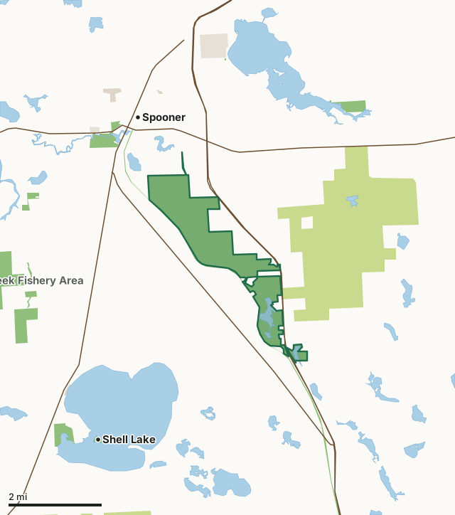
State wildlife areas, forests and other DNR landCounty forestState parksOther county, city and regional landLand trusts and other open landBeaver Brook Wildlife AreaCounty lineLakeHighway
| Size | 1,920 acres in 3 pieces |
|---|---|
| County | Washburn County |
| Deer Management Unit | DMU Washburn, DMU 109 |
| Public access (DNR) | Open to Hiking, Fishing, Hunting and Trapping |
| DNR property page | Beaver Brook Wildlife Area |
| Nearest towns | Spooner (next to it), Shell Lake (4 mi) and Trego (7 mi) |
What is Beaver Brook Wildlife Area like?
Beaver Brook is a 1,964-acre property located in southeast Washburn County. Because it is nestled between the cities of Shell Lake and Spooner, visitors can experience an outdoor adventure during the day and still make it back to town for dinner. This beautiful wildlife area is home to adventurous hunting, including deer, turkey, bear and ruffed grouse. It is also one of the state’s premier Class 1 brook and brown trout streams. Enjoy a day of birding in a variety of habitat types, a hike or ski on the rustic trails with a dog or simply sit by the water and listen to the frogs. The public artesian well along County B is a popular stop for many locals who come with their gallon jugs for water and then continue onto the property for berry picking. Beaver Brook is fed along its course by ten spring ponds and many banks seep and flow into the Yellow River.
Beaver Brook Wildlife Area is less than one mile southeast of Spooner. Access points include Wildlife Road off Highway 253, Randall Lake Road and Beaverbrook Ave off Highway 70 in Spooner, Cranberry Road, Wildcat Road off Highway 53, and from Highway B. Carry-in access to Harrison Lake is on Wildlife Road. Beaver Brook Wildlife Area was established in 1951 through the acquisition of 680 acres from Washburn County to protect and manage this great fishery and surrounding wildlife habitat. Ten more purchases occurred that have bringing the total acreage to 1,964 acres. The 2003 addition of 560 acres was added to the property by the DNR and Wisconsin Department of Transportation as part of a wetland mitigation project that restored the cranberry beds and associated flow. Trout are once again present in this stretch of the brook.
In the DNR's words, from its page for the property.
What are the rules on Beaver Brook Wildlife Area?
The DNR's property map lists Beaver Brook Wildlife Area as "Open to Hiking, Fishing, Hunting and Trapping". Hunting follows Wisconsin's statewide seasons and the rules posted on the property.
Activities the DNR lists for Beaver Brook Wildlife Area: Birding, Cross-country skiing ( designated trail; dogs permitted, and grooming begins after archery deer season ends), Fishing, Hiking (no designated trail; all dogs must be kept on a leash from April 15-July 31), Hunting, Snowshoeing, Trapping, Wild edibles/gathering and Wildlife viewing.
How many deer are taken around Beaver Brook Wildlife Area?
Beaver Brook Wildlife Area lies in 2 deer management units. The DNR registered 1,418 deer in DMU Washburn in 2025.
| DMU | Beaver Brook Wildlife Area acres in it | Deer, 2025 |
|---|---|---|
| DMU Washburn | 1,859 | 1,418 |
| DMU 109 | 60 | 2,681 |
Harvest for the whole deer management unit, not the property alone: Wisconsin DNR Deer Metrics (registered harvest by deer management unit).
How do you get to Beaver Brook Wildlife Area?
Nearest towns: Spooner (next to it), Shell Lake (4 miles), Trego (7 miles) and Haugen (10 miles). Highways within 5 miles: US 53, US 63, WI 70 and WI 253.
What other public land is near Beaver Brook Wildlife Area?
DNR properties within 10 miles:
- Wild Rivers State Trail: 1,158 acres, next to it
- Gov. Tommy G. Thompson Hatchery: 118 acres, 0.9 miles away
- Tozer State Spring Ponds: 32 acres, 2.3 miles away
- Sawyer Creek Fishery Area: 727 acres, 2.9 miles away
- Spooner Lake State Habitat Area: 84 acres, 3.1 miles away
Public land within 3 miles of Beaver Brook Wildlife Area
Counting Beaver Brook Wildlife Area itself, 6,051 of the 43,835 acres within 3 miles of its boundary are public land open to the public (13.8%), by USGS PAD-US 4.1 (fee land open to the public).
| Manager | Acres within 3 miles |
|---|---|
| County forest | 3,598 |
| State wildlife areas, forests and other DNR land | 2,201 |
| Land trusts and other open land | 204 |
| Other county, city and regional land | 44 |
| State parks | 4 |
Questions hunters ask
Where is Beaver Brook Wildlife Area?
In Washburn County, next to Spooner. The DNR's property page has its maps and parking.
Is Beaver Brook Wildlife Area open to hunting?
Yes. The DNR's property map lists it as "Open to Hiking, Fishing, Hunting and Trapping". Posted refuges or closed areas, where there are any, are marked on site.
Which deer management unit is Beaver Brook Wildlife Area in?
DMU Washburn (1,859 acres) and DMU 109 (60 acres).
How much public land is around Beaver Brook Wildlife Area?
6,051 acres within 3 miles of its boundary, Beaver Brook Wildlife Area included, by PAD-US 4.1. The closest other DNR property is Wild Rivers State Trail (next to it).
Get a Wisconsin hunt plan when they open
Hunt plans for Wisconsin are coming. Join the list and you'll hear first. The first 50 hunters in each new state get their plan free.
Until then, the free FilledTag app for iPhone has a map that works in every state, Wisconsin included.
Where these facts come from
- Area description, species, rules and directions: DNR, Beaver Brook Wildlife Area; Wisconsin DNR managed lands open to hunting.
- Boundary and acres: the DNR's map layer above. Surrounding public land: USGS PAD-US 4.1 (fee land open to the public).
- Deer harvest: Wisconsin DNR Deer Metrics (registered harvest by deer management unit).
FilledTag is not part of the Wisconsin Department of Natural Resources. Check the DNR's rules and posted signs before you go.