Sawyer Creek Fishery Area: hunting and access
Sawyer Creek Fishery Area is 727 acres of land managed by the Wisconsin DNR in Washburn County, 3 miles from Shell Lake. Hunters registered 1,418 deer in DMU Washburn in 2025.
Data updated October 2026. Area facts: the DNR's DNR property data, read 2026-10. Harvest: DNR Deer Metrics.
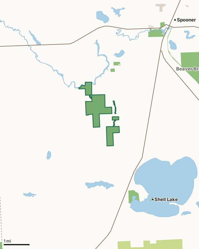
State wildlife areas, forests and other DNR landCounty forestState parksOther county, city and regional landLand trusts and other open landSawyer Creek Fishery AreaCounty lineLakeHighway
| Size | 727 acres in 6 pieces |
|---|---|
| County | Washburn County |
| Deer Management Unit | DMU Washburn |
| Public access (DNR) | Open to Hiking, Fishing, Hunting and Trapping |
| DNR property page | Sawyer Creek Fishery Area |
| Nearest towns | Shell Lake (3 mi), Spooner (4 mi) and Barronett (9 mi) |
What is Sawyer Creek Fishery Area like?
Sawyer Creek is clear water, spring-fed trout stream located in the southwest part of Washburn County. It originates from springs at the base of steep hills just north of the Village of Shell Lake and flows in a northerly direction (6.2 miles) to its confluence with the Yellow River. As the stream flows from its headwaters, it passes through tag alder-tamarack-black spruce swamps, sedge marshes and well-drained wooded upland. The stream picks up additional water from numerous spring seeps. Sawyer Creek Springs (a 1.1-acre natural spring pond), Beaver Lodge Pond (a 4.0-acre natural spring pond which empties into Sawyer Creek by way of Creek 15-1), and two tributaries (Creeks 14-14 and 23-16) all support trout. Sawyer Creek is a tributary of the Mississippi River, arriving in that major waterway by way of the Yellow and St. Croix Rivers.
Sawyer Creek Fishery Area is located in southwest Washburn County, approximately four miles southwest of Spooner and one mile northwest of Shell Lake. Numerous access points and parking lots can be found off Sawyer Creek and Brook Roads. Waters of the stream offer a diversified fish population. Although a total of 19 different species of fish inhabit the springs and streams within the fishery area, only the brook and brown trout are sought by anglers. Warmwater game and panfish species are present in low numbers and include northern pike, black bullheads, yellow perch, rock bass, and pumpkinseed. Chestnut lampreys and redhorse are also present while white suckers are abundant. Minnow species present in low numbers are bluntnose minnow, finescale dace, log perch, and central mudminnow.
In the DNR's words, from its page for the property.
What are the rules on Sawyer Creek Fishery Area?
The DNR's property map lists Sawyer Creek Fishery Area as "Open to Hiking, Fishing, Hunting and Trapping". Hunting follows Wisconsin's statewide seasons and the rules posted on the property.
Activities the DNR lists for Sawyer Creek Fishery Area: Hunting, Trapping, Hiking, Snowmobiling trail and Cross-country skiing.
How many deer are taken around Sawyer Creek Fishery Area?
Sawyer Creek Fishery Area lies in DMU Washburn. The DNR registered 1,418 deer in DMU Washburn in 2025.
| DMU | Sawyer Creek Fishery Area acres in it | Deer, 2025 |
|---|---|---|
| DMU Washburn | 727 | 1,418 |
Harvest for the whole deer management unit, not the property alone: Wisconsin DNR Deer Metrics (registered harvest by deer management unit).
How do you get to Sawyer Creek Fishery Area?
Nearest towns: Shell Lake (3 miles), Spooner (4 miles), Barronett (9 miles) and Trego (10 miles). Highways within 5 miles: US 63, WI 70, US 53 and WI 253.
What other public land is near Sawyer Creek Fishery Area?
DNR properties within 10 miles:
- Tozer State Spring Ponds: 32 acres, 0.8 miles away
- Gov. Tommy G. Thompson Hatchery: 118 acres, 2.8 miles away
- Wild Rivers State Trail: 1,158 acres, 2.8 miles away
- Beaver Brook Wildlife Area: 1,920 acres, 2.9 miles away
Public land within 3 miles of Sawyer Creek Fishery Area
Counting Sawyer Creek Fishery Area itself, 961 of the 31,526 acres within 3 miles of its boundary are public land open to the public (3%), by USGS PAD-US 4.1 (fee land open to the public).
| Manager | Acres within 3 miles |
|---|---|
| State wildlife areas, forests and other DNR land | 953 |
| Other county, city and regional land | 7 |
| State parks | 1 |
Questions hunters ask
Where is Sawyer Creek Fishery Area?
In Washburn County, 3 miles from Shell Lake. The DNR's property page has its maps and parking.
Is Sawyer Creek Fishery Area open to hunting?
Yes. The DNR's property map lists it as "Open to Hiking, Fishing, Hunting and Trapping". Posted refuges or closed areas, where there are any, are marked on site.
Which deer management unit is Sawyer Creek Fishery Area in?
DMU Washburn.
How much public land is around Sawyer Creek Fishery Area?
961 acres within 3 miles of its boundary, Sawyer Creek Fishery Area included, by PAD-US 4.1. The closest other DNR property is Tozer State Spring Ponds (0.8 miles).
Get a Wisconsin hunt plan when they open
Hunt plans for Wisconsin are coming. Join the list and you'll hear first. The first 50 hunters in each new state get their plan free.
Until then, the free FilledTag app for iPhone has a map that works in every state, Wisconsin included.
Where these facts come from
- Area description, species, rules and directions: DNR, Sawyer Creek Fishery Area; Wisconsin DNR managed lands open to hunting.
- Boundary and acres: the DNR's map layer above. Surrounding public land: USGS PAD-US 4.1 (fee land open to the public).
- Deer harvest: Wisconsin DNR Deer Metrics (registered harvest by deer management unit).
FilledTag is not part of the Wisconsin Department of Natural Resources. Check the DNR's rules and posted signs before you go.