Cave Point-Clay Banks State Natural Area: hunting and access
Cave Point-Clay Banks State Natural Area is 473 acres of land managed by the Wisconsin DNR in Door County, 8 miles from Sturgeon Bay. The DNR's page for it names deer among the game here. Hunters registered 4,302 deer in Door County in 2025.
Data updated October 2026. Area facts: the DNR's DNR property data, read 2026-10. Harvest: DNR Deer Metrics.
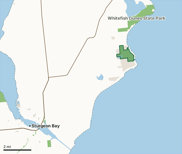
State wildlife areas, forests and other DNR landState parksOther county, city and regional landLand trusts and other open landCave Point-Clay Banks State Natural AreaCounty lineLakeHighway
| Size | 473 acres |
|---|---|
| County | Door County |
| Deer Management Unit | Door County |
| DNR lists for hunting | deer |
| Public access (DNR) | Open to Hiking, Fishing, Hunting and Trapping |
| DNR property page | Cave Point-Clay Banks |
| Nearest towns | Sturgeon Bay (8 mi), Egg Harbor (11 mi) and Baileys Harbor (12 mi) |
What is Cave Point-Clay Banks State Natural Area like?
Three units, Kellner Fen, Shivering Sands, and Sturgeon Bay comprise the SNA. Located along the Lake Michigan shoreline, Cave Point-Clay Banks is an extensive complex of coastal wetlands that supports many unique plants and animals. Lakeshore, open active dunes, ridge and swale topography, embayment lakes and wetlands, and large tracts of mixed conifer-hardwood forest characterize the area. The embayment lakes and wetlands were formed thousands of years ago along the Door Peninsula coastline when a series of ancient Lake Michigan bays were closed off through sand and cobble deposition from longshore currents. As a result of the deposition, ridges and swales along with calcareous fens and high-quality forested wetlands are found here today. Kellner Fen is an embayment wetland similar to other near-shore lakes on the Door Peninsula.
The Shivering Sands Unit encompasses many geologic and natural elements to form a contiguous and complex landscape. Large tracts of lowland coniferous forest grade to upland stands of mixed northern hardwood/conifer forest. A complex hydrologic pattern is manifest by numerous springs that emanate from the dolomite bedrock. Small streams thread through the area and both feed and drain the site. Substrates of peat, marl, sand, loam, and dolostone bedrock underlie the mosaic of forest and wetland. Surrounding three undeveloped lakes is an extensive wet-mesic forest of white cedar, tamarack, alder, and balsam fir. Abundant puddles, pools, and ponds saturate the forest. The lakes contain dense expanses of emergent vegetation that provide excellent habitats for nesting waterfowl and wading birds.
In the DNR's words, from its page for the property.
What can you hunt on Cave Point-Clay Banks State Natural Area?
The DNR's page for Cave Point-Clay Banks State Natural Area names deer. Each follows Wisconsin's statewide season and, for deer, the tags and rules of the deer management unit.
What are the rules on Cave Point-Clay Banks State Natural Area?
The DNR's property map lists Cave Point-Clay Banks State Natural Area as "Open to Hiking, Fishing, Hunting and Trapping". Hunting follows Wisconsin's statewide seasons and the rules posted on the property.
How many deer are taken around Cave Point-Clay Banks State Natural Area?
Cave Point-Clay Banks State Natural Area lies in Door County. The DNR registered 4,302 deer in Door County in 2025, against 4,225 in 2024.
| DMU | Cave Point-Clay Banks State Natural Area acres in it | Deer, 2025 | Deer, 2024 | Deer, 2023 |
|---|---|---|---|---|
| Door County | 473 | 4,302 | 4,225 | 3,793 |
Harvest for the whole deer management unit, not the property alone: Wisconsin DNR Deer Metrics (registered harvest by deer management unit).
How do you get to Cave Point-Clay Banks State Natural Area?
Nearest towns: Sturgeon Bay (8 miles), Egg Harbor (11 miles), Baileys Harbor (12 miles) and Little Sturgeon (17 miles). Highways within 5 miles: WI 57.
What other public land is near Cave Point-Clay Banks State Natural Area?
DNR properties within 10 miles:
- Whitefish Dunes State Park: 868 acres, 1 mile away
- Ahnapee State Trail: 591 acres, 6.6 miles away
- Big Creek State Habitat Area: 20 acres, 6.8 miles away
- Strawberry Creek State Habitat Area: 74 acres, 7.6 miles away
- Potawatomi State Park: 1,098 acres, 8.5 miles away
Public land within 3 miles of Cave Point-Clay Banks State Natural Area
Counting Cave Point-Clay Banks State Natural Area itself, 1,904 of the 26,259 acres within 3 miles of its boundary are public land open to the public (7.3%), by USGS PAD-US 4.1 (fee land open to the public).
| Manager | Acres within 3 miles |
|---|---|
| State wildlife areas, forests and other DNR land | 1,216 |
| Land trusts and other open land | 679 |
| State parks | 9 |
Questions hunters ask
Where is Cave Point-Clay Banks State Natural Area?
In Door County, 8 miles from Sturgeon Bay. The DNR's property page has its maps and parking.
Is Cave Point-Clay Banks State Natural Area open to hunting?
Yes. The DNR's property map lists it as "Open to Hiking, Fishing, Hunting and Trapping". Posted refuges or closed areas, where there are any, are marked on site.
Which deer management unit is Cave Point-Clay Banks State Natural Area in?
Door County.
How much public land is around Cave Point-Clay Banks State Natural Area?
1,904 acres within 3 miles of its boundary, Cave Point-Clay Banks State Natural Area included, by PAD-US 4.1. The closest other DNR property is Whitefish Dunes State Park (1 mile).
Get a Wisconsin hunt plan when they open
Hunt plans for Wisconsin are coming. Join the list and you'll hear first. The first 50 hunters in each new state get their plan free.
Until then, the free FilledTag app for iPhone has a map that works in every state, Wisconsin included.
Where these facts come from
- Area description, species, rules and directions: DNR, Cave Point-Clay Banks State Natural Area; Wisconsin DNR managed lands open to hunting.
- Boundary and acres: the DNR's map layer above. Surrounding public land: USGS PAD-US 4.1 (fee land open to the public).
- Deer harvest: Wisconsin DNR Deer Metrics (registered harvest by deer management unit).
FilledTag is not part of the Wisconsin Department of Natural Resources. Check the DNR's rules and posted signs before you go.