Whitefish Dunes State Park: hunting and access
Whitefish Dunes State Park is 868 acres of land managed by the Wisconsin DNR in Door County, 9 miles from Egg Harbor. Hunters registered 4,302 deer in Door County in 2025.
Data updated October 2026. Area facts: the DNR's DNR property data, read 2026-10. Harvest: DNR Deer Metrics.
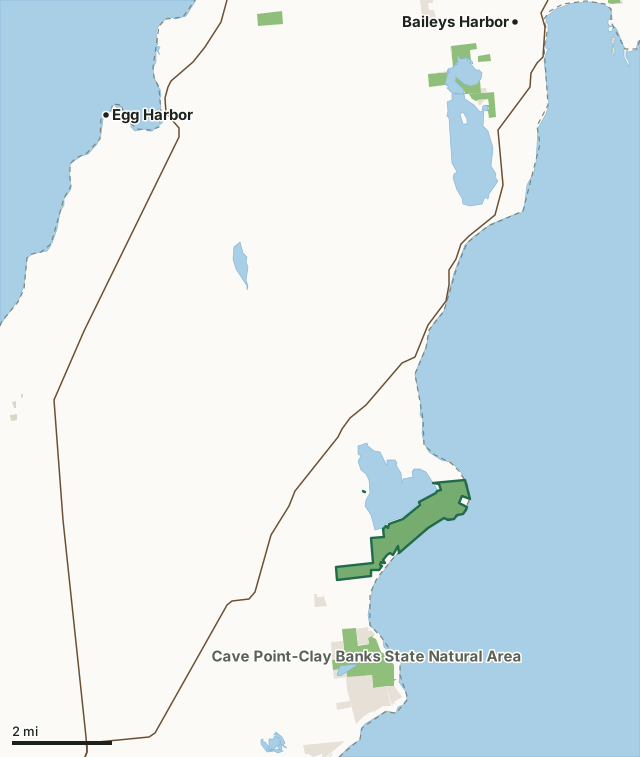
State wildlife areas, forests and other DNR landOther federal landState parksOther county, city and regional landLand trusts and other open landWhitefish Dunes State ParkCounty lineLakeHighway
| Size | 868 acres in 2 pieces |
|---|---|
| County | Door County |
| Deer Management Unit | Door County |
| Public access (DNR) | Open to Hiking, Fishing, Hunting and Trapping |
| DNR property page | Whitefish Dunes |
| Nearest towns | Egg Harbor (9 mi), Baileys Harbor (9 mi) and Sturgeon Bay (9 mi) |
What is Whitefish Dunes State Park like?
Whitefish Dunes State Park protects the fragile dune environment on the eastern Door County Peninsula. At this day-use park, stroll along Lake Michigan or on one of the many trails throughout the huge sand dunes and forest. A nature center features year-round programs, exhibits and displays. The park's reservable picnic shelter overlooks Lake Michigan and is adjacent to the nature center, beach and hiking trails.
In the DNR's words, from its page for the property.
What are the rules on Whitefish Dunes State Park?
The DNR's property map lists Whitefish Dunes State Park as "Open to Hiking, Fishing, Hunting and Trapping". Hunting follows Wisconsin's statewide seasons and the rules posted on the property.
In Wisconsin state parks and recreation areas, hunting is limited to the seasons and the parts of the property the DNR sets for each one; the DNR's page has the details.
How many deer are taken around Whitefish Dunes State Park?
Whitefish Dunes State Park lies in Door County. The DNR registered 4,302 deer in Door County in 2025, against 4,225 in 2024.
| DMU | Whitefish Dunes State Park acres in it | Deer, 2025 | Deer, 2024 | Deer, 2023 |
|---|---|---|---|---|
| Door County | 865 | 4,302 | 4,225 | 3,793 |
Harvest for the whole deer management unit, not the property alone: Wisconsin DNR Deer Metrics (registered harvest by deer management unit).
How do you get to Whitefish Dunes State Park?
Nearest towns: Egg Harbor (9 miles), Baileys Harbor (9 miles), Sturgeon Bay (9 miles) and Ephraim (16 miles). Highways within 5 miles: WI 57.
What other public land is near Whitefish Dunes State Park?
DNR properties within 10 miles:
- Cave Point-Clay Banks State Natural Area: 473 acres, 1 mile away
- Ahnapee State Trail: 591 acres, 7.8 miles away
- Big Creek State Habitat Area: 20 acres, 8.2 miles away
- Strawberry Creek State Habitat Area: 74 acres, 9.2 miles away
Public land within 3 miles of Whitefish Dunes State Park
Counting Whitefish Dunes State Park itself, 1,964 of the 34,307 acres within 3 miles of its boundary are public land open to the public (5.7%), by USGS PAD-US 4.1 (fee land open to the public).
| Manager | Acres within 3 miles |
|---|---|
| State wildlife areas, forests and other DNR land | 1,384 |
| Land trusts and other open land | 567 |
| State parks | 13 |
Questions hunters ask
Where is Whitefish Dunes State Park?
In Door County, 9 miles from Egg Harbor. The DNR's property page has its maps and parking.
Is Whitefish Dunes State Park open to hunting?
Yes. The DNR's property map lists it as "Open to Hiking, Fishing, Hunting and Trapping". Posted refuges or closed areas, where there are any, are marked on site.
Which deer management unit is Whitefish Dunes State Park in?
Door County.
How much public land is around Whitefish Dunes State Park?
1,964 acres within 3 miles of its boundary, Whitefish Dunes State Park included, by PAD-US 4.1. The closest other DNR property is Cave Point-Clay Banks State Natural Area (1 mile).
Get a Wisconsin hunt plan when they open
Hunt plans for Wisconsin are coming. Join the list and you'll hear first. The first 50 hunters in each new state get their plan free.
Until then, the free FilledTag app for iPhone has a map that works in every state, Wisconsin included.
Where these facts come from
- Area description, species, rules and directions: DNR, Whitefish Dunes State Park; Wisconsin DNR managed lands open to hunting.
- Boundary and acres: the DNR's map layer above. Surrounding public land: USGS PAD-US 4.1 (fee land open to the public).
- Deer harvest: Wisconsin DNR Deer Metrics (registered harvest by deer management unit).
FilledTag is not part of the Wisconsin Department of Natural Resources. Check the DNR's rules and posted signs before you go.