Clover Valley State Habitat Area: hunting and access
Clover Valley State Habitat Area is 636 acres of land managed by the Wisconsin DNR in Walworth and Rock counties, 3 miles from Lake Lorraine. The DNR's page for it names deer, ducks and geese, woodcock and small game among the game here. Hunters registered 2,132 deer in Walworth County in 2025.
Data updated October 2026. Area facts: the DNR's DNR property data, read 2026-10. Harvest: DNR Deer Metrics.
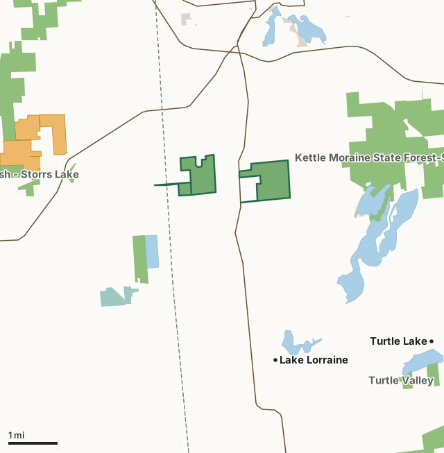
State wildlife areas, forests and other DNR landNational wildlife refuges and waterfowl production areasOther federal landOther county, city and regional landLand trusts and other open landVoluntary Public Access landClover Valley State Habitat AreaCounty lineLakeHighway
| Size | 636 acres in 3 pieces |
|---|---|
| Counties | Walworth County and Rock County |
| Deer Management Unit | Walworth County |
| DNR lists for hunting | deer, ducks and geese, woodcock and small game |
| Public access (DNR) | Open to Hiking, Fishing, Hunting and Trapping |
| DNR property page | Clover Valley Wildlife Area |
| Nearest towns | Lake Lorraine (3 mi), Whitewater (3 mi) and Turtle Lake (4 mi) |
What is Clover Valley State Habitat Area like?
Clover Valley Wildlife Area is a 619-acre property (with additional acres leased) located 2 miles south of Whitewater in Walworth County. The property hosts a segment of the Ice Age Trail with a habitat consisting of wetlands, grasslands and hardwood forest. Brook Creek meanders through the Island Road parcel. Wetlands provide waterfowl hunting opportunities, and uplands provide deer, woodcock and small game opportunities. Many non-game species frequent the area, especially the wetlands. Clover Valley Wildlife Area is managed to maintain or enhance the forested wetlands and open uplands. Forestry management primarily includes timber harvest, tree planting, forestry mowing, herbicide to control invasive species, and occasional prescribed fire.
The uplands off Highway 89 are managed with a cooperative agreement to graze during the growing season. The grazing area is segmented off into small paddocks (~5 acres) and cattle are moved frequently in order to intensively graze a small area and then move on to allow the herbaceous vegetation to recover. This approach aids in weed control, reduces woody species establishment, and invigorates the grassland vegetation while still allowing year-round use by wildlife species. These areas are open to public use year-round, please respect our infrastructure and do not harass the cattle while they are on-site. The Clover Valley Wildlife Area offers many recreational opportunities:.
In the DNR's words, from its page for the property.
What can you hunt on Clover Valley State Habitat Area?
The DNR's page for Clover Valley State Habitat Area names deer, ducks and geese, woodcock and small game. Each follows Wisconsin's statewide season and, for deer, the tags and rules of the deer management unit.
What are the rules on Clover Valley State Habitat Area?
The DNR's property map lists Clover Valley State Habitat Area as "Open to Hiking, Fishing, Hunting and Trapping". Hunting follows Wisconsin's statewide seasons and the rules posted on the property.
Activities the DNR lists for Clover Valley State Habitat Area: Birding, Camping (only in designated Dispersed Camping Area on Ice Age Trail), Cross-country skiing (no designated trail, Hiking (non-designated trails and the Ice Age Trail), Hunting ( Note : some areas along Ice Age Trail are closed to hunting), Trapping ( Note : some areas along Ice Age Trail are closed to trapping), Wild edibles/gathering (wild rice) and Wildlife viewing.
How many deer are taken around Clover Valley State Habitat Area?
Clover Valley State Habitat Area lies in Walworth County. The DNR registered 2,132 deer in Walworth County in 2025, against 2,059 in 2024.
| DMU | Clover Valley State Habitat Area acres in it | Deer, 2025 | Deer, 2024 | Deer, 2023 |
|---|---|---|---|---|
| Walworth County | 635 | 2,132 | 2,059 | 1,881 |
Harvest for the whole deer management unit, not the property alone: Wisconsin DNR Deer Metrics (registered harvest by deer management unit).
How do you get to Clover Valley State Habitat Area?
Nearest towns: Lake Lorraine (3 miles), Whitewater (3 miles), Turtle Lake (4 miles) and Lauderdale Lakes (8 miles). Highways within 5 miles: WI 89, WI 59 and US 12. 3 VPA properties within 3 miles.
What other public land is near Clover Valley State Habitat Area?
DNR properties within 10 miles:
- Clover Valley Fen State Natural Area: 66 acres, 1.1 miles away
- Kettle Moraine State Forest-Southern Unit: 21,556 acres, 1.2 miles away
- Lima Marsh - Storrs Lake Wildlife Area: 2,988 acres, 2.3 miles away
- Turtle Valley Wildlife Area: 2,292 acres, 4.2 miles away
- Prince's Point Wildlife Area: 3,979 acres, 6.6 miles away
Public land within 3 miles of Clover Valley State Habitat Area
Counting Clover Valley State Habitat Area itself, 3,015 of the 31,781 acres within 3 miles of its boundary are public land open to the public (9.5%), by USGS PAD-US 4.1 (fee land open to the public).
| Manager | Acres within 3 miles |
|---|---|
| State wildlife areas, forests and other DNR land | 2,751 |
| National wildlife refuges and waterfowl production areas | 131 |
| Other county, city and regional land | 68 |
| Land trusts and other open land | 64 |
| Other federal land | 1 |
Questions hunters ask
Where is Clover Valley State Habitat Area?
In Walworth and Rock counties, 3 miles from Lake Lorraine. The DNR's property page has its maps and parking.
Is Clover Valley State Habitat Area open to hunting?
Yes. The DNR's property map lists it as "Open to Hiking, Fishing, Hunting and Trapping". Posted refuges or closed areas, where there are any, are marked on site.
Which deer management unit is Clover Valley State Habitat Area in?
Walworth County.
How much public land is around Clover Valley State Habitat Area?
3,015 acres within 3 miles of its boundary, Clover Valley State Habitat Area included, by PAD-US 4.1. The closest other DNR property is Clover Valley Fen State Natural Area (1.1 miles).
Get a Wisconsin hunt plan when they open
Hunt plans for Wisconsin are coming. Join the list and you'll hear first. The first 50 hunters in each new state get their plan free.
Until then, the free FilledTag app for iPhone has a map that works in every state, Wisconsin included.
Where these facts come from
- Area description, species, rules and directions: DNR, Clover Valley State Habitat Area; Wisconsin DNR managed lands open to hunting.
- Boundary and acres: the DNR's map layer above. Surrounding public land: USGS PAD-US 4.1 (fee land open to the public).
- Deer harvest: Wisconsin DNR Deer Metrics (registered harvest by deer management unit).
FilledTag is not part of the Wisconsin Department of Natural Resources. Check the DNR's rules and posted signs before you go.
Wisconsin hunting Walworth County Rock County Walworth County