Coon Creek Fishery Area: hunting and access
Coon Creek Fishery Area is 1,187 acres of land managed by the Wisconsin DNR in Vernon, Monroe and La Crosse counties, next to Coon Valley. The DNR's page for it names deer, wild turkey, ducks and geese, woodcock and rabbits and squirrels among the game here. Hunters registered 9,561 deer in Vernon County in 2025.
Data updated October 2026. Area facts: the DNR's DNR property data, read 2026-10. Harvest: DNR Deer Metrics.
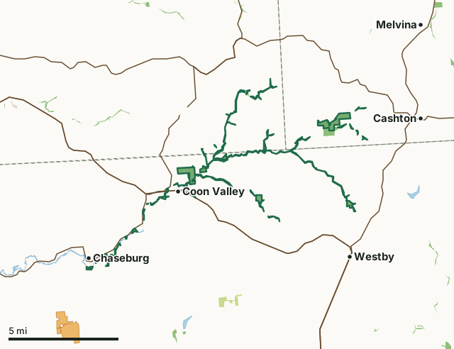
State wildlife areas, forests and other DNR landCounty forestOther county, city and regional landVoluntary Public Access landCoon Creek Fishery AreaCounty lineLakeHighway
| Size | 1,187 acres in 33 pieces |
|---|---|
| Counties | Vernon County, Monroe County and La Crosse County |
| Deer Management Unit | Vernon County, DMU Monroe, La Crosse County |
| DNR lists for hunting | deer, wild turkey, ducks and geese, woodcock and rabbits and squirrels |
| Public access (DNR) | Open to Hiking, Fishing, Hunting and Trapping |
| DNR property page | Coon Creek Fishery Area |
| Nearest towns | Coon Valley (next to it), Chaseburg (next to it) and Westby (2 mi) |
What is Coon Creek Fishery Area like?
The Coon Creek Fishery Area comprises several properties in Vernon, Monroe, and La Crosse County along Coon Creek and its tributaries. Included are sub-properties Bohemian Valley (La Crosse County), Rullands Coulee (Monroe County), and parcels adjacent to Chaseburg, along State Hwy 162 and Koll Road, along Spring Coulee, and along Timber Coulee (Vernon County). Coon Creek, Bohemian Valley Creek, Timber Coulee Creek, Spring Coulee Creek, and Rulland Creek are all class 1 trout streams. The upland habitat consists of a mix of hardwoods, pine, and underbrush. Deer, squirrels, wild turkeys, cottontail rabbits, wood ducks, and woodcock are game species that inhabit the area.
Coon Creek Fishery Area includes several parcels in northeast Vernon County along State Hwy 162 and County Hwy P, in southwest Monroe County along Oakdale Avenue, and in southeast La Crosse County along County Hwy G. The Coon Creek Fishery Area is managed to protect the public trust, enhance coldwater fishery (game and non-game), and provide outdoor recreational opportunities.
In the DNR's words, from its page for the property.
What can you hunt on Coon Creek Fishery Area?
The DNR's page for Coon Creek Fishery Area names deer, wild turkey, ducks and geese, woodcock and rabbits and squirrels. Each follows Wisconsin's statewide season and, for deer, the tags and rules of the deer management unit.
What are the rules on Coon Creek Fishery Area?
The DNR's property map lists Coon Creek Fishery Area as "Open to Hiking, Fishing, Hunting and Trapping". Hunting follows Wisconsin's statewide seasons and the rules posted on the property.
Activities the DNR lists for Coon Creek Fishery Area: Hunting, Trapping, Hiking, Wildlife viewing, Fishing, Bird watching and Berry and Mushroom Picking.
How many deer are taken around Coon Creek Fishery Area?
Coon Creek Fishery Area lies in 3 deer management units. The DNR registered 9,561 deer in Vernon County in 2025, against 9,000 in 2024.
| DMU | Coon Creek Fishery Area acres in it | Deer, 2025 | Deer, 2024 | Deer, 2023 |
|---|---|---|---|---|
| Vernon County | 715 | 9,561 | 9,000 | 8,787 |
| DMU Monroe | 322 | 8,137 | ||
| La Crosse County | 151 | 4,515 | 4,039 | 4,086 |
Harvest for the whole deer management unit, not the property alone: Wisconsin DNR Deer Metrics (registered harvest by deer management unit).
How do you get to Coon Creek Fishery Area?
Nearest towns: Coon Valley (next to it), Chaseburg (next to it), Westby (2 miles) and Cashton (3 miles). Highways within 5 miles: WI 162, WI 33, US 61, US 14 and WI 27. 1 VPA property within 3 miles.
What other public land is near Coon Creek Fishery Area?
DNR properties within 10 miles:
- La Crosse Area Comprehensive Fishery Area: 2,495 acres, next to it
- Eureka Maple Woods State Natural Area: 114 acres, next to it
- Pinnacle Rock Rearing Station: 55 acres, 4.3 miles away
- Coulee Experimental State Forest: 2,964 acres, 5.4 miles away
Public land within 3 miles of Coon Creek Fishery Area
Counting Coon Creek Fishery Area itself, 1,319 of the 111,489 acres within 3 miles of its boundary are public land open to the public (1.2%), by USGS PAD-US 4.1 (fee land open to the public).
| Manager | Acres within 3 miles |
|---|---|
| State wildlife areas, forests and other DNR land | 1,319 |
Questions hunters ask
Where is Coon Creek Fishery Area?
In Vernon, Monroe and La Crosse counties, next to Coon Valley. The DNR's property page has its maps and parking.
Is Coon Creek Fishery Area open to hunting?
Yes. The DNR's property map lists it as "Open to Hiking, Fishing, Hunting and Trapping". Posted refuges or closed areas, where there are any, are marked on site.
Which deer management unit is Coon Creek Fishery Area in?
Vernon County (715 acres), DMU Monroe (322 acres) and La Crosse County (151 acres).
How much public land is around Coon Creek Fishery Area?
1,319 acres within 3 miles of its boundary, Coon Creek Fishery Area included, by PAD-US 4.1. The closest other DNR property is La Crosse Area Comprehensive Fishery Area (next to it).
Get a Wisconsin hunt plan when they open
Hunt plans for Wisconsin are coming. Join the list and you'll hear first. The first 50 hunters in each new state get their plan free.
Until then, the free FilledTag app for iPhone has a map that works in every state, Wisconsin included.
Where these facts come from
- Area description, species, rules and directions: DNR, Coon Creek Fishery Area; Wisconsin DNR managed lands open to hunting.
- Boundary and acres: the DNR's map layer above. Surrounding public land: USGS PAD-US 4.1 (fee land open to the public).
- Deer harvest: Wisconsin DNR Deer Metrics (registered harvest by deer management unit).
FilledTag is not part of the Wisconsin Department of Natural Resources. Check the DNR's rules and posted signs before you go.
Wisconsin hunting Vernon County Monroe County La Crosse County Vernon County La Crosse County