Dells Of The Wisconsin River State Natural Area: hunting and access
Dells Of The Wisconsin River State Natural Area is 1,304 acres of land managed by the Wisconsin DNR in Adams, Columbia, Juneau and Sauk counties, next to Lake Delton. Hunters registered 6,148 deer in Adams County in 2025.
Data updated October 2026. Area facts: the DNR's DNR property data, read 2026-10. Harvest: DNR Deer Metrics.
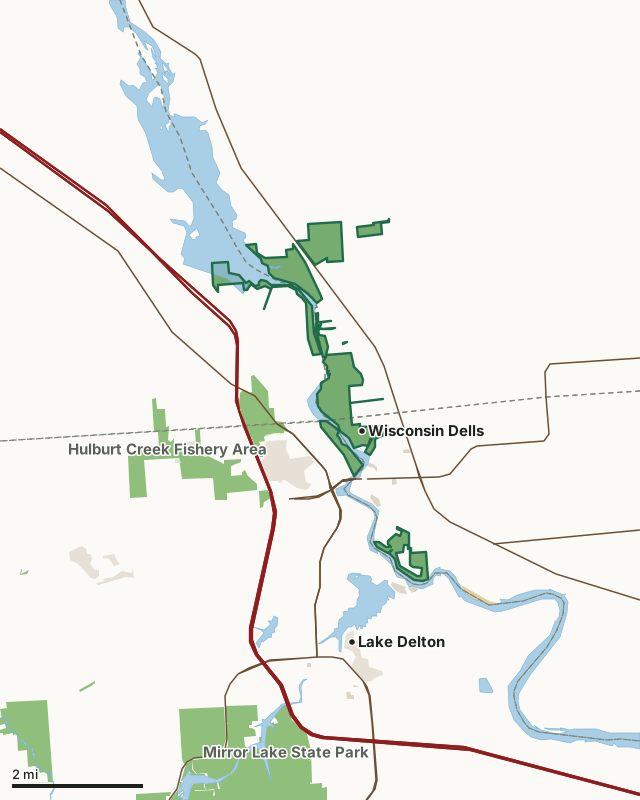
State wildlife areas, forests and other DNR landOther federal landState parksOther county, city and regional landLand trusts and other open landDells Of The Wisconsin River State Natural AreaCounty lineLakeHighway
| Size | 1,304 acres in 14 pieces |
|---|---|
| Counties | Adams County, Columbia County, Juneau County and Sauk County |
| Deer Management Unit | Adams County, Columbia County, DMU Juneau, Sauk County |
| Public access (DNR) | Open to Hiking, Fishing, Hunting and Trapping |
| DNR property page | Dells Of The Wisconsin River |
| Nearest towns | Lake Delton (next to it), Lyndon Station (4 mi) and Briggsville (9 mi) |
What is Dells Of The Wisconsin River State Natural Area like?
The Dells of the Wisconsin River encompasses over five miles of the Wisconsin River corridor with a spectacular gorge, cliffs, tributary canyons and rock formations carved into Cambrian sandstone. Formed between 510-520 million years ago, some cliffs rise over one hundred feet above the water and have been shaped by the erosive processes of water and wind. With a variety of exposures and moisture regimes, the cliffs afford many different niches for plants, some of which are very rare in Wisconsin. One species is known from only two places on Earth - here and in the Kickapoo Valley, and grows on protected rock ledges. Other rarities are also present. This area contains a mosaic of plant communities including northern and southern oak/pine forests, oak savanna, and moist and dry cliffs. Rare animals include six dragonfly species, six rare mussels and numerous birds.
Adams, Columbia, Juneau & Sauk Counties. T13N-R6E, Sections 3, 4, 10, 15, 16. T14N-R6E, Sections 20, 21, 28, 29, 33, 34. 1,386 acres. All parking areas, including the Cambrian Overlook, are fee areas - vehicles parked here must display a valid Wisconsin State Park admission sticker. Several locations afford access to the upland and river portions of the natural area. On the east side of the Wisconsin River, the Chapel Gorge Trail is a 1.5-mile loop trail leading to a shoreline beach amid rock outcrops along the river. To reach the Chapel Gorge Trail: From the intersection of Highways 12 and 13/23 in Wisconsin Dells, go east on 13 0.6 miles (across the river), then north on River Road 1.7 miles to a parking area west of the road. The trail starts at the parking lot. Hiking is also permitted on the network of old maintenance lanes starting at the Crandall Pines parking lot.
In the DNR's words, from its page for the property.
What are the rules on Dells Of The Wisconsin River State Natural Area?
The DNR's property map lists Dells Of The Wisconsin River State Natural Area as "Open to Hiking, Fishing, Hunting and Trapping". Hunting follows Wisconsin's statewide seasons and the rules posted on the property.
How many deer are taken around Dells Of The Wisconsin River State Natural Area?
Dells Of The Wisconsin River State Natural Area lies in 4 deer management units. The DNR registered 6,148 deer in Adams County in 2025, against 6,658 in 2024.
| DMU | Dells Of The Wisconsin River State Natural Area acres in it | Deer, 2025 | Deer, 2024 | Deer, 2023 |
|---|---|---|---|---|
| Adams County | 796 | 6,148 | 6,658 | 5,428 |
| Columbia County | 260 | 7,189 | 7,176 | 6,629 |
| DMU Juneau | 169 | 4,295 | ||
| Sauk County | 79 | 6,025 | 5,739 | 6,262 |
Harvest for the whole deer management unit, not the property alone: Wisconsin DNR Deer Metrics (registered harvest by deer management unit).
How do you get to Dells Of The Wisconsin River State Natural Area?
Nearest towns: Lake Delton (next to it), Lyndon Station (4 miles), Briggsville (9 miles) and West Baraboo (9 miles). Highways within 5 miles: I-90, I-94, US 12, WI 23 and WI 13.
What other public land is near Dells Of The Wisconsin River State Natural Area?
DNR properties within 10 miles:
- Rocky Arbor State Park: 264 acres, 0.5 miles away
- Hulburt Creek Fishery Area: 573 acres, 1.2 miles away
- Mirror Lake State Park: 2,152 acres, 2.7 miles away
- Dell Creek Wildlife Area: 2,710 acres, 4.9 miles away
Public land within 3 miles of Dells Of The Wisconsin River State Natural Area
Counting Dells Of The Wisconsin River State Natural Area itself, 2,688 of the 50,506 acres within 3 miles of its boundary are public land open to the public (5.3%), by USGS PAD-US 4.1 (fee land open to the public).
| Manager | Acres within 3 miles |
|---|---|
| State wildlife areas, forests and other DNR land | 2,239 |
| Land trusts and other open land | 357 |
| Other county, city and regional land | 57 |
| Other federal land | 30 |
| State parks | 5 |
Questions hunters ask
Where is Dells Of The Wisconsin River State Natural Area?
In Adams, Columbia, Juneau and Sauk counties, next to Lake Delton. The DNR's property page has its maps and parking.
Is Dells Of The Wisconsin River State Natural Area open to hunting?
Yes. The DNR's property map lists it as "Open to Hiking, Fishing, Hunting and Trapping". Posted refuges or closed areas, where there are any, are marked on site.
Which deer management unit is Dells Of The Wisconsin River State Natural Area in?
Adams County (796 acres), Columbia County (260 acres), DMU Juneau (169 acres) and Sauk County (79 acres).
How much public land is around Dells Of The Wisconsin River State Natural Area?
2,688 acres within 3 miles of its boundary, Dells Of The Wisconsin River State Natural Area included, by PAD-US 4.1. The closest other DNR property is Rocky Arbor State Park (0.5 miles).
Get a Wisconsin hunt plan when they open
Hunt plans for Wisconsin are coming. Join the list and you'll hear first. The first 50 hunters in each new state get their plan free.
Until then, the free FilledTag app for iPhone has a map that works in every state, Wisconsin included.
Where these facts come from
- Area description, species, rules and directions: DNR, Dells Of The Wisconsin River State Natural Area; Wisconsin DNR managed lands open to hunting.
- Boundary and acres: the DNR's map layer above. Surrounding public land: USGS PAD-US 4.1 (fee land open to the public).
- Deer harvest: Wisconsin DNR Deer Metrics (registered harvest by deer management unit).
FilledTag is not part of the Wisconsin Department of Natural Resources. Check the DNR's rules and posted signs before you go.
Wisconsin hunting Adams County Columbia County Juneau County Sauk County Adams County Columbia County Sauk County