Dunbar Barrens State Natural Area: hunting and access
Dunbar Barrens State Natural Area is 1,412 acres of land managed by the Wisconsin DNR in Marinette County, 3 miles from Dunbar. Hunters registered 2,310 deer in DMU 125 in 2025.
Data updated October 2026. Area facts: the DNR's DNR property data, read 2026-10. Harvest: DNR Deer Metrics.
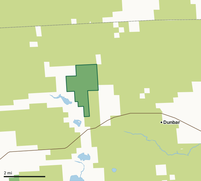
State wildlife areas, forests and other DNR landCounty forestDunbar Barrens State Natural AreaCounty lineLakeHighway
| Size | 1,412 acres |
|---|---|
| County | Marinette County |
| Deer Management Unit | DMU 125 |
| Public access (DNR) | Open to Hiking, Fishing, Hunting and Trapping |
| DNR property page | Dunbar Barrens |
| Nearest towns | Dunbar (3 mi), Goodman (5 mi) and Pembine (12 mi) |
What is Dunbar Barrens State Natural Area like?
Dunbar Barrens features a Pine Barrens community that is part of a large, open landscape located on a gently rolling pitted glacial outwash plain. The site is similar in composition to presettlement barrens with broad sweeping prairie vistas and a distinctive panorama. Logging, grazing and periodic fires have maintained the open character of the barrens in addition to the action of frost in low pockets. Today, aspen, oak and jack pine forest surround the opening and low granitic outcrops are found scattered throughout the area. The dominant vegetation consists of grasses and sedges, and a well-developed shrub layer is present including blueberry, bearberry, prairie willow and sweet fern. Herbaceous plants include rice grass, poverty oat grass, wintergreen, barren strawberry and hawkweeds. The area also harbors a diverse and unusual lichen flora.
Highway 8 and County U west of Dunbar, go west on 8 2.0 miles, then north on an unimproved access road (marked with fire number 12902) 1.3 miles, then west 0.4 miles to the southeast corner of the site. While most SNAs are open to the public, access may vary according to individual ownership policies. Dunbar Barrens is owned by: Wisconsin DNR.
In the DNR's words, from its page for the property.
What are the rules on Dunbar Barrens State Natural Area?
The DNR's property map lists Dunbar Barrens State Natural Area as "Open to Hiking, Fishing, Hunting and Trapping". Hunting follows Wisconsin's statewide seasons and the rules posted on the property.
How many deer are taken around Dunbar Barrens State Natural Area?
Dunbar Barrens State Natural Area lies in DMU 125. The DNR registered 2,310 deer in DMU 125 in 2025.
| DMU | Dunbar Barrens State Natural Area acres in it | Deer, 2025 |
|---|---|---|
| DMU 125 | 1,412 | 2,310 |
Harvest for the whole deer management unit, not the property alone: Wisconsin DNR Deer Metrics (registered harvest by deer management unit).
How do you get to Dunbar Barrens State Natural Area?
Nearest towns: Dunbar (3 miles), Goodman (5 miles), Pembine (12 miles) and Niagara (13 miles). Highways within 5 miles: US 8.
What other public land is near Dunbar Barrens State Natural Area?
DNR properties within 10 miles:
- Wild Rivers/Pine Popple Conservation Easement: 58,880 acres, 3.6 miles away
- Pike Wild River: 4,758 acres, 6.1 miles away
- No Bottom Lake State Habitat Area: 37 acres, 8 miles away
- Spread Eagle Barrens State Natural Area: 7,889 acres, 8.7 miles away
Public land within 3 miles of Dunbar Barrens State Natural Area
Counting Dunbar Barrens State Natural Area itself, 25,939 of the 32,825 acres within 3 miles of its boundary are public land open to the public (79%), by USGS PAD-US 4.1 (fee land open to the public).
| Manager | Acres within 3 miles |
|---|---|
| County forest | 24,525 |
| State wildlife areas, forests and other DNR land | 1,414 |
Questions hunters ask
Where is Dunbar Barrens State Natural Area?
In Marinette County, 3 miles from Dunbar. The DNR's property page has its maps and parking.
Is Dunbar Barrens State Natural Area open to hunting?
Yes. The DNR's property map lists it as "Open to Hiking, Fishing, Hunting and Trapping". Posted refuges or closed areas, where there are any, are marked on site.
Which deer management unit is Dunbar Barrens State Natural Area in?
DMU 125.
How much public land is around Dunbar Barrens State Natural Area?
25,939 acres within 3 miles of its boundary, Dunbar Barrens State Natural Area included, by PAD-US 4.1. The closest other DNR property is Wild Rivers/Pine Popple Conservation Easement (3.6 miles).
Get a Wisconsin hunt plan when they open
Hunt plans for Wisconsin are coming. Join the list and you'll hear first. The first 50 hunters in each new state get their plan free.
Until then, the free FilledTag app for iPhone has a map that works in every state, Wisconsin included.
Where these facts come from
- Area description, species, rules and directions: DNR, Dunbar Barrens State Natural Area; Wisconsin DNR managed lands open to hunting.
- Boundary and acres: the DNR's map layer above. Surrounding public land: USGS PAD-US 4.1 (fee land open to the public).
- Deer harvest: Wisconsin DNR Deer Metrics (registered harvest by deer management unit).
FilledTag is not part of the Wisconsin Department of Natural Resources. Check the DNR's rules and posted signs before you go.