Governor Earl Peshtigo River State Forest: hunting and access
Governor Earl Peshtigo River State Forest is 11,795 acres of land managed by the Wisconsin DNR in Marinette and Oconto counties, 3 miles from Peshtigo. Hunters registered 7,552 deer in DMU Marinette in 2025.
Data updated October 2026. Area facts: the DNR's DNR property data, read 2026-10. Harvest: DNR Deer Metrics.
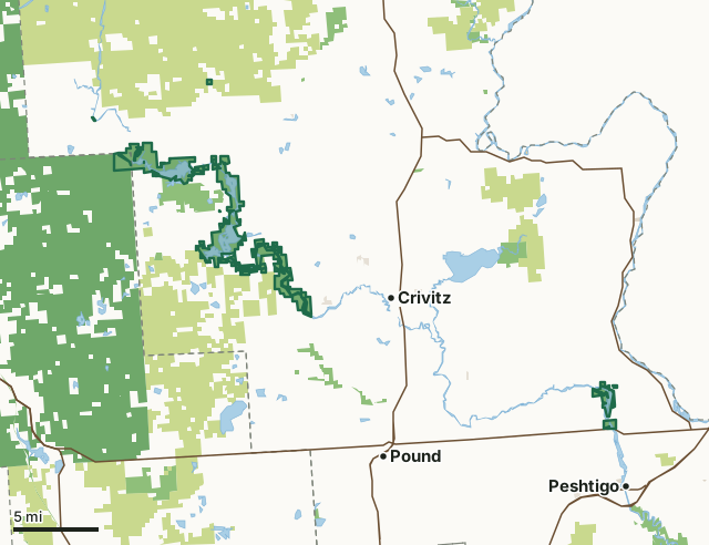
State wildlife areas, forests and other DNR landCounty forestNational forestOther federal landOther county, city and regional landLand trusts and other open landGovernor Earl Peshtigo River State ForestCounty lineLakeHighway
| Size | 11,795 acres in 67 pieces |
|---|---|
| Counties | Marinette County and Oconto County |
| Deer Management Unit | DMU Marinette, DMU 126 |
| Public access (DNR) | Open to Hiking, Fishing, Hunting and Trapping |
| DNR property page | Governor Earl Peshtigo River |
| Nearest towns | Peshtigo (3 mi), Crivitz (5 mi) and Marinette (6 mi) |
What is Governor Earl Peshtigo River State Forest like?
Governor Earl Peshtigo River State Forest is a long, linear state forest in northeast Wisconsin bordering some of the most beautiful and exciting sections of the Peshtigo River. Anglers know the river's free-flowing portion for its excellent fly-fishing; paddlers brave the Midwest's longest continuous whitewater rapids; and boaters can access more than 3,000 acres of flowage from 15 boat landings. The forest offers a family campground and several remote boat-in campsites along the river.
In the DNR's words, from its page for the property.
What are the rules on Governor Earl Peshtigo River State Forest?
The DNR's property map lists Governor Earl Peshtigo River State Forest as "Open to Hiking, Fishing, Hunting and Trapping". Hunting follows Wisconsin's statewide seasons and the rules posted on the property.
How many deer are taken around Governor Earl Peshtigo River State Forest?
Governor Earl Peshtigo River State Forest lies in 2 deer management units. The DNR registered 7,552 deer in DMU Marinette in 2025.
| DMU | Governor Earl Peshtigo River State Forest acres in it | Deer, 2025 |
|---|---|---|
| DMU Marinette | 7,956 | 7,552 |
| DMU 126 | 3,839 | 3,288 |
Harvest for the whole deer management unit, not the property alone: Wisconsin DNR Deer Metrics (registered harvest by deer management unit).
How do you get to Governor Earl Peshtigo River State Forest?
Nearest towns: Peshtigo (3 miles), Crivitz (5 miles), Marinette (6 miles) and Pound (9 miles). Highways within 5 miles: US 41, WI 64 and WI 180.
What other public land is near Governor Earl Peshtigo River State Forest?
DNR properties within 10 miles:
- Governor Thompson State Park: 2,947 acres, next to it
- North Branch Beaver Creek Fishery Area: 1,150 acres, 1.6 miles away
- Thunder River Rearing Station: 136 acres, 2 miles away
- Green Bay West Shores Wildlife Area: 10,056 acres, 4.6 miles away
- Wausaukee River State Habitat Area: 23 acres, 5.2 miles away
Public land within 3 miles of Governor Earl Peshtigo River State Forest
Counting Governor Earl Peshtigo River State Forest itself, 48,073 of the 165,934 acres within 3 miles of its boundary are public land open to the public (29%), by USGS PAD-US 4.1 (fee land open to the public).
| Manager | Acres within 3 miles |
|---|---|
| County forest | 24,073 |
| State wildlife areas, forests and other DNR land | 15,517 |
| National forest | 8,336 |
| Land trusts and other open land | 117 |
| Other federal land | 18 |
| State parks | 10 |
| Other county, city and regional land | 2 |
Questions hunters ask
Where is Governor Earl Peshtigo River State Forest?
In Marinette and Oconto counties, 3 miles from Peshtigo. The DNR's property page has its maps and parking.
Is Governor Earl Peshtigo River State Forest open to hunting?
Yes. The DNR's property map lists it as "Open to Hiking, Fishing, Hunting and Trapping". Posted refuges or closed areas, where there are any, are marked on site.
Which deer management unit is Governor Earl Peshtigo River State Forest in?
DMU Marinette (7,956 acres) and DMU 126 (3,839 acres).
How much public land is around Governor Earl Peshtigo River State Forest?
48,073 acres within 3 miles of its boundary, Governor Earl Peshtigo River State Forest included, by PAD-US 4.1. The closest other DNR property is Governor Thompson State Park (next to it).
Get a Wisconsin hunt plan when they open
Hunt plans for Wisconsin are coming. Join the list and you'll hear first. The first 50 hunters in each new state get their plan free.
Until then, the free FilledTag app for iPhone has a map that works in every state, Wisconsin included.
Where these facts come from
- Area description, species, rules and directions: DNR, Governor Earl Peshtigo River State Forest; Wisconsin DNR managed lands open to hunting.
- Boundary and acres: the DNR's map layer above. Surrounding public land: USGS PAD-US 4.1 (fee land open to the public).
- Deer harvest: Wisconsin DNR Deer Metrics (registered harvest by deer management unit).
FilledTag is not part of the Wisconsin Department of Natural Resources. Check the DNR's rules and posted signs before you go.