Green Bay West Shores Wildlife Area: hunting and access
Green Bay West Shores Wildlife Area is 10,056 acres of land managed by the Wisconsin DNR in Marinette, Oconto and Brown counties, next to Howard. The DNR's page for it names ducks and geese among the game here. Hunters registered 7,552 deer in DMU Marinette in 2025.
Data updated October 2026. Area facts: the DNR's DNR property data, read 2026-10. Harvest: DNR Deer Metrics.
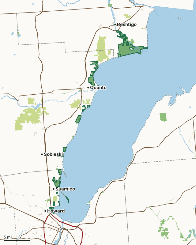
State wildlife areas, forests and other DNR landCounty forestOther county, city and regional landLand trusts and other open landGreen Bay West Shores Wildlife AreaCounty lineLakeHighway
| Size | 10,056 acres in 62 pieces |
|---|---|
| Counties | Marinette County, Oconto County and Brown County |
| Deer Management Unit | DMU Marinette, DMU Oconto, Brown County |
| DNR lists for hunting | ducks and geese |
| Public access (DNR) | Open to Hiking, Fishing, Hunting and Trapping |
| DNR property page | Green Bay West Shores Wildlife Area |
| Nearest towns | Howard (next to it), Suamico (next to it) and Oconto (next to it) |
What is Green Bay West Shores Wildlife Area like?
The Green Bay West Shores Wildlife Area (GBWSWA) is located along the west shore of Green Bay. The west shore has a long history of human occupation. Rivers and the shoreline were used by Native Americans who utilized the resources of the bay and adjacent land. Missions and trading posts were established at several locations on the shore beginning during the French settlement of the area in the 1700s and continuing throughout British and American settlement in the 1800s. The area was logged with lumber mills located at Peshtigo, Oconto and Pensaukee. The west shore supported a commercial fishing industry which continues to the present on a much smaller scale. In some areas, agriculture followed land clearing though poorly drained soils and water level fluctuations present challenges.
Because the shore zone is vitally important to the fish assemblage of Green Bay, properties have been acquired under authority of the Scattered Fishery Habitat acquisition project. These sites have a hydrologic connection to the bay and provide fish spawning and nursery habitat for a variety of fish species, particularly northern pike. Protection of these sites and enhancement of fish habitat and spawning substrate are the primary fish management activities. Learn more about this property's master plan [PDF].
In the DNR's words, from its page for the property.
What can you hunt on Green Bay West Shores Wildlife Area?
The DNR's page for Green Bay West Shores Wildlife Area names ducks and geese. Each follows Wisconsin's statewide season and, for deer, the tags and rules of the deer management unit.
What are the rules on Green Bay West Shores Wildlife Area?
The DNR's property map lists Green Bay West Shores Wildlife Area as "Open to Hiking, Fishing, Hunting and Trapping". Hunting follows Wisconsin's statewide seasons and the rules posted on the property.
How many deer are taken around Green Bay West Shores Wildlife Area?
Green Bay West Shores Wildlife Area lies in 3 deer management units. The DNR registered 7,552 deer in DMU Marinette in 2025.
| DMU | Green Bay West Shores Wildlife Area acres in it | Deer, 2025 |
|---|---|---|
| DMU Marinette | 5,682 | 7,552 |
| DMU Oconto | 2,507 | 7,277 |
| Brown County | 1,826 | 3,627 |
Harvest for the whole deer management unit, not the property alone: Wisconsin DNR Deer Metrics (registered harvest by deer management unit).
How do you get to Green Bay West Shores Wildlife Area?
Nearest towns: Howard (next to it), Suamico (next to it), Oconto (next to it) and Peshtigo (next to it). Highways within 5 miles: US 41, US 141, WI 29, WI 32 and WI 54.
What other public land is near Green Bay West Shores Wildlife Area?
DNR properties within 10 miles:
- Bloch Oxbow State Natural Area: 610 acres, next to it
- Mountain-Bay State Trail: 1,071 acres, next to it
Public land within 3 miles of Green Bay West Shores Wildlife Area
Counting Green Bay West Shores Wildlife Area itself, 19,021 of the 217,861 acres within 3 miles of its boundary are public land open to the public (8.7%), by USGS PAD-US 4.1 (fee land open to the public).
| Manager | Acres within 3 miles |
|---|---|
| State wildlife areas, forests and other DNR land | 11,607 |
| County forest | 6,461 |
| Other county, city and regional land | 812 |
| Land trusts and other open land | 131 |
| Other federal land | 8 |
| State parks | 2 |
Questions hunters ask
Where is Green Bay West Shores Wildlife Area?
In Marinette, Oconto and Brown counties, next to Howard. The DNR's property page has its maps and parking.
Is Green Bay West Shores Wildlife Area open to hunting?
Yes. The DNR's property map lists it as "Open to Hiking, Fishing, Hunting and Trapping". Posted refuges or closed areas, where there are any, are marked on site.
Which deer management unit is Green Bay West Shores Wildlife Area in?
DMU Marinette (5,682 acres), DMU Oconto (2,507 acres) and Brown County (1,826 acres).
How much public land is around Green Bay West Shores Wildlife Area?
19,021 acres within 3 miles of its boundary, Green Bay West Shores Wildlife Area included, by PAD-US 4.1. The closest other DNR property is Bloch Oxbow State Natural Area (next to it).
Get a Wisconsin hunt plan when they open
Hunt plans for Wisconsin are coming. Join the list and you'll hear first. The first 50 hunters in each new state get their plan free.
Until then, the free FilledTag app for iPhone has a map that works in every state, Wisconsin included.
Where these facts come from
- Area description, species, rules and directions: DNR, Green Bay West Shores Wildlife Area; Wisconsin DNR managed lands open to hunting.
- Boundary and acres: the DNR's map layer above. Surrounding public land: USGS PAD-US 4.1 (fee land open to the public).
- Deer harvest: Wisconsin DNR Deer Metrics (registered harvest by deer management unit).
FilledTag is not part of the Wisconsin Department of Natural Resources. Check the DNR's rules and posted signs before you go.
Wisconsin hunting Marinette County Oconto County Brown County Brown County