Bloch Oxbow State Natural Area: hunting and access
Bloch Oxbow State Natural Area is 610 acres of land managed by the Wisconsin DNR in Marinette County, 3 miles from Peshtigo. Hunters registered 7,552 deer in DMU Marinette in 2025.
Data updated October 2026. Area facts: the DNR's DNR property data, read 2026-10. Harvest: DNR Deer Metrics.
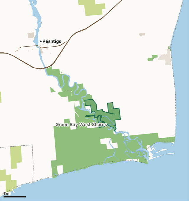
State wildlife areas, forests and other DNR landCounty forestOther federal landOther county, city and regional landLand trusts and other open landBloch Oxbow State Natural AreaCounty lineLakeHighway
| Size | 610 acres in 3 pieces |
|---|---|
| County | Marinette County |
| Deer Management Unit | DMU Marinette |
| Public access (DNR) | Open to Hiking, Fishing, Hunting and Trapping |
| DNR property page | Bloch Oxbow |
| Nearest towns | Peshtigo (3 mi), Marinette (6 mi) and Oconto (11 mi) |
What is Bloch Oxbow State Natural Area like?
Bloch Oxbow lies on a level sandy upland a few feet above the floodplain of the Peshtigo River, 2 miles upstream of its confluence with Green Bay. It protects one of the best remaining examples of northern dry-mesic forest - a type that was formerly widespread in northeastern Wisconsin but is now reduced to small, often degraded remnants. Canopy dominants are red oak and red maple with super canopy white pine to 36 inches d.b.h. Characteristic shrubs include hazelnut, witch hazel, huckleberry, blueberry and withered an uncommon shrub species. Prevalent herbaceous plants are bracken fern, interrupted fern, Canada mayflower, wild sarsaparilla, and large-leaved aster. Bordering the Peshtigo River is a floodplain forest at the extreme northeastern edge of its range in Wisconsin. Dominants include silver maple with green ash, elm, basswood, bitternut hickory, cottonwood, and black willow.
The ground layer is primarily bracken fern with ericaceous species and Pennsylvania sedge. Widely scattered, very old, charred stumps are evident in the area and may remain from the historic Peshtigo fire of 1871. The natural area is critical habitat for several sensitive bird species. A great blue heron rookery and a large colony of bank swallows are also found here. Bloch Oxbow is owned by the DNR and was designated a State Natural Area in 1990. Marinette County. T29N-R23E, Sections 3, 4, 9, 10. 610 acres. From the junction of U.S. Highway 41 and County Highway B in Peshtigo, go south on B for 1.3 miles, then south on County Highway BB for 2.8 miles to a parking area east side of the road. The best pines are east of BB.
In the DNR's words, from its page for the property.
What are the rules on Bloch Oxbow State Natural Area?
The DNR's property map lists Bloch Oxbow State Natural Area as "Open to Hiking, Fishing, Hunting and Trapping". Hunting follows Wisconsin's statewide seasons and the rules posted on the property.
How many deer are taken around Bloch Oxbow State Natural Area?
Bloch Oxbow State Natural Area lies in DMU Marinette. The DNR registered 7,552 deer in DMU Marinette in 2025.
| DMU | Bloch Oxbow State Natural Area acres in it | Deer, 2025 |
|---|---|---|
| DMU Marinette | 610 | 7,552 |
Harvest for the whole deer management unit, not the property alone: Wisconsin DNR Deer Metrics (registered harvest by deer management unit).
How do you get to Bloch Oxbow State Natural Area?
Nearest towns: Peshtigo (3 miles), Marinette (6 miles), Oconto (11 miles) and Little Sturgeon (12 miles). Highways within 5 miles: US 41.
What other public land is near Bloch Oxbow State Natural Area?
DNR properties within 10 miles:
- Green Bay West Shores Wildlife Area: 10,056 acres, next to it
- Habitat Area: 62 acres, 2.4 miles away
- Little River State Habitat Area: 32 acres, 2.7 miles away
- Seagull Bar State Natural Area: 43 acres, 6.3 miles away
- Governor Earl Peshtigo River State Forest: 11,795 acres, 6.5 miles away
Public land within 3 miles of Bloch Oxbow State Natural Area
Counting Bloch Oxbow State Natural Area itself, 6,410 of the 28,780 acres within 3 miles of its boundary are public land open to the public (22.3%), by USGS PAD-US 4.1 (fee land open to the public).
| Manager | Acres within 3 miles |
|---|---|
| State wildlife areas, forests and other DNR land | 6,359 |
| Land trusts and other open land | 34 |
| Other county, city and regional land | 13 |
| Other federal land | 4 |
Questions hunters ask
Where is Bloch Oxbow State Natural Area?
In Marinette County, 3 miles from Peshtigo. The DNR's property page has its maps and parking.
Is Bloch Oxbow State Natural Area open to hunting?
Yes. The DNR's property map lists it as "Open to Hiking, Fishing, Hunting and Trapping". Posted refuges or closed areas, where there are any, are marked on site.
Which deer management unit is Bloch Oxbow State Natural Area in?
DMU Marinette.
How much public land is around Bloch Oxbow State Natural Area?
6,410 acres within 3 miles of its boundary, Bloch Oxbow State Natural Area included, by PAD-US 4.1. The closest other DNR property is Green Bay West Shores Wildlife Area (next to it).
Get a Wisconsin hunt plan when they open
Hunt plans for Wisconsin are coming. Join the list and you'll hear first. The first 50 hunters in each new state get their plan free.
Until then, the free FilledTag app for iPhone has a map that works in every state, Wisconsin included.
Where these facts come from
- Area description, species, rules and directions: DNR, Bloch Oxbow State Natural Area; Wisconsin DNR managed lands open to hunting.
- Boundary and acres: the DNR's map layer above. Surrounding public land: USGS PAD-US 4.1 (fee land open to the public).
- Deer harvest: Wisconsin DNR Deer Metrics (registered harvest by deer management unit).
FilledTag is not part of the Wisconsin Department of Natural Resources. Check the DNR's rules and posted signs before you go.