Kettle Moraine State Forest-Northern Unit: hunting and access
Kettle Moraine State Forest-Northern Unit is 30,281 acres of land managed by the Wisconsin DNR in Sheboygan, Fond du Lac and Washington counties, next to Glenbeulah. Hunters registered 3,562 deer in Sheboygan County in 2025.
Data updated October 2026. Area facts: the DNR's DNR property data, read 2026-10. Harvest: DNR Deer Metrics.
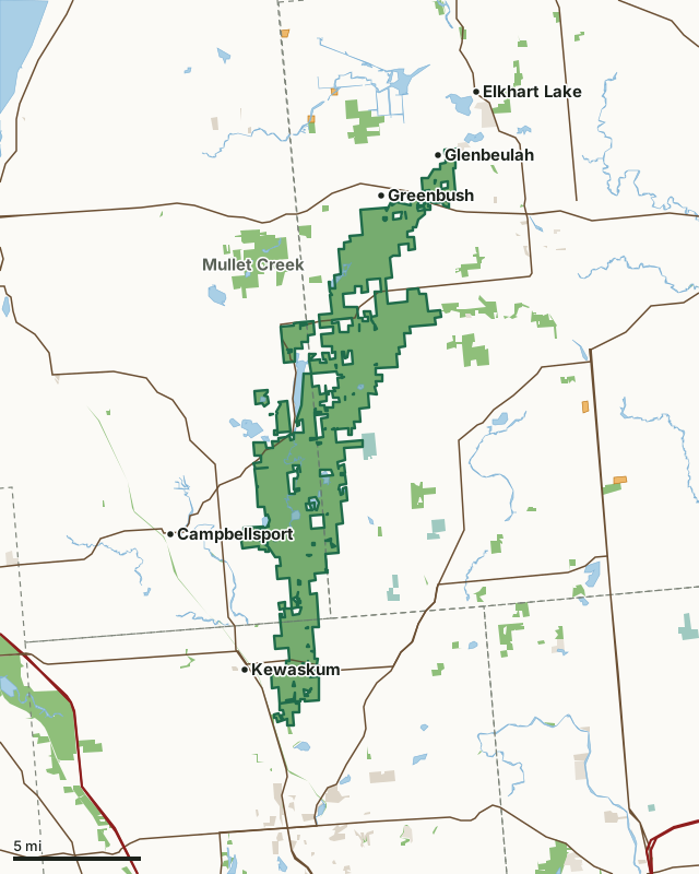
State wildlife areas, forests and other DNR landNational wildlife refuges and waterfowl production areasOther county, city and regional landLand trusts and other open landVoluntary Public Access landKettle Moraine State Forest-Northern UnitCounty lineLakeHighway
| Size | 30,281 acres in 11 pieces |
|---|---|
| Counties | Sheboygan County, Fond du Lac County and Washington County |
| Deer Management Unit | Sheboygan County, Fond du Lac County, Washington County |
| Public access (DNR) | Open to Hiking, Fishing, Hunting and Trapping |
| DNR property page | Northern Unit |
| Nearest towns | Glenbeulah (next to it), Greenbush (next to it) and Kewaskum (next to it) |
What is Kettle Moraine State Forest-Northern Unit like?
The first and largest unit of the Kettle Moraine State Forest offers year-round recreation among world-famous glacial landforms. Visitors can swim at three beaches, enjoy challenging mountain biking trails or groomed ski trails, hike the Ice Age Trail, take in a nature program, or just escape among 30,000 acres of rolling, wooded hills and prairies. The Henry S. Reuss Ice Age Visitor Center includes an exhibit area, auditorium and gift shop. The forest has over 350 campsites, including standard, group, equestrian and backpack opportunities.
In the DNR's words, from its page for the property.
What are the rules on Kettle Moraine State Forest-Northern Unit?
The DNR's property map lists Kettle Moraine State Forest-Northern Unit as "Open to Hiking, Fishing, Hunting and Trapping". Hunting follows Wisconsin's statewide seasons and the rules posted on the property.
How many deer are taken around Kettle Moraine State Forest-Northern Unit?
Kettle Moraine State Forest-Northern Unit lies in 3 deer management units. The DNR registered 3,562 deer in Sheboygan County in 2025, against 3,536 in 2024.
| DMU | Kettle Moraine State Forest-Northern Unit acres in it | Deer, 2025 | Deer, 2024 | Deer, 2023 |
|---|---|---|---|---|
| Sheboygan County | 16,290 | 3,562 | 3,536 | 3,251 |
| Fond du Lac County | 10,873 | 4,642 | 4,546 | 4,068 |
| Washington County | 3,120 | 3,731 | 3,427 | 2,972 |
Harvest for the whole deer management unit, not the property alone: Wisconsin DNR Deer Metrics (registered harvest by deer management unit).
How do you get to Kettle Moraine State Forest-Northern Unit?
Nearest towns: Glenbeulah (next to it), Greenbush (next to it), Kewaskum (next to it) and Elkhart Lake (2 miles). Highways within 5 miles: WI 67, US 45, WI 28, WI 23 and WI 144.
What other public land is near Kettle Moraine State Forest-Northern Unit?
DNR properties within 10 miles:
- State Ice Age Trail Area (SIATA): 4,676 acres, next to it
- Onion River Streambank Protection Area: 1,017 acres, next to it
- Eisenbahn State Trail: 296 acres, next to it
Public land within 3 miles of Kettle Moraine State Forest-Northern Unit
Counting Kettle Moraine State Forest-Northern Unit itself, 36,309 of the 164,527 acres within 3 miles of its boundary are public land open to the public (22.1%), by USGS PAD-US 4.1 (fee land open to the public).
| Manager | Acres within 3 miles |
|---|---|
| State wildlife areas, forests and other DNR land | 35,076 |
| National wildlife refuges and waterfowl production areas | 497 |
| Land trusts and other open land | 433 |
| Other county, city and regional land | 297 |
| State parks | 6 |
Questions hunters ask
Where is Kettle Moraine State Forest-Northern Unit?
In Sheboygan, Fond du Lac and Washington counties, next to Glenbeulah. The DNR's property page has its maps and parking.
Is Kettle Moraine State Forest-Northern Unit open to hunting?
Yes. The DNR's property map lists it as "Open to Hiking, Fishing, Hunting and Trapping". Posted refuges or closed areas, where there are any, are marked on site.
Which deer management unit is Kettle Moraine State Forest-Northern Unit in?
Sheboygan County (16,290 acres), Fond du Lac County (10,873 acres) and Washington County (3,120 acres).
How much public land is around Kettle Moraine State Forest-Northern Unit?
36,309 acres within 3 miles of its boundary, Kettle Moraine State Forest-Northern Unit included, by PAD-US 4.1. The closest other DNR property is State Ice Age Trail Area (SIATA) (next to it).
Get a Wisconsin hunt plan when they open
Hunt plans for Wisconsin are coming. Join the list and you'll hear first. The first 50 hunters in each new state get their plan free.
Until then, the free FilledTag app for iPhone has a map that works in every state, Wisconsin included.
Where these facts come from
- Area description, species, rules and directions: DNR, Kettle Moraine State Forest-Northern Unit; Wisconsin DNR managed lands open to hunting.
- Boundary and acres: the DNR's map layer above. Surrounding public land: USGS PAD-US 4.1 (fee land open to the public).
- Deer harvest: Wisconsin DNR Deer Metrics (registered harvest by deer management unit).
FilledTag is not part of the Wisconsin Department of Natural Resources. Check the DNR's rules and posted signs before you go.
Wisconsin hunting Sheboygan County Fond du Lac County Washington County Sheboygan County Fond du Lac County Washington County