Onion River Streambank Protection Area: hunting and access
Onion River Streambank Protection Area is 1,017 acres of land managed by the Wisconsin DNR in Sheboygan County, next to Waldo. The DNR's page for it names deer, wild turkey, pheasants, ruffed grouse, woodcock, rabbits and squirrels and small game among the game here. Hunters registered 3,562 deer in Sheboygan County in 2025.
Data updated October 2026. Area facts: the DNR's DNR property data, read 2026-10. Harvest: DNR Deer Metrics.
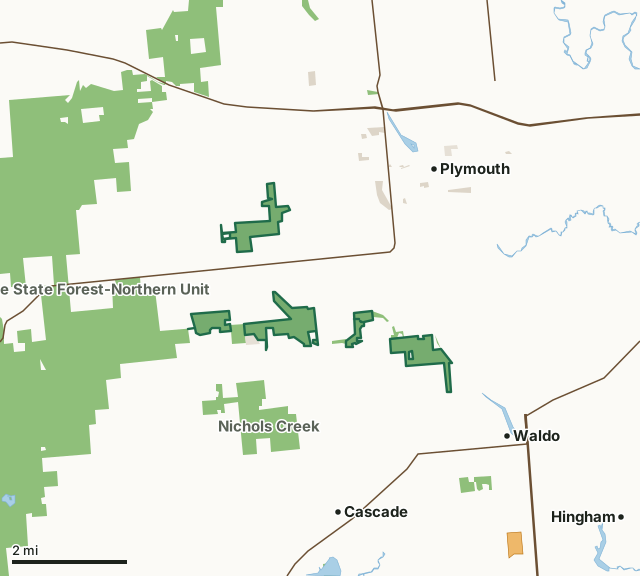
State wildlife areas, forests and other DNR landOther county, city and regional landLand trusts and other open landVoluntary Public Access landOnion River Streambank Protection AreaCounty lineLakeHighway
| Size | 1,017 acres in 5 pieces |
|---|---|
| County | Sheboygan County |
| Deer Management Unit | Sheboygan County |
| DNR lists for hunting | deer, wild turkey, pheasants, ruffed grouse, woodcock, rabbits and squirrels and small game |
| Public access (DNR) | Open to Hiking, Fishing, Hunting and Trapping |
| DNR property page | Onion River Fishery Area and Stream Bank Protection Area |
| Nearest towns | Waldo (next to it), Plymouth (3 mi) and Cascade (3 mi) |
What is Onion River Streambank Protection Area like?
The Onion River Fishery Area and Stream Bank Protection Area (SBPA) is the premier trout fishing property in this region. The properties that make up the Onion River Fishery Area and Stream Bank Protection Area are located within the Plymouth, Lyndon and Mitchell townships in Sheboygan County. The department currently owns 1,071 acres plus 50 acres in easements in the SBPA and 49 acres in the fishery area. The restoration of the Onion River is an exemplary collaboration that involved the Lakeshore Chapter of Trout Unlimited, Windway Corporation, the River Alliance of Wisconsin, the Sheboygan County Conservation Association, the Sheboygan River Basin Partnerships, Michels Corporation, private citizens and DNR. These efforts restored the stream to Class 1 trout stream status.
The Onion River is formed by the confluence of two spring-fed, headwater streams (Ben Nutt Creek and Mill Creek). Ben Nutt Creek, Mill Creek and a 5.2-mile segment of the upper Onion River from the confluence to County Highway N are classified as Class 1 trout streams (i.e., trout populations are sustained by natural reproduction). Public access is provided on about 9.5 miles of the 13.6 miles of stream frontage within the project boundary. The dominant habitats on the Onion River are lowland hardwood forests and grasslands with minor amounts of upland hardwoods and shrublands. This property consists of several parcels along the Onion River, Ben Nutt Creek and Mill Creek. This property also contains the Kamrath Creek Forest and Fen Primary Site (60 acres) which is recommended for state natural area status.
In the DNR's words, from its page for the property.
What can you hunt on Onion River Streambank Protection Area?
The DNR's page for Onion River Streambank Protection Area names deer, wild turkey, pheasants, ruffed grouse, woodcock, rabbits and squirrels and small game. Each follows Wisconsin's statewide season and, for deer, the tags and rules of the deer management unit.
What are the rules on Onion River Streambank Protection Area?
The DNR's property map lists Onion River Streambank Protection Area as "Open to Hiking, Fishing, Hunting and Trapping". Hunting follows Wisconsin's statewide seasons and the rules posted on the property.
Activities the DNR lists for Onion River Streambank Protection Area: Hunting - deer, turkey & small game, Trapping, Hiking, Snowmobiling (only on the county-wide trail segment that runs through the property), Cross-country skiing, Wildlife viewing, Fishing - trout, Bird watching, Pets and Berry picking.
How many deer are taken around Onion River Streambank Protection Area?
Onion River Streambank Protection Area lies in Sheboygan County. The DNR registered 3,562 deer in Sheboygan County in 2025, against 3,536 in 2024.
| DMU | Onion River Streambank Protection Area acres in it | Deer, 2025 | Deer, 2024 | Deer, 2023 |
|---|---|---|---|---|
| Sheboygan County | 1,017 | 3,562 | 3,536 | 3,251 |
Harvest for the whole deer management unit, not the property alone: Wisconsin DNR Deer Metrics (registered harvest by deer management unit).
How do you get to Onion River Streambank Protection Area?
Nearest towns: Waldo (next to it), Plymouth (3 miles), Cascade (3 miles) and Hingham (4 miles). Highways within 5 miles: WI 23, WI 67, WI 28 and WI 57. 1 VPA property within 3 miles.
What other public land is near Onion River Streambank Protection Area?
DNR properties within 10 miles:
- Kettle Moraine State Forest-Northern Unit: 30,281 acres, next to it
- Nichols Creek Wildlife Area: 660 acres, 0.5 miles away
- State Ice Age Trail Area (SIATA): 4,676 acres, 2.5 miles away
Public land within 3 miles of Onion River Streambank Protection Area
Counting Onion River Streambank Protection Area itself, 7,243 of the 47,077 acres within 3 miles of its boundary are public land open to the public (15.4%), by USGS PAD-US 4.1 (fee land open to the public).
| Manager | Acres within 3 miles |
|---|---|
| State wildlife areas, forests and other DNR land | 7,075 |
| Other county, city and regional land | 130 |
| Land trusts and other open land | 38 |
Questions hunters ask
Where is Onion River Streambank Protection Area?
In Sheboygan County, next to Waldo. The DNR's property page has its maps and parking.
Is Onion River Streambank Protection Area open to hunting?
Yes. The DNR's property map lists it as "Open to Hiking, Fishing, Hunting and Trapping". Posted refuges or closed areas, where there are any, are marked on site.
Which deer management unit is Onion River Streambank Protection Area in?
Sheboygan County.
How much public land is around Onion River Streambank Protection Area?
7,243 acres within 3 miles of its boundary, Onion River Streambank Protection Area included, by PAD-US 4.1. The closest other DNR property is Kettle Moraine State Forest-Northern Unit (next to it).
Get a Wisconsin hunt plan when they open
Hunt plans for Wisconsin are coming. Join the list and you'll hear first. The first 50 hunters in each new state get their plan free.
Until then, the free FilledTag app for iPhone has a map that works in every state, Wisconsin included.
Where these facts come from
- Area description, species, rules and directions: DNR, Onion River Streambank Protection Area; Wisconsin DNR managed lands open to hunting.
- Boundary and acres: the DNR's map layer above. Surrounding public land: USGS PAD-US 4.1 (fee land open to the public).
- Deer harvest: Wisconsin DNR Deer Metrics (registered harvest by deer management unit).
FilledTag is not part of the Wisconsin Department of Natural Resources. Check the DNR's rules and posted signs before you go.