Nichols Creek Wildlife Area: hunting and access
Nichols Creek Wildlife Area is 660 acres of land managed by the Wisconsin DNR in Sheboygan County, next to Cascade. The DNR's page for it names pheasants among the game here. Hunters registered 3,562 deer in Sheboygan County in 2025.
Data updated October 2026. Area facts: the DNR's DNR property data, read 2026-10. Harvest: DNR Deer Metrics.
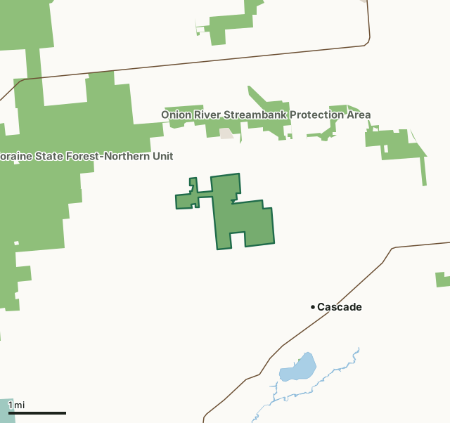
State wildlife areas, forests and other DNR landNational wildlife refuges and waterfowl production areasOther county, city and regional landLand trusts and other open landNichols Creek Wildlife AreaCounty lineLakeHighway
| Size | 660 acres |
|---|---|
| County | Sheboygan County |
| Deer Management Unit | Sheboygan County |
| DNR lists for hunting | pheasants |
| Public access (DNR) | Open to Hiking, Fishing, Hunting and Trapping |
| DNR property page | Nichols Creek Wildlife Area |
| Nearest towns | Cascade (next to it), Waldo (4 mi) and Plymouth (5 mi) |
What is Nichols Creek Wildlife Area like?
Nichols Creek Wildlife Area is a 612-acre property located in the southwest portion of Sheboygan County, about 4 miles southwest of Plymouth and just northwest of the Village of Cascade. The main access is a parking area located along County Highway N, about 2 miles west of County Highway E. The property includes several coldwater seeps and spring runs that combine to form Nichols Creek. The creek then forms the North Branch of the Milwaukee River before flowing off of the property at the southeast corner. Nichols Creek is a class 1 trout stream where anglers can expect to find naturally producing brook and brown trout. Lowland woodlands of northern white cedar, black ash, tamarack and yellow birch and shrub-carr of speckled alder and red-osier dogwood parallel the springs and creek as it meanders through the property.
Marsh marigolds and skunk cabbage are two of the most prevalent spring ephemerals present in the understory. Rolling uplands with restored prairies, grasslands and northern hardwoods of maple, basswood and ash are located in the property's southern, western and northern portions of the property. This variety of habitat supports many wildlife species throughout the year. Past uses were timber harvest and farming. Interest in state acquisition of the Nichols Creek Wildlife Area first arose in 1946 when a choice parcel of land and stream were in danger of being purchased by a group of sportsmen to be used as a private hunting and fishing area. Various conservation organizations in Sheboygan County joined forces to raise money for the purchase of this area to ensure public access to the stream.
In the DNR's words, from its page for the property.
What can you hunt on Nichols Creek Wildlife Area?
The DNR's page for Nichols Creek Wildlife Area names pheasants. Each follows Wisconsin's statewide season and, for deer, the tags and rules of the deer management unit.
What are the rules on Nichols Creek Wildlife Area?
The DNR's property map lists Nichols Creek Wildlife Area as "Open to Hiking, Fishing, Hunting and Trapping". Hunting follows Wisconsin's statewide seasons and the rules posted on the property.
Activities the DNR lists for Nichols Creek Wildlife Area: Cross-country skiing (no designated trail), Fishing, Hiking (no designated trail), Trapping, Wild edibles/gathering and Wildlife viewing.
How many deer are taken around Nichols Creek Wildlife Area?
Nichols Creek Wildlife Area lies in Sheboygan County. The DNR registered 3,562 deer in Sheboygan County in 2025, against 3,536 in 2024.
| DMU | Nichols Creek Wildlife Area acres in it | Deer, 2025 | Deer, 2024 | Deer, 2023 |
|---|---|---|---|---|
| Sheboygan County | 660 | 3,562 | 3,536 | 3,251 |
Harvest for the whole deer management unit, not the property alone: Wisconsin DNR Deer Metrics (registered harvest by deer management unit).
How do you get to Nichols Creek Wildlife Area?
Nearest towns: Cascade (next to it), Waldo (4 miles), Plymouth (5 miles) and Adell (5 miles). Highways within 5 miles: WI 28, WI 67, WI 57 and WI 23.
What other public land is near Nichols Creek Wildlife Area?
DNR properties within 10 miles:
- Onion River Streambank Protection Area: 1,017 acres, 0.5 miles away
- Kettle Moraine State Forest-Northern Unit: 30,281 acres, 0.8 miles away
- Lake Ellen Public Access: 40 acres, 2 miles away
- State Ice Age Trail Area (SIATA): 4,676 acres, 5.1 miles away
Public land within 3 miles of Nichols Creek Wildlife Area
Counting Nichols Creek Wildlife Area itself, 4,697 of the 28,443 acres within 3 miles of its boundary are public land open to the public (16.5%), by USGS PAD-US 4.1 (fee land open to the public).
| Manager | Acres within 3 miles |
|---|---|
| State wildlife areas, forests and other DNR land | 4,673 |
| Land trusts and other open land | 24 |
Questions hunters ask
Where is Nichols Creek Wildlife Area?
In Sheboygan County, next to Cascade. The DNR's property page has its maps and parking.
Is Nichols Creek Wildlife Area open to hunting?
Yes. The DNR's property map lists it as "Open to Hiking, Fishing, Hunting and Trapping". Posted refuges or closed areas, where there are any, are marked on site.
Which deer management unit is Nichols Creek Wildlife Area in?
Sheboygan County.
How much public land is around Nichols Creek Wildlife Area?
4,697 acres within 3 miles of its boundary, Nichols Creek Wildlife Area included, by PAD-US 4.1. The closest other DNR property is Onion River Streambank Protection Area (0.5 miles).
Get a Wisconsin hunt plan when they open
Hunt plans for Wisconsin are coming. Join the list and you'll hear first. The first 50 hunters in each new state get their plan free.
Until then, the free FilledTag app for iPhone has a map that works in every state, Wisconsin included.
Where these facts come from
- Area description, species, rules and directions: DNR, Nichols Creek Wildlife Area; Wisconsin DNR managed lands open to hunting.
- Boundary and acres: the DNR's map layer above. Surrounding public land: USGS PAD-US 4.1 (fee land open to the public).
- Deer harvest: Wisconsin DNR Deer Metrics (registered harvest by deer management unit).
FilledTag is not part of the Wisconsin Department of Natural Resources. Check the DNR's rules and posted signs before you go.