La Budde Creek Fishery Area: hunting and access
La Budde Creek Fishery Area is 392 acres of land managed by the Wisconsin DNR in Sheboygan County, next to Elkhart Lake. The DNR's page for it names deer, wild turkey, pheasants, ducks and geese, ruffed grouse, woodcock and rabbits and squirrels among the game here. Hunters registered 3,562 deer in Sheboygan County in 2025.
Data updated October 2026. Area facts: the DNR's DNR property data, read 2026-10. Harvest: DNR Deer Metrics.
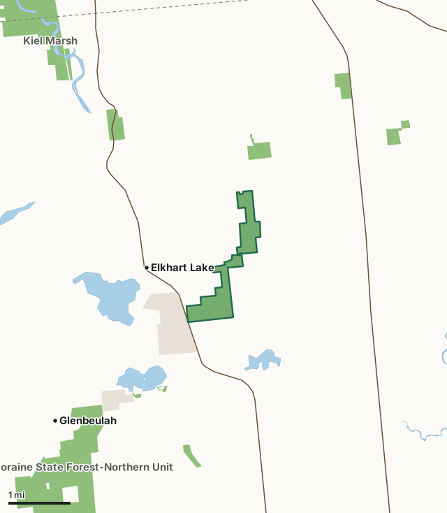
State wildlife areas, forests and other DNR landLand trusts and other open landLa Budde Creek Fishery AreaCounty lineLakeHighway
| Size | 392 acres in 2 pieces |
|---|---|
| County | Sheboygan County |
| Deer Management Unit | Sheboygan County |
| DNR lists for hunting | deer, wild turkey, pheasants, ducks and geese, ruffed grouse, woodcock and rabbits and squirrels |
| Public access (DNR) | Open to Hiking, Fishing, Hunting and Trapping |
| DNR property page | LaBudde Creek Fishery Area |
| Nearest towns | Elkhart Lake (next to it), Glenbeulah (3 mi) and Plymouth (5 mi) |
What is La Budde Creek Fishery Area like?
LaBudde Creek Fishery Area contains 426 acres along LaBudde Creek in Sheboygan County. LaBudde Creek is one of three streams in Sheboygan County where significant amounts of naturally reproduced trout are found. The stream originates from a spring pond and two wetlands that are located northeast of the Fishery Area and then flows in a southwest direction for 7 miles until it meets the Mullet River. The Mullet River merges with the Sheboygan River, which eventually flows into Lake Michigan in the City of Sheboygan. The LaBudde Creek watershed is approximately 12 square miles in size and contains wooded and grassland ecosystems. The stream obtains the majority of its flow from several seepage springs along its upper mile. It averages 8 feet in width, and 10 inches in depth, and has a relatively low gradient of 5.6 feet of drop per mile.
LaBudde Creek is classified as a class 1 and class 2 trout stream. The class 1 section starts at its origin and runs downstream approximately 4 miles to Badger Road. The class 2 section runs from there about 3 miles downstream to the Mullet River. Development activities, ditching, and grazing have reduced the fishery potential of the stream in past years. However, current water resource management practices in the watershed should serve to clean up the stream and increase the fishery potential in the future. The fish species composition of LaBudde Creek is characteristic of a cold to cool water stream fishery with brook trout, brook stickleback, pearl dace, mid minnow, common white sucker, Johnny darter, creek chub, and blacknose whiner being present. An occasional northern pike is also found in the lower, warmer reaches of the stream.
In the DNR's words, from its page for the property.
What can you hunt on La Budde Creek Fishery Area?
The DNR's page for La Budde Creek Fishery Area names deer, wild turkey, pheasants, ducks and geese, ruffed grouse, woodcock and rabbits and squirrels. Each follows Wisconsin's statewide season and, for deer, the tags and rules of the deer management unit.
What are the rules on La Budde Creek Fishery Area?
The DNR's property map lists La Budde Creek Fishery Area as "Open to Hiking, Fishing, Hunting and Trapping". Hunting follows Wisconsin's statewide seasons and the rules posted on the property.
Activities the DNR lists for La Budde Creek Fishery Area: Hunting - deer, turkey, waterfowl, pheasant, rabbit, squirrel, grouse, woodcock, mourning dove, fox, coyote, raccoon, Trapping, Hiking, Cross-country skiing and Wildlife viewing.
How many deer are taken around La Budde Creek Fishery Area?
La Budde Creek Fishery Area lies in Sheboygan County. The DNR registered 3,562 deer in Sheboygan County in 2025, against 3,536 in 2024.
| DMU | La Budde Creek Fishery Area acres in it | Deer, 2025 | Deer, 2024 | Deer, 2023 |
|---|---|---|---|---|
| Sheboygan County | 392 | 3,562 | 3,536 | 3,251 |
Harvest for the whole deer management unit, not the property alone: Wisconsin DNR Deer Metrics (registered harvest by deer management unit).
How do you get to La Budde Creek Fishery Area?
Nearest towns: Elkhart Lake (next to it), Glenbeulah (3 miles), Plymouth (5 miles) and Kiel (5 miles). Highways within 5 miles: WI 57, WI 67, WI 23 and WI 32.
What other public land is near La Budde Creek Fishery Area?
DNR properties within 10 miles:
- State Ice Age Trail Area (SIATA): 4,676 acres, 0.5 miles away
- Kettle Moraine State Forest-Northern Unit: 30,281 acres, 1.9 miles away
- Muehl Springs State Natural Area: 72 acres, 2 miles away
- Rhine Center Bog State Natural Area: 53 acres, 2.1 miles away
- Schuet Creek Fishery Area: 45 acres, 2.3 miles away
Public land within 3 miles of La Budde Creek Fishery Area
Counting La Budde Creek Fishery Area itself, 1,384 of the 29,145 acres within 3 miles of its boundary are public land open to the public (4.7%), by USGS PAD-US 4.1 (fee land open to the public).
| Manager | Acres within 3 miles |
|---|---|
| State wildlife areas, forests and other DNR land | 977 |
| Land trusts and other open land | 407 |
Questions hunters ask
Where is La Budde Creek Fishery Area?
In Sheboygan County, next to Elkhart Lake. The DNR's property page has its maps and parking.
Is La Budde Creek Fishery Area open to hunting?
Yes. The DNR's property map lists it as "Open to Hiking, Fishing, Hunting and Trapping". Posted refuges or closed areas, where there are any, are marked on site.
Which deer management unit is La Budde Creek Fishery Area in?
Sheboygan County.
How much public land is around La Budde Creek Fishery Area?
1,384 acres within 3 miles of its boundary, La Budde Creek Fishery Area included, by PAD-US 4.1. The closest other DNR property is State Ice Age Trail Area (SIATA) (0.5 miles).
Get a Wisconsin hunt plan when they open
Hunt plans for Wisconsin are coming. Join the list and you'll hear first. The first 50 hunters in each new state get their plan free.
Until then, the free FilledTag app for iPhone has a map that works in every state, Wisconsin included.
Where these facts come from
- Area description, species, rules and directions: DNR, La Budde Creek Fishery Area; Wisconsin DNR managed lands open to hunting.
- Boundary and acres: the DNR's map layer above. Surrounding public land: USGS PAD-US 4.1 (fee land open to the public).
- Deer harvest: Wisconsin DNR Deer Metrics (registered harvest by deer management unit).
FilledTag is not part of the Wisconsin Department of Natural Resources. Check the DNR's rules and posted signs before you go.